Where the rivers meet the seas
Estuaries are the places where rivers and the sea meet. They are typically semi-enclosed coastal bodies of water with a connection with the open sea and within which sea water is measurably diluted with fresh water draining from the land and waterways that feed it.
Estuaries support a range of distinctive aquatic and terrestrial plants and animals. They provide core breeding and feeding areas for waterbirds, and spawning and nursery areas for many fish species.
Vegetation adjacent to estuaries (such as mangroves, seagrasses and saltmarshes) help to maintain water quality, assist with nutrient cycling, and provide a buffer to catchment-derived sediments, nutrients and other pollutants entering the marine environment. Estuarine ecosystems are highly complex and dynamic. Since estuaries are at the end of waterways, their condition is affected by activities occurring upstream in the catchment. Where the condition of catchments, rivers or estuaries is poor, there are likely to be impacts on the marine receiving waters and coastal areas. Similarly, the condition of the marine environment can also impact the health of estuaries.
Humans have long valued estuarine areas. The region’s estuaries are important to Traditional Owners and many contain ancient sites of cultural significance.
Sheltered estuarine waters across Victoria were also among the first areas to be settled by non-Indigenous people. Many estuaries in the late 1800s and early 1900s were transport and fishing hubs, which supported prosperous industry and ports. These early settlements have since developed into some of the region’s most densely populated areas. Estuaries are valued for recreational and commercial fishing, tourism, recreation, port trade and boating.
Policy and planning
There are a number of agencies and organisations that have a role in the protection and management of wetlands.
The Marine and Coastal Act (2018) provides an integrated and coordinated approach to planning and managing Victoria’s marine and coastal environment by:
- enabling protection of the coastline and the ability to address the long-term challenges of climate change, population growth and ageing coastal structures
- ensuring that partners work together to achieve the best outcomes for Victoria’s marine and coastal environment.
The Act is complemented by The Marine and Coastal Policy which sets out policies for planning and managing the marine and coastal environment, and provides guidance to decision makers in achieving the Act’s objectives.
The Victorian Government’s Water for Victoria policy and the Victorian Waterway Management Strategy provide the state-wide policy framework for water and waterway management and includes consideration of estuaries.
In the Port Phillip and Western Port region, Melbourne Water is the designated waterway management authority and has led the development of the Healthy Waterways Strategy 2018-28 which outlines this region’s contribution to meeting the state-wide aims and establishes the vision for the health of rivers, estuaries and wetlands in this region.
The Environment Protection Authority manages a set of State environment protection policies (SEPPs) that apply across Victoria. The SEPP (Waters) provides for the protection and management of surface water and groundwater in Victoria by establishing in law the uses and environmental values to be protected, defining the level of environmental quality required for their protection, and setting rules and obligations to ensure management actions are taken to protect water quality.
Traditional Owners are the voice of their Country
For all policy and planning, there is a need for recognition and inclusion of Traditional Owner knowledge and aspirations (see target 13.1). The water and lands are increasingly being recognised as ‘living and integrated natural entities‘ and the Traditional Owners should be recognised as the ‘voice of these living entities’. Country Plans will describe the vision and priorities of the Traditional Owners for Country in line with their roles as Registered Aboriginal Parties, and will provide a strong basis for all planning to recognise and include the voice of these Traditional Owners.
Estuaries in this region today
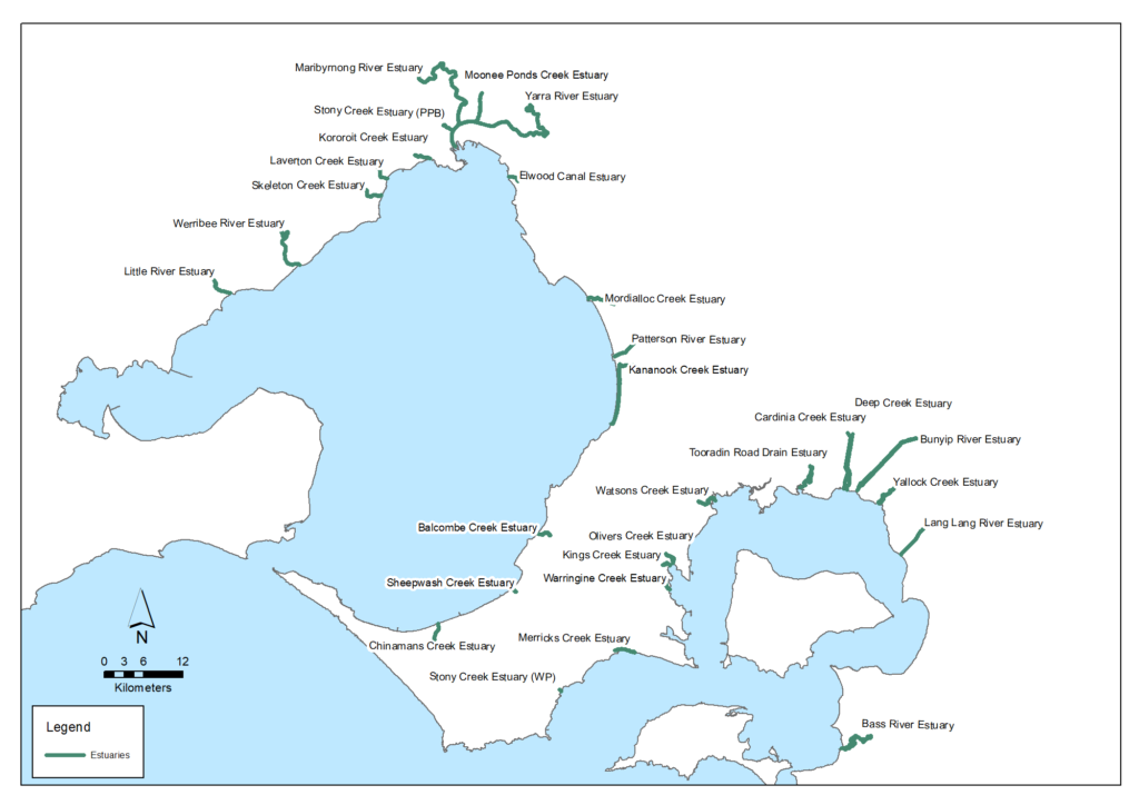
There are 33 estuaries within this region. They include those that are permanently open to the sea such as the Werribee, Maribyrnong and Yarra, and those which are naturally intermittently open and closed to the sea such as the Balcombe and Merricks creeks estuaries.
Index of estuary condition
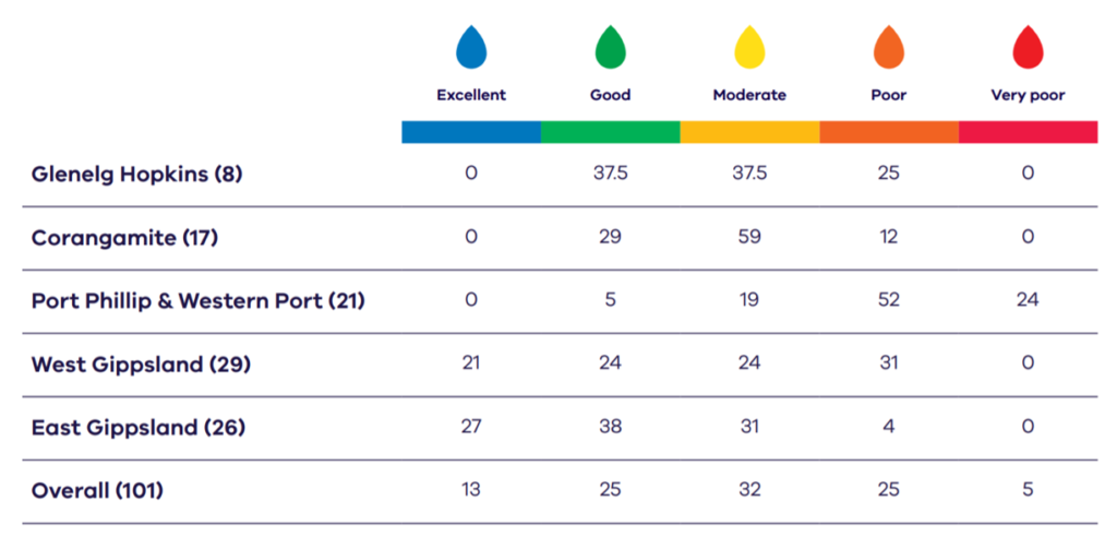
A statewide Assessment of Victoria’s estuaries using the Index of Estuary Condition was published in 2021 with all 101 of Victoria’s large estuaries assessed. Some points from the report regarding estuaries in this region include: Percentage of estuaries in each assessment class.
- Of the 21 estuaries assessed in this region, none are assessed in as being in Excellent condition
- Only the Saltwater Creek estuary (part of the Phillip Island Nature Parks) is assessed as in Good condition
- The Laverton, Warringine and Cardinia Creeks and Bass River estuaries are assessed as in Moderate condition
- The remainder are in Poor and Very poor condition
- The Port Phillip & Western Port region has the highest proportion of estuaries in Victoria in Poor and Very poor condition.
Estuary condition by catchment
The condition of estuaries by catchment across the region (from 2018) is also outlined in the Healthy Waterways Strategy 2018-2028 and summarised below. It should be noted that this uses a different assessment method than the state-wide Index of Estuary Condition.
Westernport catchment
The estuary birds score is currently moderate overall, but is likely to decline due to predicted climate change impacts. These impacts can be somewhat mitigated so the long-term target is to maintain at moderate.
The fish score for estuaries is high and is predicted to remain high in the long-term. A good diversity of estuarine dependent species inhabit the estuaries and are likely to remain. The target is to maintain at high for estuaries.
The estuarine vegetation score is currently considered moderate, with a current trajectory of very low. Forward planning for adaption and migration of coastal wetland and estuarine vegetation is essential in light of predicted climate change impacts. Protection of significant coastal saltmarsh vegetation is a priority.
Recreation is currently low and is predicted to be maintained at low. The target is to improve to moderate. Fishing and boating are popular in this catchment, along with walking and passive recreation in some estuaries.
Assessment of estuary values and conditions in the Westernport catchment at 2018 (from the Healthy Waterways Strategy)
| Estuary values | 2018 state | 2018 trajectory | 2068 target |
|---|---|---|---|
| Birds | Moderate | Low | Moderate |
| Fish | High | High | High |
| Vegetation | Moderate | Very low | Moderate |
| Amenity | Moderate | Moderate | Moderate |
| Community connection | High | High | High |
| Recreation | Low | Low | Moderate |
| Estuary conditions | 2018 state | 2018 trajectory | 2068 target |
|---|---|---|---|
| Flow regime | Moderate | Very low | Low |
| Tidal exchange | Very high | Very high | Very high |
| Longitudinal extent | Very high | Very high | Very high |
| Water quality | Low | Very low | Moderate |
| Estuarine vegetation | Moderate | Very low | High |
| Estuarine wetland connectivity | Low | Low | Moderate |
Dandenong catchment
The estuary birds score is currently very low and is predicted to remain very low. The estuaries are fringed by highly urbanised areas and the predicted climate change impacts will further erode suitable bird habitat.
The fish value score for estuaries in the Dandenong Catchment is high and predicted to remain high in the long term. A good diversity of estuarine dependent species inhabit the estuaries and are likely to remain.
The estuarine vegetation score is currently considered low with a current trajectory of very low. Adopting some climate change adaption strategies may mitigate some of the risk to estuarine vegetation; however, this will only allow the value to be maintained at low. The estuaries are fringed by highly urbanised environments allowing little potential for estuarine vegetation communities to migrate into more favourable less saline conditions.
The recreation score is currently high and is predicted to improve to very high. The estuaries are hubs of recreational activity.
Assessment of estuary values and conditions in the Dandenong catchment at 2018 (from the Healthy Waterways Strategy)
| Estuary values | 2018 state | 2018 trajectory | 2068 target |
|---|---|---|---|
| Birds | Very low | Very low | Very low |
| Fish | High | High | High |
| Vegetation | Low | Very low | Low |
| Amenity | High | High | High |
| Community connection | Very high | Very high | Very high |
| Recreation | High | High | Very high |
| Estuary conditions | 2018 state | 2018 trajectory | 2068 target |
|---|---|---|---|
| Flow regime | Very low | Very low | Low |
| Tidal exchange | Very high | Very high | Very high |
| Longitudinal extent | Low | Moderate | Moderate |
| Water quality | High | Low | Moderate |
| Estuarine vegetation | Very low | Very low | Low |
| Estuarine wetland connectivity | Very low | Very low | Low |
Yarra catchment
The estuary birds score is currently very low due to the historical loss of habitat, industrial and urban development.
The fish score is currently very high, with significant species such as the Australian Grayling using the estuary as part of its migration path between the sea and fresh waters. A good diversity of estuarine dependent fish species also inhabit the estuary.
The vegetation score is currently very low due to the historical loss of habitat, and industrial and urban development.
The amenity score is currently very high and is expected to remain very high with continued improvements to parks, facilities and vegetation. Community connection score is currently very high. The Yarra River estuary is an iconic location loved by visitors and locals to Melbourne.
The recreation score is currently very high and will remain high. The estuary is a hub of activity including boating, cycling and walking.
Assessment of estuary values and conditions in the Yarra catchment at 2018 (from the Healthy Waterways Strategy)
| Estuary values | 2018 state | 2018 trajectory | 2068 target |
|---|---|---|---|
| Birds | Very low | Very low | Very low |
| Fish | Very high | Very high | Very high |
| Vegetation | Very low | Very low | Very low |
| Amenity | Very high | Very high | Very high |
| Community connection | Very high | Very high | Very high |
| Recreation | Very high | Very high | Very high |
| Estuary conditions | 2018 state | 2018 trajectory | 2068 target |
|---|---|---|---|
| Flow regime | Very low | Very low | High |
| Tidal exchange | Very high | Very high | Very high |
| Longitudinal extent | Very high | Very high | Very high |
| Water quality | Very low | Very low | Low |
| Estuarine vegetation | Very low | Very low | Low |
| Estuarine wetland connectivity | Very low | Very low | Low |
Maribyrnong catchment
The estuary birds score for estuaries is currently very low. The estuaries are fringed by highly urban environments and the predicted climate change impacts will further erode suitable wetland bird habitat.
The fish score for estuaries is high and is predicted to remain high in the long term. A good diversity of estuarine dependent species inhabits the estuaries and are likely to remain. There are also several estuarine species, including black bream, yellow-eye mullet and mulloway.
The estuarine vegetation score is currently very low and likely to continue to decline. Adopting some climate change adaption strategies may mitigate some of the risk to estuarine vegetation and improve the vegetation value score to low. The estuaries are fringed by highly urbanised environments allowing little potential for estuarine vegetation communities to migrate into more favourable less saline conditions.
The amenity score is moderate with a current trajectory of moderate. Increased tracks, pathways and other facilities, along with improvements to estuarine vegetation are predicted to improve the amenity score to high.
Assessment of estuary values and conditions in the Maribyrnong catchment at 2018 (from the Healthy Waterways Strategy)
| Estuary values | 2018 state | 2018 trajectory | 2068 target |
|---|---|---|---|
| Birds | Very low | Very low | Very low |
| Fish | High | High | High |
| Vegetation | Very low | Very low | Low |
| Amenity | Moderate | Moderate | High |
| Community connection | Very high | Very high | Very high |
| Recreation | Moderate | Moderate | High |
| Estuary conditions | 2018 state | 2018 trajectory | 2068 target |
|---|---|---|---|
| Flow regime | Very low | Very low | Low |
| Tidal exchange | Very high | Very high | Very high |
| Longitudinal extent | Moderate | High | High |
| Water quality | Very low | Very low | Moderate |
| Estuarine vegetation | Very low | Very low | Low |
| Estuarine wetland connectivity | Very low | Very low | Low |
Werribee catchment
The estuaries bird score is currently moderate, with a current trajectory of low. Improvement to estuarine wetlands connectivity, vegetation and flow regime will maintain the bird score at moderate. The Little River and Werribee estuaries provide significant habitat.
The fish score for estuaries is high with a current trajectory of moderate. Changes to the estuarine water regime as a result of urbanisation and climate change may impact fish communities. A good diversity of estuarine dependent species inhabit the estuaries and are likely to remain.
The vegetation score is currently low with a current trajectory of very low. Forward planning for adaption and migration of coastal wetland and estuarine vegetation is essential in light of predicted climate change impacts.
The amenity score is moderate with a current trajectory of moderate. Increased tracks, pathways and other facilities, along with improvements to estuarine vegetation are predicted to improve the amenity value to high.
Assessment of estuary values and conditions in the Werribee catchment at 2018 (from the Healthy Waterways Strategy)
| Estuary values | 2018 state | 2018 trajectory | 2068 target |
|---|---|---|---|
| Birds | Moderate | Low | Moderate |
| Fish | High | Low | High |
| Vegetation | Low | Very low | Moderate |
| Amenity | Moderate | Moderate | Very high |
| Community connection | Very high | Very high | Very high |
| Recreation | Moderate | Moderate | High |
| Estuary conditions | 2018 state | 2018 trajectory | 2068 target |
|---|---|---|---|
| Flow regime | Very low | Very low | Moderate |
| Tidal exchange | High | Moderate | High |
| Longitudinal extent | Moderate | High | High |
| Water quality | Moderate | Very low | Low |
| Estuarine vegetation | Low | Very low | Moderate |
| Estuarine wetland connectivity | Low | Low | Moderate |
Key challenges
Estuarine ecosystems are highly complex and dynamic environments. Since estuaries are at the bottom end of catchments, their condition can be affected by activities occurring within the upstream freshwater catchment. Where the condition of catchments, rivers or estuaries is poor, there are likely to be additional impacts on the marine receiving waters and coastal areas.
Climate change
With sea levels projected to rise, combined with an increase in storm surge events and reduced inflows, climate change is expected to greatly impact all estuaries in the region.
Population growth and urbanisation
Many of the estuaries in our region are surrounded by dense coastal settlements and can be exposed to intensive levels of recreation and use. The establishment of townships within close proximity to many of the region’s estuaries places pressure on how these function. The effect of run-off and pollution from these settlements can also have an impact on estuary health. There can also be a high level of expectation from some affected stakeholders that estuaries will be opened when there is a threat of flooding to private property and infrastructure.
Other threats
- Unpermitted estuary entrance openings, e.g. use of machinery to remove sand from the estuary mouth so it flows into the ocean, under unfavourable circumstances can cause fish death events, reduced water quality and interference with life cycles
- Changes in water regimes – particularly reduced freshwater inflows from rivers
- High levels of sediment and nutrients
- Pollution events, e.g. oil spills
- Habitat modification
- Land-claim (creating new land from areas that were previously below high tide
- Invasion by weeds or pest animals
- Salinisation, acidification and acid sulfate soils.
Vision and targets for the future
Vision
The Healthy Waterways Strategy outlines the following 50-year vision which relates to waterways, wetlands and estuaries of this region:
Healthy and valued waterways are integrated with the broader landscape, and enhance life and liveability. Waterways connect diverse and thriving communities of plants and animals; provide amenity to urban and rural areas, and engage communities with their environment; and are managed sustainably to enhance environmental, economic, social and cultural values.
The Healthy Waterways Strategy also provides catchment-scale visions as summarised below.
Targets
Following is a small selection of targets for estuaries drawn from the Healthy Waterways Strategy. More detail on the ratings of waterways are available in the Healthy Waterways Strategy. Progress towards these targets will be primarily monitored through the ongoing Healthy Waterways Strategy monitoring and reporting program led by the Melbourne Water.
Target 11.1 – Estuarine flow regime
Target 11.2 – Estuarine vegetation
Partner organisations
The following organisations formally support the pursuit of the visions and targets for estuaries. They have agreed to provide leadership and support to help achieve optimum results with their available resources, in ways such as:
- Fostering partnerships and sharing knowledge, experiences and information with other organisations and the community
- Seeking and securing resources for the area and undertaking work that will contribute to achieving the visions and targets
- Assisting with monitoring and reporting on the condition of the area.
Victorian Government
- Melbourne Water
- Parks Victoria
- Trust for Nature
- Victorian Fisheries Authority
- Zoos Victoria
- Department of Energy, Environment and Climate Action (DEECA)
- Environment Protection Authority Victoria (EPA)
- Sustainability Victoria
- Westernport Water
Local Government
- Association of Bayside Municipalities
- Wyndham City
- City of Greater Geelong
- City of Casey
- Cardinia Shire Council
- Bass Coast Shire Council
- Kingston City Council
- Hobsons Bay City Council
- Bayside City Council
- City of Greater Dandenong
- Western Alliance for Greenhouse Action
- Northern Alliance for Greenhouse Action
- South East Councils Climate Change Alliance
- Eastern Alliance for Greenhouse Action
Traditional Owners
- Wadawurrung Traditional Owners Aboriginal Corporation
- Bunurong Land Council Aboriginal Corporation
Non Government
- The Nature Conservancy
- Birdlife Australia
- Marine Mammal Foundation
- Dolphin Research Institute
- Western Port Seagrass Partnership
- Habitat Restoration Fund
- Victorian National Parks Association
- Conservation Volunteers Australia
- Native Fish Australia (Vic)
- OzFish Unlimited
- The People and Parks Foundation
- Field Naturalists Club of Victoria
Community
- Bass Coast Landcare Network
- Bass Valley Landcare Group
- South Gippsland Landcare Network
- Loch-Nyora Landcare Group
- Mt. Lyall Landcare Group
- Poowong & District Landcare Group
- Triholm Landcare Group
- Phillip Island Landcare Group
- Westernport Swamp Landcare Group
- Gippsland Threatened Species Action Group
- Main Creek Catchment Landcare Group
- Merricks Coolart Catchment Landcare Group
- NatureWest
- Little River Community Landcare Inc
- Friends of Lower Kororoit Creek Inc
- Hobsons Bay Wetlands Centre Inc.
- Werribee River Association
- Northern Yarra Landcare Network
Add your organisation as a supporter and partner
If your organisation supports these directions and targets for estuaries and wishes to be listed as a partner organisation, you can request to be listed as a partner organisation. Adding your organisation to this list will:
- Enable your organisation to list one or more priority projects in the Prospectus which will describe how your priority project will pursue the targets of this Regional Catchment Strategy and potentially make your organisation’s project more attractive to investors by using the strategy to highlight its relevance and value
- Demonstrate your commitment to a healthy and sustainable environment
- Demonstrate the level of community engagement and support for this work.
Priority projects to move forward
Priority projects
There are significant ongoing programs and initiatives undertaken by many organisations in this region that are vital for protecting and enhancing estuaries and are priorities to continue. These include programs led by Councils, Melbourne Water, Parks Victoria, the Department of Energy, Environment and Climate Action, community groups and non-Government organisations. In addition, there are numerous project proposals that, if funded and implemented, can contribute to achieving the Regional Catchment Strategy’s visions and targets. A list of project proposals across the region and their key details can be viewed on the Prospectus section of this website.
Propose a new priority project
As part of the ongoing development and refinement of this Regional Catchment Strategy, additional priority projects may be considered for inclusion in the Prospectus.
If your organisation supports the directions and targets for estuaries, and has a project it would like highlighted and supported in this Regional Catchment Strategy, please submit a Prospectus Project Proposal.

