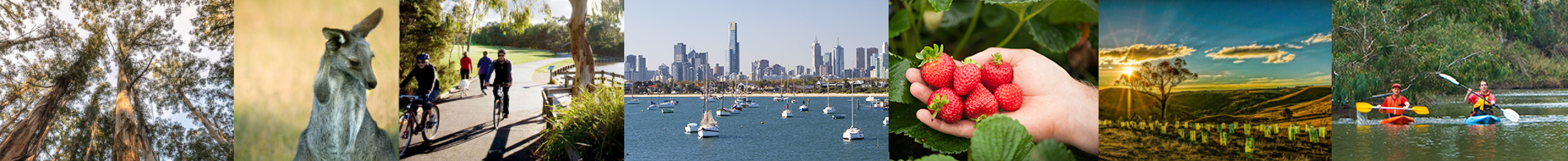
Balancing urban and rural living
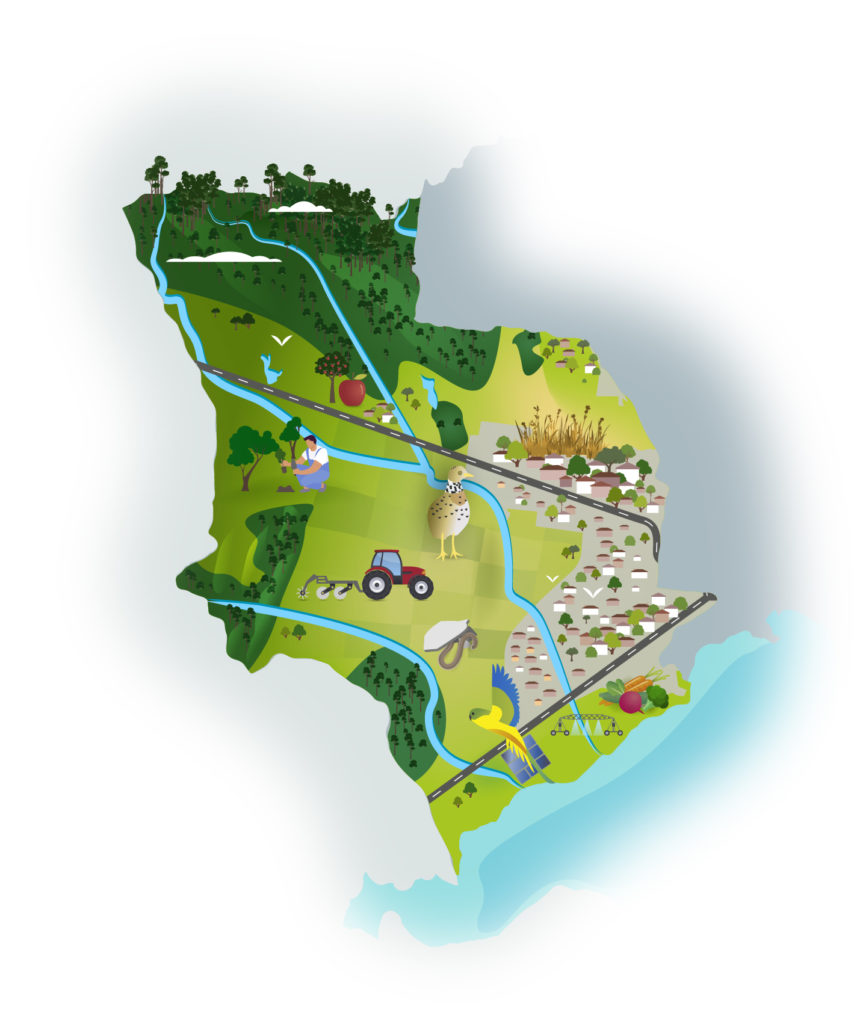
This area west of Melbourne features part of the vast Victorian Volcanic Plains that stretch from here across western Victoria. The lava that created these plains boiled from the earth over the last 6 million years. The most recent eruptions are estimated to be only 10,000 years old. Mount Atkinson and Mount Cottrell are two prominent remains of these volcanic vents.
The You Yangs and Brisbane Ranges mark the western border of the area and the rugged forested hills and gorges of the Lerderderg State Park are at its north. To the south, the plains merge into coastal wetlands and Port Phillip Bay while Melbourne’s urban sprawl defines its eastern edge.
The urban sprawl is recent here. The open plain west of Melbourne offered little attraction or shelter for residential development in Melbourne’s first century and its heavy clays, few streams and sparse rainfall offered limited grazing value. Cereal cropping was won by clearing millions of basalt boulders from the better soils.
However, over the past two decades, population growth has seen large parcels of previously undeveloped land being released for housing estates. Population modelling suggests the region will be home to more than one million people in the next 20 years, which will require an additional 8,000 dwellings per year. Much of this will be in the new urban development area that stretches out from Melbourne to Melton and Bacchus Marsh to the north-west, and west towards Werribee and Little River.
Despite this rapid urbanisation, agriculture remains an important land use in the region with cropping and grazing featuring on the plains and valuable market gardens located around Bacchus Marsh and Werribee being key suppliers of vegetables for local, national and international markets.
The region has a rich natural environment with an extensive coastline and rivers and creeks such as Little River, Werribee River, Lerderderg River, Toolern Creek, Skeleton Creek and Kororoit Creek, which all drain into the north-west part of Port Phillip Bay. It is home to the Western and Derrimut Grassland Reserves and wetlands of international significance under the Ramsar Convention. The plains, their scattered woodlands, wetlands and small streams in rocky ravines offer a dazzling, diverse ecology of plants and animals
This area has been, and still is, a rich home for Aboriginal people. Alongside the Traditional Owners, many communities and agencies are intent on saving the area’s remaining and threatened animals, plants and ecosystems.
The condition of our environment now
Kulin Nation Country
This area is Kulin Nation Country. Archaeological evidence shows the land, coasts and waterways of the area supported Aboriginal people for tens of thousands of years. A burial site on the banks of the Werribee River is 7,300 years old. The Wadawurrung Traditional Owners Aboriginal Corporation is the Registered Aboriginal Party for Country in the western part of this area. The Wurundjeri Woi-wurrung Cultural Heritage Aboriginal Corporation is the Registered Aboriginal Party for Country in the northern part of this area. The Bunurong Land Council Aboriginal Corporation is the Registered Aboriginal Party for Country in the south east of this area. They continue the modern movement by Traditional Owners to practice and strengthen their culture and care for this Country.
Land use
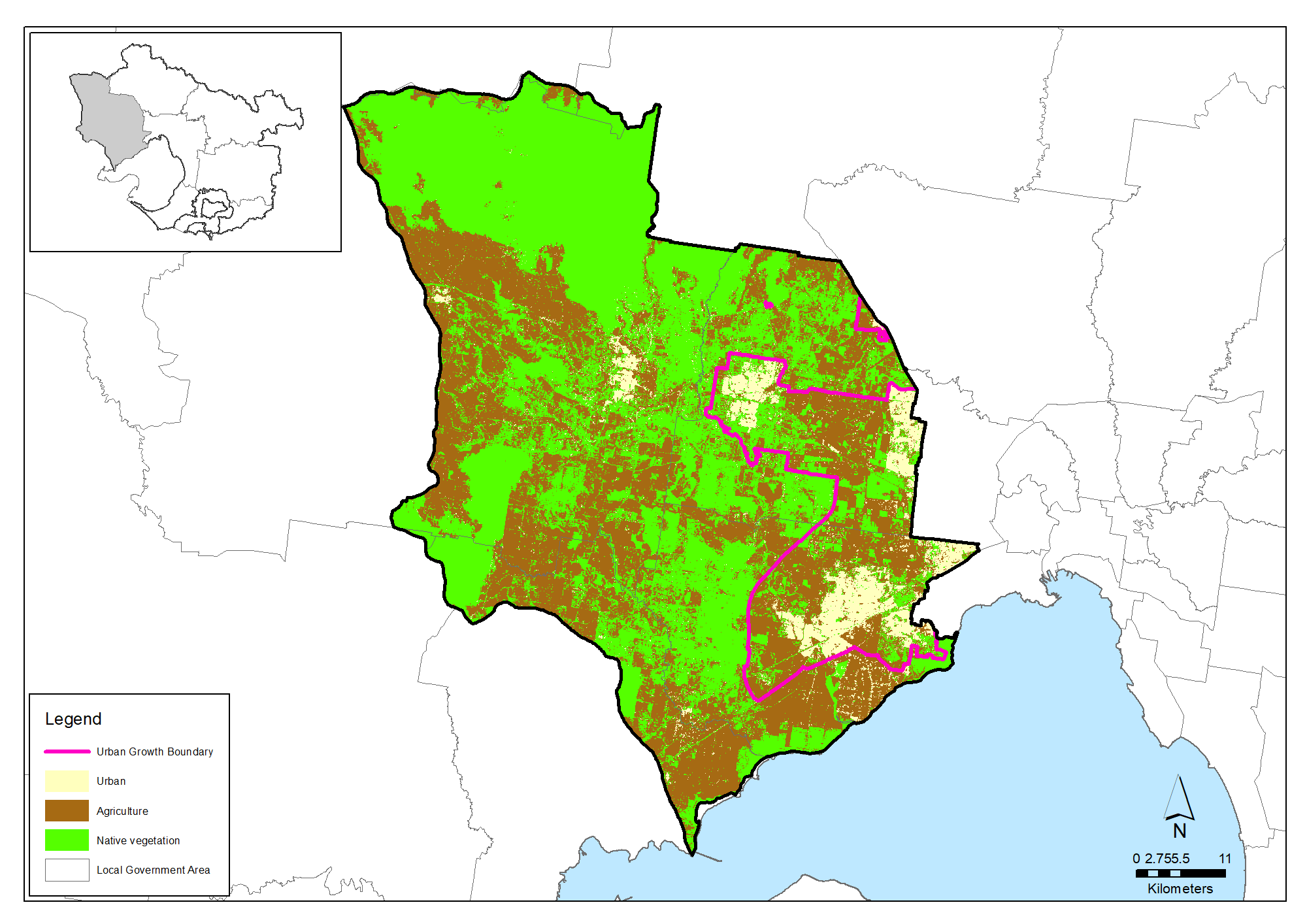
The Moorabool, Melton, Wyndham & Greater Geelong area covers 251,541 hectares. It comprises the Cities of Melton and Wyndham, about half the Shire of Moorabool and about one-fifth of the City of Greater Geelong. About 53 per cent of the area retains its natural vegetation, 41 per cent is used for agriculture and 6 per cent is urban (confined to greater Melbourne and larger townships within the catchment). The area lies in the rain shadow of the Otway Ranges and is the driest area south of the Great Dividing Range in Victoria. Long-term average rainfalls are in the vicinity of 700mm per year across the Werribee Plains; half that of the Yarra and Dandenong Ranges.
Urban development and population growth are major forces in natural resource management in the area. The Western Growth Corridor plan aims to accommodate a population of 377,000 in coming decades. Associated infrastructure includes extended industrial zones, connections to existing and new port and interstate freight terminals, a new Outer Ring Road, freeway and rail lines and six new ‘higher order’ town centres. Enhanced natural features, regional parklands, creeks and waterways are important parts of the plan for the amenity of this future population.
Predicted population and dwelling increases in Moorabool, Melton, Wyndham & Greater Geelong
| Population 2021 | Population 2041 | Dwellings 2016 | Dwellings 2041 | |
| Moorabool* | 30,300 | 57,200 | 10,600 | 22,400 |
| Melton | 185,000 | 365,220 | 47,000 | 117,000 (est) |
| Wyndham | 302,000 | 512,000 | 75,800 | 178,300 |
| Greater Geelong** | ||||
| TOTAL | 517,300 | 934,420 | 133,400 | 317,700 |
* Calculated for the whole of Moorabool Shire minus its western rural division. ** It was not practicable to forecast population or development for the part of Greater Geelong in the Port Phillip & Western Port region. The figure is not likely to be significant compared to magnitudes of change in Moorabool, Melton and Wyndham.
Agriculture
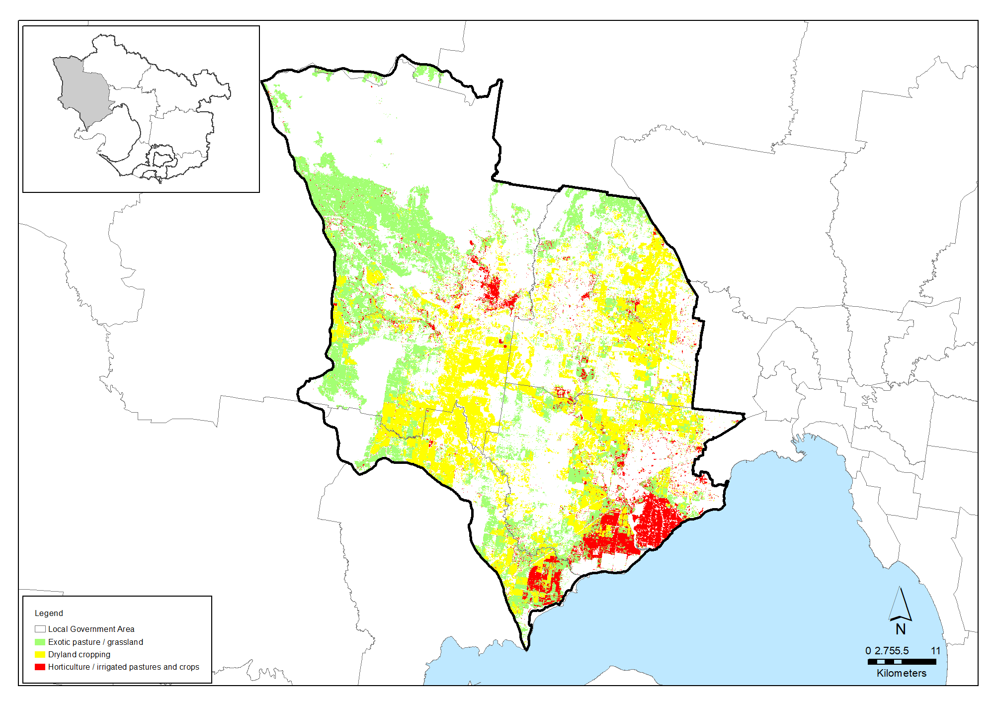
Agriculture remains strong in the Moorabool, Melton, Wyndham & Greater Geelong area. It occupies 103,800 hectares (41%) of the land. Commodities valued at $207 million were produced by 588 enterprises in 2015-16.
The largest part of this productivity is from fresh vegetables grown on alluvial soils in the Werribee South and Bacchus Marsh irrigation districts. Vegetables with a gross value of $98 million were produced on 3,400 hectares at Werribee in 2015-2016. Clay loam soils, groundwater and the possibility of reused water from the Western Treatment Plant are the Werribee horticulture industry’s critical foundations.
The rural land west of the Urban Growth Boundary is used for cattle and sheep grazing where pastures have been improved. Meat and livestock worth $12 million were produced in the City of Melton area in 2015-2016.
| Agriculture data from 2015-16 | Moorabool, Melton, Wyndham & Greater Geelong area |
|---|---|
| Area of Melton, Moorabool, Wyndham & Greater Geelong (Hectares) | 251,541 |
| Area of agriculture (Hectares) | 103,851 (41%) |
| Number of farms | 588 |
| Employment on farms | 2,277 |
| Gross value of annual agricultural production ($) | $207 million |
| Main agricultural commodities | Grains, sheep meat and wool, poultry, pork, vegetables |
Cereal cropping, including high quality malting barley and hay are also major farm products on the Werribee plains where soils have been cleared of their characteristic volcanic boulders. Other parts of the volcanic plains offer relatively poor returns where low rainfall and heavy clay soils laden with volcanic rocks hamper cultivation or pasture improvement.
Groundwater from the Deutgam Groundwater Management Unit is a major agricultural resource in the Werribee horticulture area. 796 megalitres were extracted from the aquifer in 2018-19; well below the licensed limit of 5,100 megalitres. This water is estimated to have supported production valued at $2.5 million in that year.
Soil health
Over the whole area, the proportion of exposed soil has ranged between 10% and 20% from 2000 to 2020, as shown in the graph below. This indicates that most of the land remains covered and protected by vegetation (including pasture) at all times. However, there are some years when a higher proportion of land is exposed and at risk of broad scale erosion.
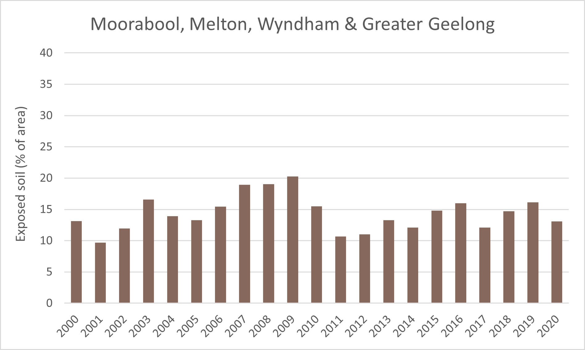
Proportion of exposed soils for the area from 2000 to 2020 (data from Australian National University)
Biodiversity
Native vegetation covers about 133,517 hectares or 53% of the Moorabool, Melton, Wyndham & Greater Geelong area.
Natural temperate grassland and grassy eucalypt woodland are the area’s most significant and threatened ecological communities. Less than 5% of these communities remain across Victoria. They are among the most threatened ecosystems in Victoria and the most under-represented in conservation reserves. Weeds, feral animals and loss of native species continue to undermine their ecological functions.
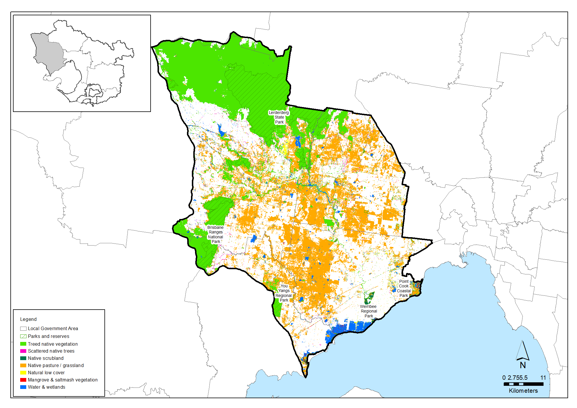
The contiguous Lerderderg State Park and Wombat State Forest comprise 84% of conservation reserves in the Moorabool Melton Wyndham Greater Geelong area. Only 4.2% of the rest of the area holds relatively intact habitat. Virtually none of this is native grassland – the area’s most threatened vegetation type.
The creation of a new 14,400 hectare Western Grasslands Reserve aims to fill this gap. The plan, set in 2010 to meet the requirements of the EPBC Act, aimed to offset the loss of grasslands to suburban development by purchasing relatively high quality grassland on private land to the west. However, these land purchases and the establishment of the park have been delayed.
| Lerderderg State Park | 20,500 hectares | Wombat State Forest | 25,500 hectares |
| Long Forest Flora & Fauna Reserve | 600 hectares | Werribee Gorge State Park | 564 hectares |
| Brisbane Ranges National Park | 4,400 hectares | You Yangs Regional Park | 1,176 hectares |
| The Spit Wildlife Reserve | 677 hectares | Werribee and Point Cook Coastal Parks | 800 hectares |
Nature conservation reserves managed by the four councils are additional and valued patches of native vegetation. Most are relatively small and scattered across cleared landscapes and along waterways. They are potential ‘stepping stones’ in revegetation projects to improve habitat connectivity. The City of Wyndham manages 200 hectares of reserves and 200 kilometres of roadside for their biodiversity values. The City of Melton manages 100 conservation reserves.
Hundreds of wetlands dot the volcanic plains along watercourses and in depressions and breaks in the basalt bedrock. Most wetlands are in poor condition but many hold scarce biodiversity values. Coastal wetlands in the City of Wyndham and Greater Geelong are of national significance. Forty-four threatened bird species have been recorded in or in the immediate surrounds of the Point Cook marine Wetland Sanctuary. Some State and Local Government reports and strategies provide lists of threatened species and the City of Melton website says 170 bird species live in its local government area. The Healthy Waterways Strategy 2018-28 reports:
- 350 riparian bird species are found in the Werribee catchment
- Nationally-significant fish including the Australian grayling in the lower Werribee River
- Frog species such as the growling grass frog, Bibron’s toadlet and the southern toadlet (neither toadlet species has been recorded in the catchment since the millennium drought)
- Platypus in parts of the Werribee and Lerderderg Rivers with reliable summer flows.
A picture of decline in native animal species in response to habitat loss, pest predation and other factors is indicated in an analysis of animal sighting data that calculated the probability that each species of native birds, mammals, amphibians, reptiles and fish was persisting at the end of 2016.
The analysis indicated that, for the Moorabool, Melton, Wyndham & Greater Geelong area, only around 78% of the total number of species recorded here are still persisting. In general, the diversity of native fish and reptile species seem to been most affected.
| Native species | Number and proportion of species likely to be persisting (at 2016) |
|---|---|
| Birds | 284/337 (84%) |
| Mammals | 33/41 (80%) |
| Amphibians | 10/13 (77%) |
| Reptiles | 18/34 (53%) |
| Fish | 4/20 (20%) |
| Total | 349/445 (78%) |
Threatened species are considered to be priorities for local protection and recovery work. In many circumstances, work to protect and enhance their health and resilience will also benefit other native animal species and the local habitat. The following table shows some of the threatened species and ecological communities that have been recorded in this area. A full list of the threatened species known to occur in this region since 1980 is available at the Data tables section of this strategy.
Threatened species known to occur in the Moorabool, Melton, Wyndham & Greater Geelong area
| Group | Species |
|---|---|
| Birds | Australasian Bittern, Australian Little Bittern, Australian Painted Snipe, Barking Owl, Bar-tailed Godwit, Black Falcon, Blue-billed Duck, Brolga, Caspian Tern, Crested Bellbird, Curlew Sandpiper, Diamond Firetail, Eastern Curlew, Eastern Great Egret, Fairy Tern, Freckled Duck, Great Knot, Grey Goshawk , Hooded Plover, Lewin's Rail, Little Egret, Little Tern, Magpie Goose, Major Mitchell's Cockatoo, Orange Bellied Parrot, Painted Honeyeater, Plains-wanderer, Plumed Egret, Powerful Owl, Red Knot, Red-chested Button-quail, Speckled Warbler, Swift Parrot, White-bellied Sea-Eagle, White-throated Needletail |
| Mammals | Eastern Bent Winged Bat, Brush-tailed Phascogale, Greater Glider, Grey-headed Flying-fox, Platypus |
| Reptiles | Striped Legless Lizard, Lace Monitor, Tussock Skink |
| Amphibians | Brown Toadlet, Growling Grass Frog, Southern Toadlet |
| Fish | Freshwater Catfish |
| Invertebrates | Golden Sun Moth |
| Flora | Bacchus Marsh Wattle, Brittle Greenhood, Buloke, Button Wrinklewort, Clover Glycine, Large-headed Fireweed, Matted Flax-lily, Narrow Goodenia, Plains Rice-flower, Purple Swamp Wallaby-grass, Silver Gum, Small golden moths orchid, Small Milkwort, Small Scurf-pea, Spiny Rice-flower, Tough Scurf-pea, Velvet Daisy-bush |
| Ecological communities | Grassy Eucalypt Woodland of the Victorian Volcanic Plain, Grey Box (Eucalyptus microcarpa) Grassy Woodlands and Derived Native Grasslands of South-eastern Australia, Natural Temperate Grassland of the Victorian Volcanic Plain, Seasonal Herbaceous Wetlands (Freshwater) of the Temperate Lowland Plains, Subtropical and Temperate Coastal Saltmarsh, White Box-Yellow Box-Blakely's Red Gum Grassy Woodland and Derived Native Grassland, Grey Box - Buloke Grassy Woodland Community, Rocky Chenopod Open Scrub, Western (Basalt) Plains Grasslands, Western Basalt Plains (River Red Gum) Grassy Woodland |
Waterways
The Little River, Werribee River, Lerderderg River and Toolern Creek are the Moorabool, Melton, Wyndham & Greater Geelong area’s significant waterways. All drain into the northwest part of Port Phillip Bay. The Pykes Creek Reservoir near Myrniong stores water from the Werribee River headwaters for farmers in the Bacchus Marsh and Werribee Irrigation Districts.
Rivers and wetland conditions and conservation strategy for the Moorabool Melton Wyndham Greater Geelong area are described in the Werribee catchment chapter of the Healthy Waterways Strategy 2018-28. Waterway values and conditions are variable from low to high across the Werribee catchment. Similar, but generally lower, assessments are made for wetlands in the Werribee catchment.
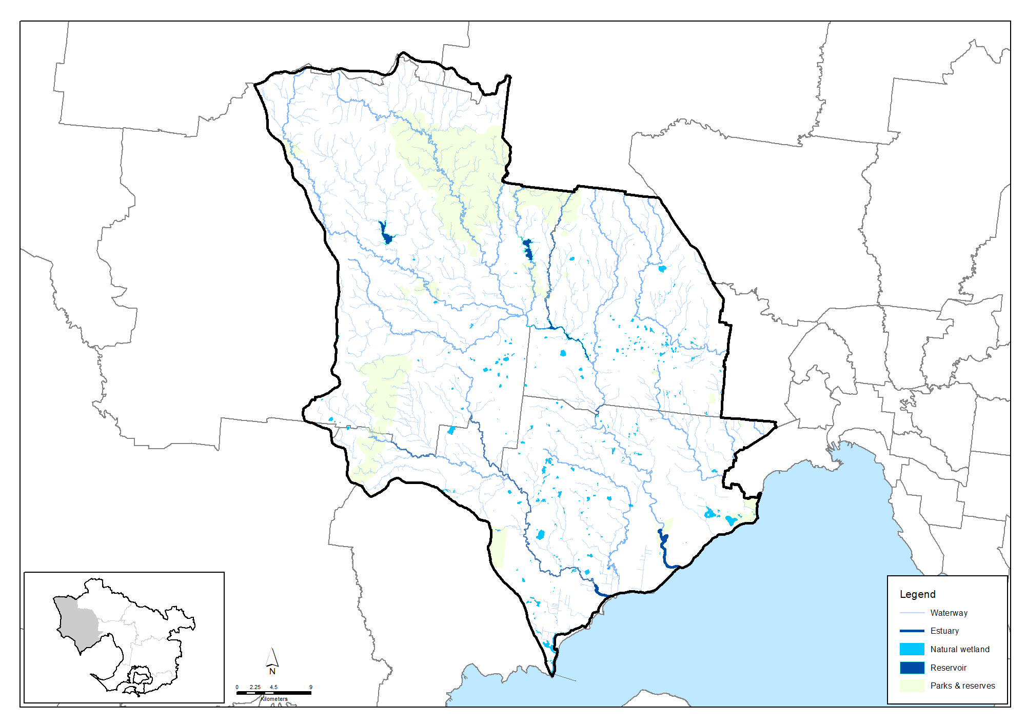
The best stream conditions are found in the forested reaches of the upper Lerderderg and Werribee Rivers. The environmental and landscape values of the upper Lerderderg are recognised in its listing under the Heritage Rivers Act 1992. The value of vegetation across other parts of the catchment is of low to moderate value as a result of the modified nature of the catchment.
There have been recent records of nationally-significant fish including the Australian grayling in the lower Werribee River. Frog species include threatened species such as the growling grass frog, Bibron’s toadlet and the southern toadlet; although neither of the two toadlet species have been recorded in the catchment since the Millennium Drought. There are 134 expected riparian bird species.
Platypus are distributed in those parts of the Werribee River system (including Lerderderg River) that have reliable summer flow regimes. However, they are considered to be locally threatened due to low numbers and continuing long-term decline.
Assessment of waterway values and conditions in the Werribee catchment at 2018 (from the Healthy Waterways Strategy)
| Waterway values | 2018 state | 2018 trajectory | 2068 target |
|---|---|---|---|
| Birds | Moderate | Low | Moderate |
| Fish | Low | Low | Moderate |
| Frogs | Moderate | Low | Moderate |
| Macroinvertebrates | Moderate | Moderate | Very high |
| Platypus | Low | Very low | Low |
| Vegetation | Moderate | Low | Moderate |
| Amenity | High | Moderate | High |
| Community connection | High | Moderate | Very high |
| Recreation | High | High | High |
| Waterway conditions | 2018 state | 2018 trajectory | 2068 target |
|---|---|---|---|
| Stormwater | High | High | High |
| Physical form | Moderate | Moderate | High |
| Water for the environment | High | Moderate | High |
| Vegetation quality | Low | Low | Moderate |
| Vegetation extent | Moderate | Moderate | High |
| Instream connectivity | Low | Low | High |
| Water quality - environment | Moderate | Low | Moderate |
| Access | Very low | Very low | Low |
| Litter | High | Moderate | High |
| Water quality - recreational | High | High | High |
| Participation | Moderate | Moderate | Very high |
Community action
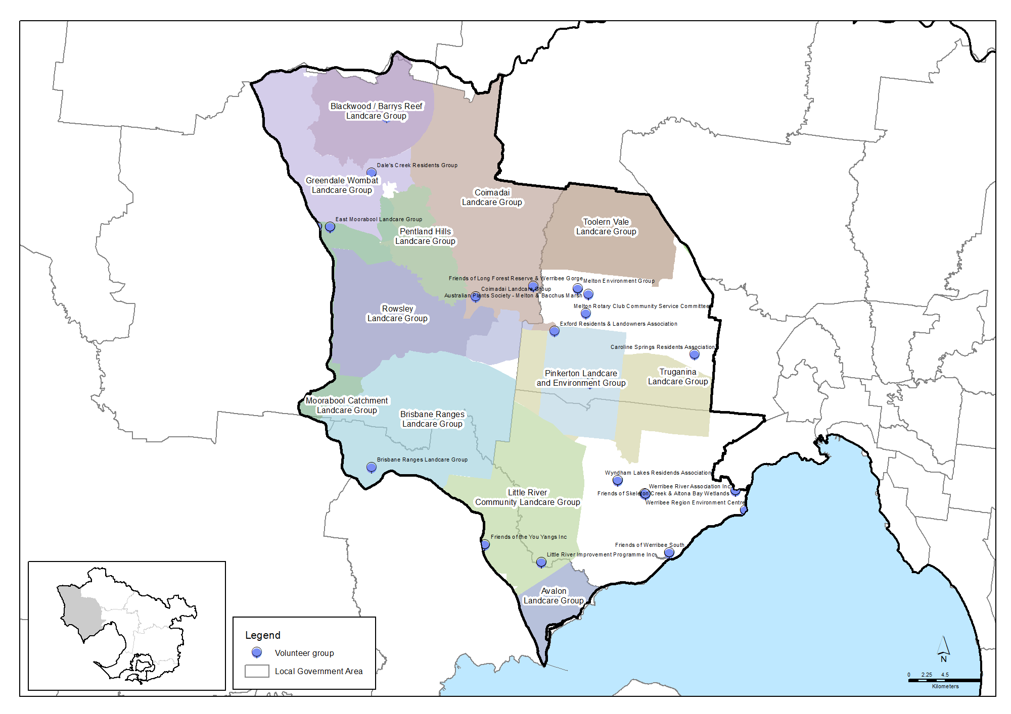
There is a vibrant Landcare movement across the Moorabool, Melton, Wyndham & Greater Geelong area. There are 14 active Landcare Groups and two Landcare Networks. Based on data from a 2019 survey, it is estimated that the groups and networks collectively have around 658 members and volunteer around 14,066 hours per year for Landcare activities that benefit the environment, landscapes and community. This volunteering is worth in the order of $474,165 per year.
Grow West is one of Australia’s most ambitious landscape restoration programs. Since 2003, this collaboration between numerous organisations and landholders has taken huge strides to rejuvenate 10,000 hectares of land in the Upper Werribee Catchment.
Trust for Nature and Land for Wildlife properties also underline community commitment to conservation in the rural parts of the area.
Community volunteers are also active in numerous Friends groups, Committees of Management and other volunteer organisations across the sub-region. There are an estimated 23 organisations providing 436,227 volunteer hours worth $1,221,212 per year.
More detail is in the Community volunteering data table.
Challenges we face
Climate change, population pressures and urbanisation are major challenges to the future health of environments in the Moorabool, Melton, Wyndham & Greater Geelong area.
Climate change
The Climate Change in the Port Phillip & Western Port Region report identifies risks and responses to warmer, drier conditions and rising sea levels across the region. The most climate-sensitive and affected environmental assets in the Moorabool, Melton Wyndham & Greater Geelong area are predicted to be:
- Large areas of native vegetation in the Brisbane Ranges National Park and the You Yangs, Werribee Gorge and Lerderderg Regional and State Parks. Native vegetation in the north-south corridor from Lerderderg State Park to Long Forest Fauna and Flora Reserve.
- The upper reaches of the Werribee River and its tributaries south of the Great Divide to Bacchus Marsh and Melton.
- Numerous freshwater wetlands, particularly across the volcanic plains and coastal wetlands at Point Cook.
- Soils across the north-western third of the region, particularly west of the Rowsley Fault where soils occur on steeper slopes and where increased wind and water erosion risk is created under climate-induced vegetation loss and more frequent intense fire.
- Soils on the coast near Little River may be made sensitive to saltwater flooding by rising sea levels.
Climate Risk Assessments developed by the three Local Government-based Alliances for Greenhouse Action, the Eastern Alliance, the Northern Alliance and the Western Alliance find:
- Vulnerability to climate change is compounded for newly arrived migrants, the aged and young children and people living in relative poverty, in sub-standard housing or with poor English
- Lack of understanding of local flora and fauna species responses to climate change is hampering timely and effective investment and action for biodiversity conservation
- Social and policy pressures for larger fire breaks and more fuel-reduction burning is impacting biodiversity and air quality
- Changing wildfire frequency and intensity in warmer, drier conditions is damaging biodiversity and increasing demands for fire-management effort
- Fire agency management planning often conflicts with the environmental protection goals and targets of local, regional and state environment strategies.
Urban ‘heat island’ effect is recognised as a major climate change stress in the urban areas of Melton and Wyndham. Natural tree cover on the volcanic plains was only significant in sheltered gullies and in the shallow gorges along watercourses. This natural landscape and past urban designs have left Melton and Wyndham suburbs with the lowest areas of tree canopy cover in the region.
Large-scale plantings of new vegetation to sequester carbon will be best placed where they can also achieve biodiversity benefits in the local landscapes including increased connectedness of native habitat. In addition, the coastal vegetation and soils on the western shoreline of Port Phillip Bay are considered to hold significant stores of carbon. It is therefore a very high priority to protect these ‘blue carbon’ stores through activities such as fencing, management of pests and overuse to ensure vegetation extent and quality are maintained.
Urbanisation
The area is home to two of Australia’s fastest growing municipalities – Wyndham and Melton. Population forecasts for the Moorabool, Melton, Wyndham & Greater Geelong area predict growth of 80% over the next 20 years – from 517,300 residents in 2021 to 934,400 in 2041. This population will live in 317,000 dwellings – more than double the area’s 2016 urban footprint.
Urban development brings:
- demands for space, facilities, transport infrastructure and access to recreation areas
- damage from illegal clearing, vehicle tracks, vandalism, feral animals, firewood collection and rubbish dumping
- Altered stream flows and water pollution from increased hard-surface run-off
- Waterways habitats damaged by flood protection works and sediment inputs
- Barriers to animal movement created by roads and infrastructure
- Continuing habitat damage from recreation, vandalism, informal vehicle tracks and rubbish
- Continued clearing for buildings, fences, access, views etc.
- Feral domestic animals
- Pest plants and plant diseases such as Phytophthora cinnamoni spread by humans, birds and animals and from dumped garden waste
Green Wedge protection
Preserving Melbourne’s Green Wedges, rural and semi-rural land outside the Urban Growth Boundary, is likely to cause ongoing social, economic and political tension. Urban and rural land uses and priorities, residential amenity and farm business activities often conflict at Green Wedge boundaries.
Farming becomes more difficult and economically challenging as new suburbs butt up against farm fences. Selling and subdividing peri-urban farmland can make cash-poor farmers into overnight millionaires and many see few better options than this ‘last harvest’. Land just outside the Urban Growth Boundary is often left vacant or poorly managed in ‘land banks’ as owners await and/or lobby for rezoning and subdivision.
Victorian Government policy is to protect Green Wedges from urban development and inappropriate uses. Persistent commitment to this policy will be needed from local councils, State Government and its agencies to protect it from gradual erosion through piecemeal exemptions.
Pest plants and environmental weeds
Pest plants and environmental weeds are a major threat to the area’s natural environment. Once established, they grow vigorously because they have few natural predators or diseases to control them. They change and destroy habitats and ecosystems, outcompeting indigenous plants for light, nutrients and water. This leaves our wildlife without food and habitat, leading to the decline of our native animals.
Many pest plants are spread from domestic gardens. Seeds are spread by birds and animals or by people dumping garden cuttings into our bush and waterways.
Pest animals and predators
The introduction of exotic plants and animals has had significant consequences for the area’s native animal and plant species. Pest animals significantly impact on native plants and animals and their habitats. Foxes and cats, in particular, are exceptional hunters and are the primary cause of the decline and extinction of many smaller native animals.
Other pest animals including rabbits directly compete with native wildlife for food and shelter, damage native vegetation and degrade the land, while introduced fish species compete for food and prey on native fish, tadpoles and frogs.
Changing fire regimes, frequency and intensity
Traditional Owners have used fire as an ecological management tool for more than 40,000 years, understanding that Australian plant and animal communities rely on ‘regimes’ of fire intensity, frequency, season, extent and type to regenerate and maintain health and diversity. Fire regimes create food, shelter and breeding sites for native animals.
Changing fire regimes caused by climate change and human intervention through the 20th Century means some native plant and animal communities have been unnaturally insulated from fire, while others have been exposed to more frequent burning.
A drier future climate will increase the likelihood more frequent and severe wildfire, like those experienced across south east Australia in the summer of 2019-20 where an estimated 1 billion native animals were killed.
Incremental damage and clearing of native vegetation
Incremental damage to the area’s native vegetation has been caused by illegal clearing, vandalism, informal vehicle tracks, firewood collection and rubbish dumping. Clearing at the edges of remnant patches and of individual trees is expected to continue. Some losses will prompted by wildfire control.
The successful establishment of the Western Grasslands Reserve is critical to offset grasslands loss under residential development in the Western Growth Corridor.
Native vegetation loss across the Moorabool Melton Wyndham Greater Geelong area is likely to continue species decline. The 2004 biodiversity study, How much habitat is enough? showed that landscapes with less than 15% vegetation cover may support diverse but low populations of native plant and animal species, but their future is not assured. The study recommends that increasing vegetation cover above 15% could be an intermediate revegetation goal while 35% cover should be a goal where practicable.
Supporting Wadawurrung, Wurundjeri Woi-wurrung and Bunurong connection with Country
There is a challenge to strengthen the role and influence of traditional ecological knowledge and practices in today’s natural resource management programs, where that is allowed and offered by Traditional Owners.
There are currently relatively few Aboriginal people who have jobs taking care of Country in this region, with the exception of some outstanding examples such as the Wurundjeri Narrap Team. There is a challenge in providing timely, tailored support for Registered Aboriginal Parties and other Aboriginal organisations so they can determine their aspirations and build their workforce to suit their aims with the appropriate range of skills.
Traditional Owners’ rights to water have largely been excluded from water planning and management policies and programs. Without water rights, Traditional Owners are unable to decide where or how water can be used to support cultural, spiritual, environmental or economic outcomes. There is an opportunity to address this in water planning and securing water allocations for Registered Aboriginal Parties to enable cultural watering.
Policy and planning
A range of policies and plans are in place to protect and enhance the area’s cultural, social, environmental and economic values and address the challenges that lie ahead.
Plan Melbourne 2017-2050 is the main integrated land-use, infrastructure and transport plan published by the Victorian Government. It aims to support economic growth and protect liveability and sustainability across metropolitan Melbourne. As part of its implementation, Land Use Framework Plans are being developed to guide strategic land-use and infrastructure development for the next 30 years for six metropolitan Melbourne regions including the Western region (comprising the Brimbank, Hobsons Bay, Maribyrnong, Melton, Moonee Valley and Wyndham Local Government Areas).
For Melbourne’s urban growth areas, the Victorian Planning Authority manages the development of Precinct Structure Plans (PSPs) which are master plans for local areas that usually cater for between 5,000 to 30,000 people, 2,000 to 10,000 jobs or a combination of both. PSPs provide more specific detail regarding how existing important features of local communities such as roads, shopping centres, schools, parks, key transport connections and areas for housing and employment may evolve or transform over time and become better integrated.
The management of land, water and biodiversity in the Moorabool, Melton, Wyndham & Greater Geelong area is principally overseen by its four councils, Melbourne Water, Parks Victoria, the Department of Energy, Environment and Climate Action and EPA Victoria along with landholders and other authorities, organisations and community groups. The area’s significant strategies and plans include the:
- Wyndham 2040 Vision
- Wyndham Environment & Sustainability Strategy 2016-2040
- Wyndham Coastal & Marine Management Plan 2020-2025
- Wyndham City Forest and Habitat Strategy 2017-2040
- Wyndham Open Space Strategy 2045
- Moorabool Shire Council Plan 2021-2025
- City of Melton Environment Plan 2017–2027
- City of Greater Geelong Environment Strategy 2020–30
- Healthy Waterways Strategy which provides vision statements, goals and 10 and 50-year targets for waterway management in each of the region’s catchments
- Protecting Victoria’s Environment – Biodiversity 2037 – the Victorian Government’s state-wide strategy to arrest biodiversity decline.
Climate Risk Assessments have been developed by the three Local Government-based Alliances for Greenhouse Action, the Eastern Alliance, the Northern Alliance and the Western Alliance.
Traditional Owners are the voice of their Country
For all policy and planning, there is a need for recognition and inclusion of Traditional Owner knowledge and aspirations. The waterways and lands are increasingly being recognised as ‘living and integrated natural entities‘ and the Traditional Owners should be recognised as the ‘voice of these living entities’.
The Wadawurrung Traditional Owners Country Plan articulates how Wadawurrung see Country being cared for and managed over the next 10 years. “This includes walking together with governments and other stakeholders to achieve self-determination and ensure sustainable Wadawurrung managed investment in Country”.
Country Plans are also being prepared by the Bunurong Land Council Aboriginal Corporation and the Wurundjeri Woi-wurrung Cultural Heritage Aboriginal Corporation and will describe the vision and priorities of the Traditional Owners for Country under their roles as Registered Aboriginal Parties.
The Country Plans will provide a strong basis for all planning to recognise and include the voices of these Traditional Owners.
Vision and targets for the future
Vision
The Traditional Owners of this area, the Wadawurrung, Wurundjeri and Bunurong people, have cared for this Country for thousands of years, and have these visions for its future:
Wadawurrung
All people working together to make Wadawurrung Country and Culture strong.
Wurundjeri
To be added in line with Wurundjeri Woi-wurrung Country plan (in preparation).
Bunurong
To be added in line with Bunurong Country plan (in preparation).
The Paleert Tjaara Dja – Let’s make Country good together 2020-2030 – Wadawurrung Country Plan includes the following targets:
- By 2025, 70% of Wadawurrung Traditional Owners have strong cultural connection and knowledge, we are practicing culture and speaking language
- By 2029 Wadawurrung people are involved in the management of all known (cultural heritage) sites
- By 2030, 60% of Wadawurrung people who want to work on Country have jobs or businesses
- By 2030, there is enough of Wadawurrung People’s favourite bush tucker
- By 2030, there is enough water in the waterways of Barre Warre Yulluk that it flows through the system, without barriers and is clean enough to drink
- By 2030, the current extent of volcanic grass lands and woodlands is increased by 5%
- By 2029, native vegetation extent (on Coastal Country) remains or increases and cultural places are protected
- By 2030, the Warre (sea) life in species, the seaweed and water quality remains at 2020 numbers and levels
- By 2030, no more of our native animals have become threatened
- By 2035,at least one threatened species is no longer threatened.
The Wyndham City Environment & Sustainability Strategy 2016-2040 has the following vision and targets for land, water and biodiversity:
Wyndham is renowned for its unique and iconic natural environment. As a community, Wyndham has embraced renewable energy, waste and water conservation practices and is committed to combatting climate change
- No loss of area protected by ESOs in Wyndham and all ESOs retain significant environmental values
- All development in Wyndham is consistent with the Wyndham ESD Policy and compliance is monitored
- No expansion to the 2015 Urban Growth Boundary
- All recommendations of the Wyndham Habitat Plan have been implemented and the plan has been reviewed and updated
- At least 25% tree canopy cover within urban public open space
- Ensure coastal natural assets are protected and maintained with no encroachment on the green wedge zone
- Wyndham coastline remains undeveloped
- All private rural land is actively managed by landowners for noxious and highly invasive weeds
- All significant flora and fauna species in Council conservation reserves to have a conservation action plan
- No decline in conservation rating of locally indigenous species
- The Western Grassland Reserve is fully established and functioning as a grassland national park
- The Werribee River, Little River and Skeleton Creek are healthy, functioning waterways providing high quality habitat for native species
The Wyndham Coastal & Marine Management Plan has the following vision and aims:
To connect and enhance the unique qualities of the Wyndham coastline for greater access and enjoyment and to facilitate appropriate coastal development and tourism
- Maintain and enhance native vegetation habitat and biodiversity
- Apply ecosystem-based management to create and maintain (healthy coastal environments)
- Support the long-term use and development of the (coastal) agricultural precinct for high intensity agriculture
- Ensure that the coastal environment meets the needs of the majority of users
- Remove private encroachments onto Crown land
- Support community groups developing and delivering foreshore programs
- Increase access to natural and wild places for all people to enjoy and recreate
- Protect against adverse environmental impacts, and respond to anticipated sea level rises, storm surge events and higher tides.
The City of Melton Environment Plan 2017–2027 has the following vision and objectives for land and biodiversity:
In 2036, the City of Melton is a clean, green, sustainable city that meets the needs of its current and future population while valuing and protecting its unique environmental assets. Melton City Council is accountable for its environmental impacts and leads by example, supporting an environmentally aware and engaged community
- Establish a whole of organisation approach for biodiversity management
- Improve mapping and understanding of flora and fauna in the municipality
- Continue to manage Council’s conservation reserves in accordance with best practice conservation and land management practices
- Continue to support local landholders as primary agents in managing rural land to reduce the impacts of weeds, feral animals and soil erosion
- Increase community capacity, knowledge and understanding of sustainable land management practices.
The Moorabool Shire Council Plan 2021-2025 vision is:
Embracing our natural environment and lifestyle options to create an inspiring place for everyone to live, work and play
The plan includes a goal for “Liveable and thriving environments” to develop a Sustainable Environment Strategy.
The City of Greater Geelong Environment Strategy 2020–30 vision and targets for biodiversity are:
By 2047, Greater Geelong will be internationally recognised as a clever and creative city-region that is forward looking, enterprising and adaptive, and cares for its people and environment
- Establish conservation protection for all remnant biodiversity patches larger than 10 hectares by 2025
- Establish an additional 1,000 hectares of protected natural habitat by 2030
- Engage 100,000 people in nature education and conservation activities by 2025
- Review and update our Biodiversity Strategy by 2021
- Prevent any new indigenous species or habitat area extinctions during the term of this strategy
- Achieve a net gain of biodiversity within Greater Geelong during the term of this strategy.
Regional Catchment Strategy targets
The following long-term targets for the Moorabool, Melton, Wyndham & Greater Geelong area (at the year 2050 or further) reflect the region-scale vision of the Regional Catchment Strategy and the visions and directions of the local councils, the Healthy Waterways Strategy, other plans and the community. Achievement of these targets will help ensure this area remains healthy for future generations. In some cases, the targets are the local contribution towards achieving whole-of-region targets outlined in the ‘Themes‘ section of this Regional Catchment Strategy.


Partner organisations for the journey ahead
The following organisations formally support the pursuit of the Regional Catchment Strategy’s targets for the Moorabool, Melton, Wyndham and Greater Geelong area. They have agreed to provide leadership and support to help achieve optimum results with their available resources, in ways such as:
- Fostering partnerships and sharing knowledge, experiences and information with other organisations and the community
- Seeking and securing resources for the area and undertaking work that will contribute to achieving the visions and targets
- Assisting with monitoring and reporting on the condition of the area.
Traditional Owners
- Wadawurrung Traditional Owners Aboriginal Corporation
- Bunurong Land Council Aboriginal Corporation
Local Government
- Wyndham City
- Moorabool Shire Council
- City of Greater Geelong
- Western Alliance for Greenhouse Action
Community
- NatureWest
- Little River Community Landcare Inc
- Werribee River Association
Victorian Government
- Department of Energy, Environment and Climate Action
- Melbourne Water
- Parks Victoria
- Sustainability Victoria
- Zoos Victoria
- Victorian Planning Authority
- Environment Protection Authority Victoria (EPA)
- Victorian Fisheries Authority
- Trust for Nature
- Victorian Environmental Water Holder
Non Government
- Mt Rothwell Biodiversity Centre / Odonata
- The Nature Conservancy
- Birdlife Australia
- Gardens for Wildlife Victoria
- Field Naturalists Club of Victoria
- Conservation Volunteers Australia
- Native Fish Australia (Vic)
- OzFish Unlimited
- The People and Parks Foundation
- Habitat Restoration Fund
Add your organisation as a supporter and partner
If your organisation supports these directions and targets for Moorabool, Melton, Wyndham & Greater Geelong, you can request to be listed as a partner organisation. Adding your organisation to this list will:
- enable your organisation to list one or more priority projects in the Prospectus which will describe how your priority project will pursue the targets of this Regional Catchment Strategy and potentially make your organisation’s project more attractive to investors by using the strategy to highlight its relevance and value
- demonstrate your commitment to a healthy and sustainable environment
- demonstrate the level of community engagement and support for this work.
Priority projects to move forward
Priority projects
There are significant ongoing programs and initiatives undertaken by many organisations that are vital for the management of natural resources and the support of communities in the Moorabool, Melton, Wyndham & Greater Geelong area. In addition, there are numerous project proposals that, if funded and implemented, can contribute to achieving the Regional Catchment Strategy’s visions and targets for the area. They include projects that:
- Establish new vegetation in large-scale, strategic locations where it provides multiple benefits by contributing to carbon sequestration, habitat restoration and habitat connectivity
- Help achieve net gain in the extent and condition of habitat across public and private land, coasts and waterways
- Protect the waterways of the west and the coastal wetlands
- Protect threatened species
- Support soil health and the adoption of sustainable agriculture practices
- Support resilience to climate change in agricultural enterprises and communities
- Increase community participation, engagement, education and enjoyment in nature and conservation
- Strengthen Traditional Owners roles in environmental decision-making and action.
Project proposals include:
- Werribee water supply reconfiguration led by Greater Western Water and the Department of Energy, Environment and Climate Action (DEECA)
- West Werribee recycled water scheme expansion led by Greater Western Water
- Western Irrigation Network led by Greater Western Water
- Improving environmental flows for the Werribee River led by Greater Western Water
- Reimagining Arnolds Creek led by Melbourne Water
- Western Grasslands Reserve Program led by Parks Victoria
- Pyrete Ranges to Long Forest Biolink proposed by Melbourne Water
- Connecting the Dots – Buloke Protection proposed by Melbourne Water
- Biolinks for the Brush-tailed Phascogale proposed by Melbourne Water
- The Spit saltmarsh restoration proposed Melbourne Water
- Peaks to Plains: Enhancing the You Yangs and grasslands proposed by Melbourne Water
- Significant plants of the Brisbane Ranges proposed by Melbourne Water
- Farming on the margins proposed by Melbourne Water
- Greening the Pipeline led by Melbourne Water
- Lower Werribee Cultural Values Assessment proposed by Melbourne Water
- Little River Weir improvement proposed by Little River Community Landcare Inc
- Skeleton Mudflats Reserve – Regeneration led by NatureWest
- Werribee – Little River Biosites Restoration proposed by NatureWest.
A list of project proposals and their key details can be viewed and sorted on the Prospectus section of this website.
Propose a new priority project
As part of the ongoing development and refinement of this Regional Catchment Strategy, additional priority projects may be considered for inclusion in the Prospectus.
If your organisation supports the directions and targets for this area, and has a project it would like highlighted and supported in this Regional Catchment Strategy, please submit a Prospectus Project Proposal.