Creating a new 4.5 hectare wetland system in Melbourne’s south east
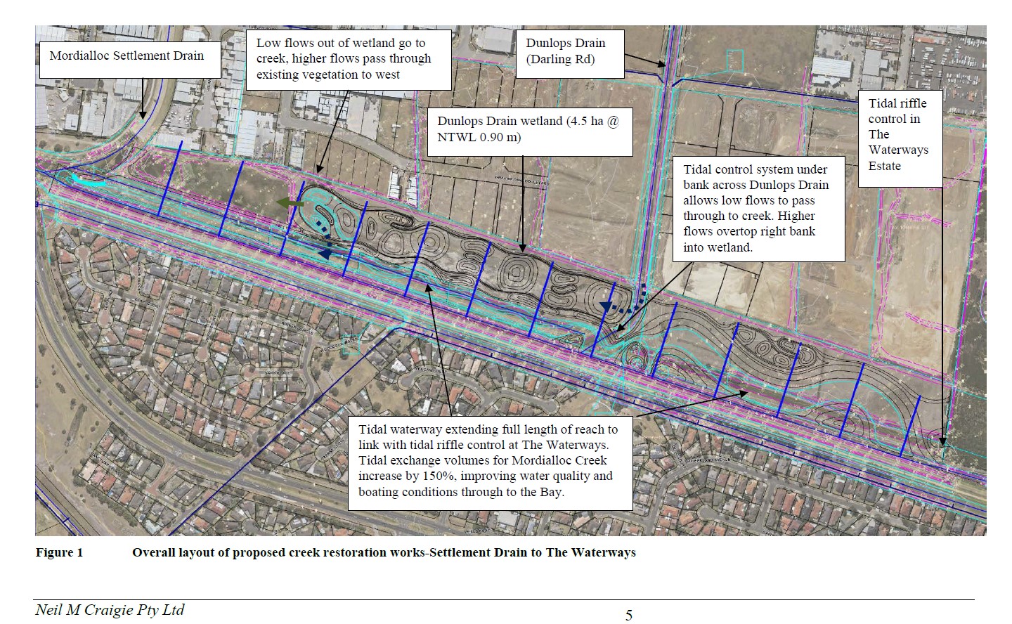
The project will involve the construction of a naturalised wetland system of approximately 4.5ha. The wetlands will be located approximately 30 kilometres to the south-east of Melbourne’s CBD. The wetlands will outlet into Port Phillip Bay, approximately 2 kilometres away.
Traditionally, almost all the land at this location was subject to shallow flooding from Mordialloc Creek. The Dandenong Valley Authority (DVA) in the 1970’s began to remedy this issue through allowing the northern areas of land within the region to be subdivided, and by allowing both widening and deepening of Mordialloc Creek (to offset flood storage loss).
The wetlands will extend approximately 1,300 metres along the creek upstream of the Mordialloc Settlement Drain and will improve the current narrow, straight-cut channel to a naturalised wetland system.
The wetland system is expected to remove approximately 1.9 tonnes of nitrogen annually entering Mordialloc Creek, which ultimately outfalls into Port Phillip Bay. The source of this load comes from Dunlop’s Drain, from the upstream existing industrial/mixed use catchment, and from water entering the site from the east.
The wetlands present an opportunity to achieve multiple community benefits. These Include; facilitating development, improvement in existing waterway condition and health, and providing additional stormwater treatment capacity.
Themes and Local Areas
| Primary Theme: | Wetlands |
| Other Themes: | Waterways, Native vegetation, Native animals, Coasts, Estuaries, Marine Environments |
| Primary Local Area: | Urban Melbourne |
| Other Local Areas: | Port Phillip Bay |
| Project location: | Location of the wetlands: Land south of Canterbury Road, Braeside VIC 3195 and adjacent Mordialloc Creek. Melway: 93 A2 |
| Scale of the project: | Local |
| New or continuing work: | New work |
Project partners
| Lead organisation: | Melbourne Water |
| Key partners: | This project would potentially be delivered in a partnership with Melbourne Water and Kingston City Council, utilising numerous funding streams to achieve multiple benefits. There would be potential to have community involvement through community planting days. There is a very high level of community interest in seeing the project delivered. |
| Registered Aboriginal Party/s relevant to the project or its area: | Bunurong Land Council Aboriginal Corporation |
Investment opportunities
| Opportunities for investors within this project start from: | $$$ (Hundreds of thousands of dollars) |
| Estimated scale of investment for full project implementation: | $$$$ (Millions of dollars) |
| Estimated timeframe for full project implementation: | 2-10 years |
Contribution toward targets
| Primary Regional Catchment Strategy target: | Target 3.3 Wetlands water quality and 12.1: Marine Water Quality: Water quality in waterways and bays is improved by reducing inputs of sediment and other pollutants from urban construction and development. The new wetland system is expected to remove approximately 1.9 tonnes of nitrogen annually entering Mordialloc Creek which would otherwise outfall into Port Phillip Bay untreated which is approximately 2kms away. As well as nitrogen reduction, the wetland would remove 560 tonnes of sediment each year from entering Port Phillip Bay. Target 2.2 Waterway amenity: Mordialloc Creek provides the backdrop to a range of recreational, social and cultural activity. The site of proposed works is located in an area of public use and also proximate to a shared path network. This project will boost the creek’s amenity through improving creek health, native vegetation, habitat for wildlife and visual aesthetics for users of the area. 550 households in Aspendale Gardens on the south side of Mordialloc Creek form the audience for the Mordialloc Creek Aspendale Gardens Residents Association (AGRA). The AGRA has been involved in early discussion of the project, and have given the project praised support. There is significant interest from the public in seeing these works delivered. Targets 2.3 and 2.4 Vegetation extent and quality along waterways: Mordialloc Creek is in relatively poor condition, being highly modified in this reach and unnatural in form. It is parallel to an overland flow earthen trapezoidal channel (Smythes Drain) used for flood protection of residential land to the south. Vegetation currently present is mostly weeds such as typha and blackberries. Phragmites and weed species are also limiting the capacity of the waterway channel. The land currently has many stands of remnant native trees such as River Red Gums. Weeds are the primary threat to these remnants and the quality and connectivity of the streamside zone. It is expected that the project will improve vegetation extent and quality along waterways through weed control and revegetation of approximately 1.2ha of land. Importantly, the establishment of the wetlands will provide an improved riparian corridor, providing greater habitat for native birds and frogs. Target 2.1 Fish in Waterways: It is expected that the wetlands will provide for fish passage and increase instream connectivity between the mouth of Mordialloc Creek and Dandenong. Target 3.4 Ramsar wetlands: The project will contribute to mitigating Nitrogen loads to Port Phillip Bay by 1.9 tonnes annually (as noted above). Improving catchment inflows to the bay by reducing nitrogen loads will benefit the bay’s RAMSAR site, though we acknowledge the influence of catchment inflows at this location may be of less consequence than the inputs from the Western shores. |
| Relevant Biodiversity 2037 goal: | – |
| Relevant National Landcare Program priority: | – |
More information
Please contact David Reginato from Melbourne Water at David.Reginato@melbournewater.com.au