Values of our coasts
This region has more than 600 kilometres of coast fronting Port Phillip Bay, Western Port and Bass Strait.
Coastal environments are the interface between marine and terrestrial ecosystems and are vital to their productivity, health and resilience. They are highly valued economically, hold significant geological and cultural sites and are visited by millions of people annually for a range of recreational activities.
Development along coasts, especially on Port Phillip Bay, has been extensive. Half of the 50 vegetation types on the region’s coasts are endangered. The coastal zone is now thin in many areas and the environmental values are diminished. Weeds, pest animals, habitat destruction and fragmentation are major threats to the environmental values along much of this coast.
Some coastal areas could be submerged by 2100 if sea level rises. More frequent storm surges would exacerbate coastal erosion and salinity impacts on coastal ecosystems, infrastructure and aquifers.
Policy and planning
The Victorian Marine and Coastal Act (2018) and Marine and Coastal Policy provide an integrated and coordinated approach to planning and managing Victoria’s marine and coastal environments by:
- Enabling protection of the coastline and the ability to address the long-term challenges of climate change, population growth and ageing coastal structures
- Ensuring that partners work together to achieve the best outcomes for Victoria’s marine and coastal environment.
The Victorian Marine and Coastal Strategy sets the pathway for achieving the long-term outcomes of the policy by identifying immediate priority actions and outlining responsibility for delivery and timeframes.
Most of the coast is public land but numerous organisations and groups including local government, Parks Victoria and government-appointed, volunteer Committees of Management have the lead role for planning and managing different sections. The Department of Energy, Environment and Climate Action (DEECA) is undertaking a ‘Future Foreshores’ project to explore options to simplify management of coastal areas and create longer-term planning and financial stability.
Victoria’s first marine spatial planning framework is being developed by DEECA and will include a statewide assessment to determine marine planning areas and priorities and the preparation of marine spatial planning guidelines. A Victorian Coastal Adaptation Framework is also being developed.
Specific to this region and the risks of climate change, a Western Port Local Coastal Hazard Assessment has been completed and a Port Phillip Bay Coastal Hazard Assessment is under way.
Traditional Owners are the voice of their Country
For all policy and planning, there is a need for recognition and inclusion of Traditional Owner knowledge and aspirations (see target 13.1). The water and lands are increasingly being recognised as ‘living and integrated natural entities‘ and the Traditional Owners should be recognised as the ‘voice of these living entities’. Country Plans will describe the vision and priorities of the Traditional Owners for Country in line with their roles as Registered Aboriginal Parties, and will provide a strong basis for all planning to recognise and include the voice of these Traditional Owners.
The condition of this region’s coasts now
Over 600 kilometres of coast surround Western Port and Port Phillip Bay.
Significant environmental values include the Ramsar sites in Western Port and Port Phillip Bay’s western shoreline. Much of the Western Port coast is low tidal mudflats and mangrove thickets while the ocean-facing coasts of Phillip Island and the Mornington Peninsula are dominated by high, rocky cliffs and inter-tidal reefs. The Port Phillip Bay coast east of Melbourne mostly consists of long sandy beaches with some cliffs and rocky outcrops. West of Melbourne, there are mostly marshlands and some smaller sandy beaches.
The current environmental condition of the region’s coasts is variable. Some areas retain high environmental values while many others have been heavily modified by urban development, coastal settlement and recreational use.
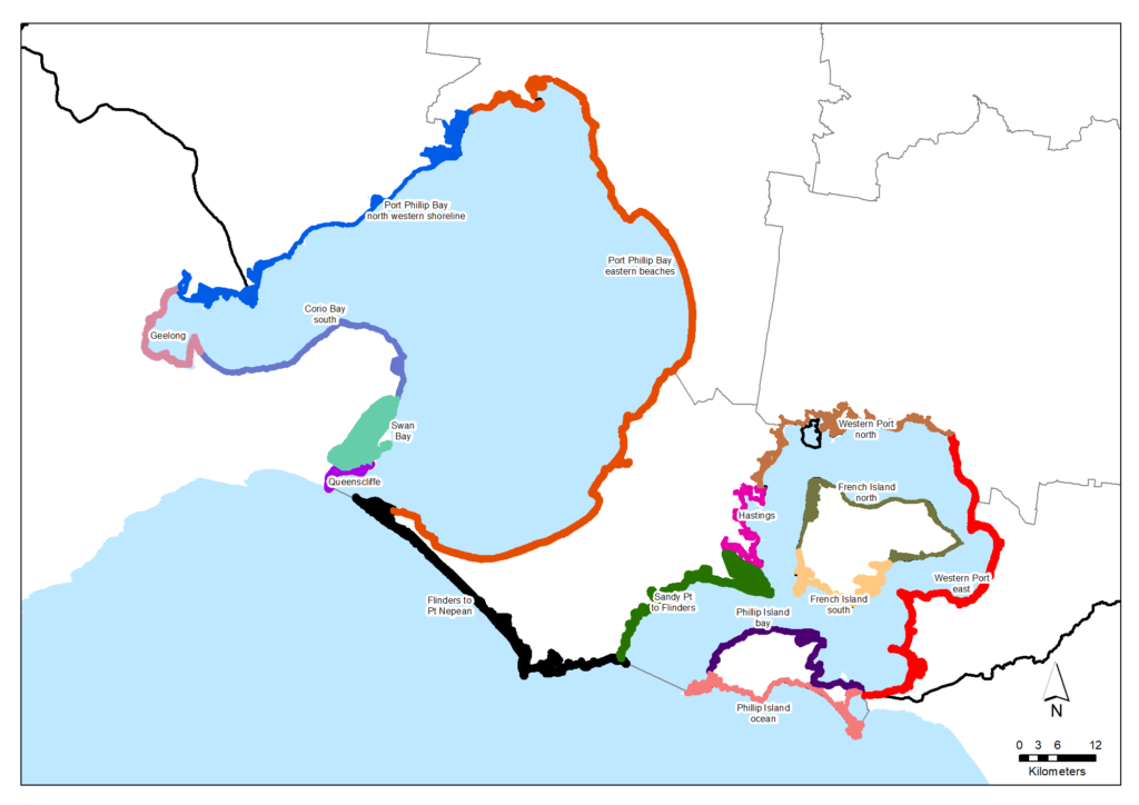
In developing this Regional Catchment Strategy, the region’s coast has been divided into 14 zones as shown in the map below. The zones are delineated by significant changes in coastal characteristics and/or environmental values and where it is sensible to attach tailored environmental targets.
(Note: In the years ahead, different zones may be used as part of the Department of Energy, Environment and Climate Action’s state-wide approach to coastal planning and management, which may align with a national classification of ‘coastal compartments’).
Coastal zones and estimated amount and proportion of native vegetation (from Victorian Land Cover Time Series)
| Coastal zone | Approximate length (km) | Approximate average width (m) | Approximate area (ha) | Area of native vegetation (ha) | Proportion of zone with native vegetation (%) |
|---|---|---|---|---|---|
| Phillip Island ocean | 42 | 260 | 1,087 | 1,009 | 93% |
| Phillip Island bay | 37 | 120 | 414 | 367 | 89% |
| French Island south | 24 | 340 | 810 | 788 | 97% |
| French Island north | 40 | 350 | 1,354 | 1,327 | 98% |
| Western Port east | 55 | 140 | 757 | 622 | 82% |
| Western Port north | 40 | 450 | 1,557 | 1,427 | 92% |
| Hastings | 23 | 460 | 842 | 734 | 87% |
| Sandy Point to Flinders | 33 | 440 | 1,310 | 1,165 | 89% |
| Flinders to Point Nepean | 46 | 450 | 2,073 | 1,901 | 92% |
| Port Phillip bay eastern beaches | 116 | 80 | 959 | 770 | 80% |
| Port Phillip bay north western shoreline | 60 | 450 | 1,707 | 1,515 | 89% |
| TOTAL | 516 | 3,540 | 12,871 | 11,624 | 90% |
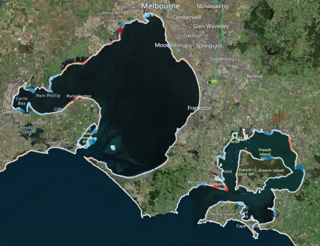
Different areas of coast in this region have grown or retreated over the past 30 years, as illustrated in the map below. The estimated changes can be viewed and explored in more detail at a Digital Earth Australia Map.
Key challenges and drivers of change
The Marine and Coastal Policy states that the health of the marine and coastal environment is under threat from multiple sources, including climate change and growth in towns, cities and industries that interact with their local marine and coastal ecosystems.
These threats can lead to negative impacts on water quality and quantity, pollution and debris, invasive species, marine pests and diseases, disturbance and loss of plants and animals, and loss of access to beaches from the effects of sea walls, infrastructure and erosion. Coastal towns can also suffer loss of character from inappropriate development and poor management of visitors’ actions and impacts. Degradation occurs over time and space, and the impacts in marine and coastal areas are varied and complex.
Population growth
Victoria has experienced record population growth over the past decade with suburbs and towns around Port Phillip Bay, and within two hours’ drive of Melbourne (including on the Bellarine Peninsula, Mornington Peninsula and Bass Coast), recording big increases in population size and density. Growth in the permanent population has also been accompanied by increases in numbers of domestic, national and international visitors to coastal areas.
Growth in resident populations and visitor numbers puts pressure on the health of the coastal environment, with direct impacts including:
- Habitat loss and degradation
- Increased introduction of invasive and pest species
- Increased pollution from sources including litter,
- Stormwater runoff and wastewater discharges
- Erosion of dunes
- Loss of character of coastal towns.
Population growth also increases pressure on recreational infrastructure such as walking tracks, visitor facilities, lifesaving clubs and recreational club houses, boat ramps and marinas. This, in turn, leads to more demand for alterations to beaches, foreshores, wetlands and natural processes through groynes, sea walls and dredging to support use and development.
Climate change
Climate change is increasing the pressure on Victoria’s marine and coastal environment by exacerbating existing threats and introducing new ones, such as:
- Rising sea levels, leading to more inundation and erosion
- Increased frequency and severity of storms and other extreme weather events
- Changes in ocean temperatures, currents and acidification
- Changes to waterway flows, levels and regimes
- Changes in the range, distribution and abundance of both introduced and native plants and animals, taking advantage of a changed climate
- Coastal squeeze, which occurs when coastal ecosystems forced inland by rising sea levels run into human-made barriers such as roads and housing.
Coastal settlements, suburbs and cities including densely populated areas around Port Phillip Bay, are increasingly exposed to more severe storms, coastal flooding and erosion. Existing and severe coastal erosion will be exacerbated by climate change on the northern Western Port coast at Lang Lang and on the Mornington Peninsula-Bass Strait coast between Flinders and Point Nepean. Recreational opportunities on the coast will also change as beaches and cliffs erode.
Native vegetation loss and decline due to coastal development
Some of the native coastal vegetation is secure on public land but population growth and development will continue to create pressure for clearing at some sites.
In addition, incremental damage to native vegetation from recreation, illegal clearing, vandalism and rubbish dumping are inevitable pressures of increasing resident and visitor populations.
Invasive plants and animals
Weed invasions compete with native vegetation and damage its ability to provide habitat. Much of the coastal zone has ongoing weed problems that are difficult to control. For example, coastal weeds such as Sea spurge invade the nesting habitats of shorebirds and seabirds.
These pressures are now well-established. Ongoing control is critical but expensive. It needs to be carefully targeted to maximise its benefits. Likely targets for control include:
- Known highly invasive and ecologically damaging weeds
- Emerging weeds, detected but not yet established
- Foxes and feral cats.
Ageing infrastructure
Our region has a vast inventory of coastal assets (sea walls, groynes, piers and jetties), particularly in its bays and estuaries, that have been constructed over the past 100 years. Many of these assets are ageing and, without regular maintenance or upgrading, will no longer be able to provide the services for which they were built.
However, much ageing coastal infrastructure has become integral to beach-nesting bird habitat, and provides feeding and roosting sites for migratory shorebirds. Habitat value assessments may be important before renewals are commenced.
Vision and targets for the future
Vision
Victoria’s Marine and Coastal Policy outlines a vision for:
A healthy, dynamic and biodiverse marine and coastal environment that is valued in its own right, and that benefits the Victorian community, now and in the future.
Target
To support the achievement of the state-wide vision, this Regional Catchment Strategy seeks for environmental values of the coasts in this region to be maintained as much as practicable.
A priority, reflected in the target below, is to at least maintain the current extent of native vegetation in each of this region’s coastal zones. Progress towards this target will be monitored primarily through updates to the Victorian Land Cover Time Series managed by the Department of Energy, Environment and Climate Action.
Target 10.1 – Coastal vegetation
Additional or alternative targets, and corresponding monitoring systems, may be introduced as part of Victoria’s new marine and coastal planning under development by the Department of Energy, Environment and Climate Action.
Partner organisations
The following organisations formally support the pursuit of the visions and targets for coasts. They have agreed to provide leadership and support to help achieve optimum results with their available resources, in ways such as:
- Fostering partnerships and sharing knowledge, experiences and information with other organisations and the community
- Seeking and securing resources for the area and undertaking work that will contribute to achieving the visions and targets
- Assisting with monitoring and reporting on the condition of the area.
Victorian Government
- Department of Energy, Environment and Climate Action (DEECA)
- Melbourne Water
- Victorian Fisheries Authority
- Trust for Nature
- Phillip Island Nature Parks
- Zoos Victoria
- Parks Victoria
- Environment Protection Authority Victoria (EPA)
- Victorian Planning Authority
- Sustainability Victoria
- Westernport Water
- Victorian Environmental Water Holder
Local Government
- Association of Bayside Municipalities
- City of Greater Geelong
- Wyndham City
- Hobsons Bay City Council
- City of Port Phillip
- Western Alliance for Greenhouse Action
- Northern Alliance for Greenhouse Action
- Bayside City Council
- Kingston City Council
- City of Casey
- Cardinia Shire Council
- Bass Coast Shire Council
- South East Councils Climate Change Alliance
- Eastern Alliance for Greenhouse Action
Traditional Owners
- Wadawurrung Traditional Owners Aboriginal Corporation
- Bunurong Land Council Aboriginal Corporation
Non Government
- The Nature Conservancy
- Conservation Volunteers Australia
- Birdlife Australia
- Marine Mammal Foundation
- The People and Parks Foundation
- Field Naturalists Club of Victoria
- Victorian National Parks Association
- Dolphin Research Institute
- Native Fish Australia (Vic)
- OzFish Unlimited
- Victoria Walks
- Western Port Seagrass Partnership
- Habitat Restoration Fund
Community
- Bass Coast Landcare Network
- Bass Valley Landcare Group
- French Island Landcare Group
- South Gippsland Landcare Network
- Loch-Nyora Landcare Group
- Mt. Lyall Landcare Group
- Poowong & District Landcare Group
- Triholm Landcare Group
- Mornington Peninsula Koala Conservation
- Phillip Island Landcare Group
- Western Port Catchment Landcare Network
- Westernport Swamp Landcare Group
- Main Creek Catchment Landcare Group
- Merricks Coolart Catchment Landcare Group
- NatureWest
- Friends of Lower Kororoit Creek Inc
- Hobsons Bay Wetlands Centre Inc.
- Port Phillip EcoCentre
- Werribee River Association
- Northern Yarra Landcare Network
- Gippsland Threatened Species Action Group
Add your organisation as a supporter and partner
If your organisation supports these directions and targets for coasts and wishes to be listed as a partner organisation, you can request to be listed as a partner organisation. Adding your organisation to this list will:
- Enable your organisation to list one or more priority projects in the Prospectus which will describe how your priority project will pursue the targets of this Regional Catchment Strategy and potentially make your organisation’s project more attractive to investors by using the strategy to highlight its relevance and value
- Demonstrate your commitment to a healthy and sustainable environment
- Demonstrate the level of community engagement and support for this work.
Priority projects to move forward
Priority projects
There are significant ongoing programs and initiatives undertaken by many organisations in this region that are vital for protecting and enhancing coasts and are priorities to continue. In addition, there are numerous project proposals that, if funded and implemented, can contribute to achieving the Regional Catchment Strategy’s visions and targets. A list of project proposals across the region and their key details can be viewed on the Prospectus section of this website.
Propose a new priority project
As part of the ongoing development and refinement of this Regional Catchment Strategy, additional priority projects may be considered for inclusion in the Prospectus.
If your organisation supports the directions and targets for coasts, and has a project it would like highlighted and supported in this Regional Catchment Strategy, please submit a Prospectus Project Proposal.

