This Port Phillip and Western Port Regional Catchment Strategy is a guide to conserving our region’s land, waters and biodiversity so they continue to sustain and enrich life, economies, health and social wellbeing for this and future generations.
Researching and compiling this region-scale Strategy was a major responsibility of the Port Phillip & Westernport Catchment Management Authority (now Melbourne Water). This fourth edition builds on 25 years of learning and experience in supporting collaborative achievement by Councils, Government agencies, public utilities, community organisations, businesses, farmers, landholders and citizens.
This Strategy recognises Traditional Owners as the voice for their Country and their rights to pursue their aspirations for its waterways, land and biodiversity.
Background and purpose of this strategy
This Regional Catchment Strategy’s overarching aim is to foster collaboration towards its vision of a healthy and resilient environment and well-managed natural resources.
To do this, the Strategy describes our region’s land, water, biodiversity, coastal and marine environments:
- Water supply, waterways, wetlands and groundwater
- Native vegetation and native animals
- Land use, soil health and agriculture
- Coasts, estuaries and marine environments
- Community connections and volunteering.
It explains why and where the values of these natural resources are persisting, declining or sustained. It illustrates how the use and condition of a natural resource can affect the others around or connected to it. It describes the pervasive challenge posed by climate change.
The Strategy recognises the long and proud history of environmental stewardship by Traditional Owners and how their knowledge and practice need to be restored to natural resource management. The Strategy also recognises greater inclusion and recognition of Traditional Owner rights going forward.
The strategy describes the current conservation policies and plans of some fifty agencies and organisations. It then uses these to express a region-scale vision and a comprehensive set of targets for the future condition of the region’s natural resources. The targets are designed to be pursued as common goals by multiple organisations working together.
The strategy then provides a Prospectus of project proposals that can contribute to achieving the Strategy’s targets and vision.
This Regional Catchment Strategy was developed in accordance with the requirements of national and state legislation and policies for biodiversity, land and water resources. In particular, it was prepared under the provisions of the Victorian Catchment and Land Protection Act 1994 in line with two of its key purposes:
- To set up a framework for the integrated management and protection of catchments
- To encourage community participation in the management of land and water resources.
The Port Phillip and Western Port region
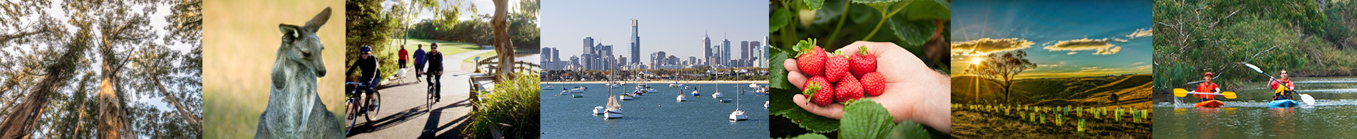
The Port Phillip and Western Port region is home to more than five million people and includes all of urban Melbourne, growth centres on the urban fringe, highly productive farming land, forested parks and ranges, and a network of rivers, wetlands and estuaries which flow to our two valuable bays – Port Phillip Bay and Western Port.
The region supports a range of non-urban land uses located on or near the urban fringe that are critical to the functioning of urban Melbourne. These include tourism, airports, water treatment plants, extractive industries, waste and resource recovery operations and renewable energy infrastructure. It is important to ensure these uses are located in areas that have as little impact as possible on biodiversity and other natural and cultural values.
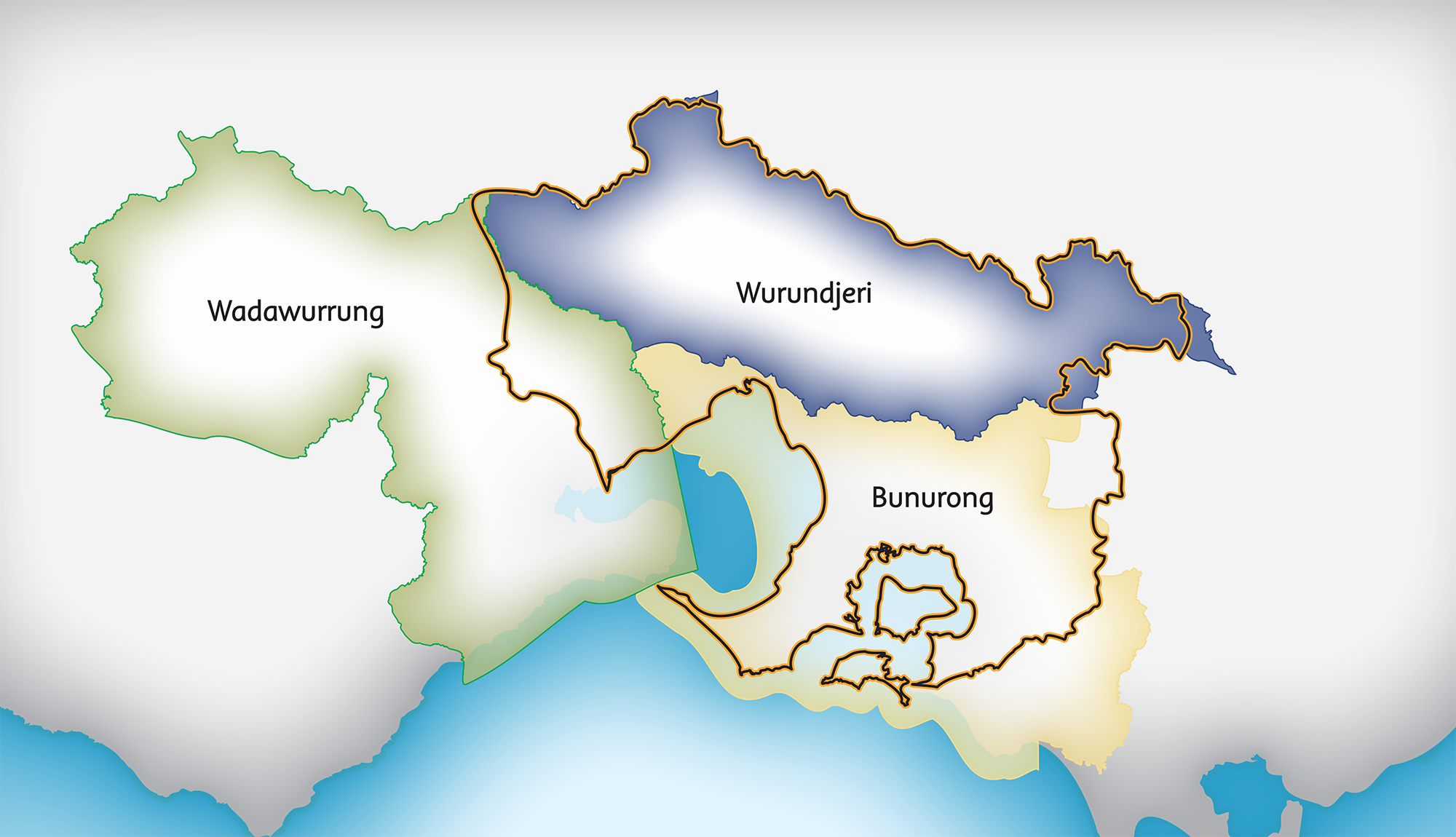
The impact of growing populations on land, waterways and the bays and the competition for space between rural, urban and coastal land uses, industry, infrastructure, recreation and conservation pose complex challenges for sustainable use of the region’s natural resources and biodiversity. The Traditional Owners of this region – the Bunurong, Wurundjeri Woi-wurrung and Wadawurrung Peoples – actively seek for the philosophy of Caring for Country to be embraced and at the centre of conservation planning and practice to restore, sustain and improve this Country.
Climate change will exacerbate these and other environmental pressures, such as drought, wildfire, weeds and pest animals on natural habitats and biodiversity. Climate change is likely to be making obsolete and perilous the trade-offs between development and conservation used in previous ‘balanced decision-making’.

Traditional Owners
This region is the Country of the Bunurong, Wurundjeri Woi-wurrung and Wadawurrung people. They have lived in and been connected to the land, water, plants and animals of this area for many thousands of years, and continue to do so.
The Bunurong, Wurundjeri Woi-wurrung and Wadawurrung people are acknowledged as the Traditional Owners of these lands and waters. They are recognised as the voice for their Country.
Read more in the Welcome to Country and the Traditional Owners and Aboriginal Victorian Theme.
Vision for the region
A healthy and resilient environment in the Port Phillip & Western Port region
In 2050, people and organisations across the Port Phillip & Western Port region will be collaborating to protect and improve the extent, quality and diversity of its environmental assets.
There will be shared leadership in planning, decision making, action, monitoring and reporting that ensures targets for all environmental assets are set and pursued to contribute to the natural ecosystems being healthy and resilient.
Read more in Vision for the Future.
Themes of this strategy
Building blocks of a healthy and resilient environment
The 15 ‘Themes’ that are the focus of this Regional Catchment Strategy are building blocks of a healthy and resilient environment for this region.
There is an analysis for each of:
- Water – Water supply and use, Waterways, Wetlands, Groundwater
- Biodiversity – Native vegetation, Native animals
- Land – Land use, Soil health, Sustainable agriculture
- Coastal and marine environments – Coasts, Estuaries, Marine environments
- Community sectors – Traditional Owners and Aboriginal Victorians, Communities
There is also a section recognising the significant and pervasive issue of Climate change.
For each theme, there is information on:
- The main policy and planning that is in place for that theme
- The current condition and trends
- Major threats and drivers of change
- The vision and targets for future condition
- Partners and supporters to help achieve the targets
- A list of some projects that can help us move forward.
Local Areas
Integration and partnerships in your local area
The following nine ‘Local Areas’ are described in this Regional Catchment Strategy with explanation of how the themes come together and interact in each place.
- Bass Coast, South Gippsland & islands
- Casey, Cardinia & Baw Baw
- Mornington Peninsula
- Yarra Ranges & Nillumbik
- Urban Melbourne
- Macedon Ranges, Hume, Mitchell & Whittlesea
- Moorabool, Melton, Wyndham & Greater Geelong
- Port Phillip Bay
- Western Port.
The purposes of describing the region in this way are to:
- Recognise the significant differences between different parts of this large region
- Break the Regional Catchment Strategy down to sub-regional level so it is more meaningful and useful for local residents and communities
- Consider how the themes of natural resource management interact in each particular area
- Enable the vision, knowledge and priorities of local organisations and communities to be highlighted
- Promote the value of organisations and communities working together at local scale.
The section on each Local Area includes:
- Overview of the community and environmental values of the area
- Current condition of the environment and significant trends
- Major challenges and drivers of change
- Vision and targets for the future
- Organisations that support the directions of this strategy
- Priority projects that can help us move forward.
Long-term targets
The following long-term targets (at the year 2050 or further) will contribute to achieving the vision for this region and help ensure this region remains healthy and prosperous for future generations. Melbourne water and its partners are committed to measuring the progress of long term targets in collaboration with the Traditional Owners of this region.
Water
1.1 Water supply and use
Adequate and stable water supplies have been secured for households, businesses, farms, Traditional Owners and the environment. Various water supply options have been effectively harnessed including stormwater harvesting, manufactured water and recycled water use. Water is shared, distributed and used efficiently by all users.
.
1.2 Water for the environment
The environmental water reserve has been increased by at least 1-5 GL/yr in the Westernport catchment, 15-25 GL/yr in the Yarra catchment and 10-20 GL/yr in each of the Maribyrnong and Werribee catchments, and an average score of HIGH has been achieved for each of those catchments.
.

1.3 Water for Traditional Owners
Support the aspirations of Wurundjeri Woi-wurrung people to pursue water justice for their people and Country by delivering water justice through water rights, participation in water management, and broader water policy and reform (as per the definition of water justice identified in the National Cultural Flows Research Project 2020).
1.4 Water for agriculture
Significant volumes of recycled water and stormwater have boosted agricultural water supply and security in the region’s irrigation districts, green wedges, peri-urban and rural areas. Major irrigation systems have been modernised to ensure efficient water delivery and use, and new irrigation networks have been established in suitable areas.

2.1 Fish in waterways
Achieve an average score for fish in waterways of at least MODERATE for the Dandenong, Maribyrnong and Werribee catchments and HIGH for the Westernport and Yarra catchments.
2.2 Waterway amenity
Achieve an average score for waterway amenity of HIGH for the Maribyrnong and Werribee catchments and VERY HIGH for the Westernport, Dandenong and Yarra catchments.
2.3 Vegetation extent along waterways
Achieve an average score for vegetation extent along waterways of at least MODERATE for the Dandenong catchment and HIGH for the Westernport, Yarra, Maribyrnong and Werribee catchments.
2.4 Vegetation quality along waterways
Achieve an average score for vegetation quality along waterways of at least MODERATE for the Westernport, Dandenong, Maribyrnong and Werribee catchments and HIGH for the Yarra catchment.

3.1 Wetlands water regime
Achieve an average score for wetlands water regime of at least LOW for the Maribyrnong and Werribee catchments, MODERATE for the Westernport and Dandenong catchments and HIGH for the Yarra catchment.
3.2 Wetlands vegetation
Achieve an average score for wetlands vegetation condition of at least MODERATE for the Dandenong, Maribyrnong and Werribee catchments and HIGH for the Westernport and Yarra catchments.
3.3 Wetlands water quality
Achieve an average score for wetlands water quality of at least LOW for the Dandenong, Maribyrnong and Werribee catchments and MODERATE for the Westernport and Yarra catchments.
3.4 Ramsar wetlands
The ecological conditions of the Western Port Ramsar wetland, Port Phillip Bay (western shoreline) Ramsar wetland and Edithvale-Seaford Ramsar wetland are maintained or improved from 2021 to 2050.

4.1 Groundwater supply and use
Groundwater licences and annual use kept within the Permissible Consumptive Volume (PCV) for each Groundwater Management Unit (GMU) in the region.
4.2 Groundwater quality
Groundwater quality in each Groundwater Management Unit (GMU) in the region maintained at sufficient standard to enable ongoing groundwater use.
Biodiversity

5.1 New parks
At least 6,500 hectares of new suburban parks established in the region by 2027. At least 15,000 hectares of a new Western Grassland Reserve and 1,200 hectares of a new Grassy Eucalypt Woodland Protected Area established in this region by 2037. Significant areas of additional new parks established across this region by 2050 providing improved security, extent and quality of native habitat.
.

5.2 Permanent protection
At least 8,250 hectares of new permanently protected vegetation areas established on private land in this region between 2017 and 2050 (an average of at least 250 hectares per year).
.

5.3 Revegetation
At least 33,000 hectares of revegetation established in priority areas for habitat connectivity in this region between 2017 and 2050 (an average of at least 1,000 hectares per year).

5.4 Major new biolinks
Significant, sustained revegetation programs have been undertaken from 2021 to 2050 and have created numerous major biolinks in priority locations across the region.

5.5 Pest and weed control
Sustained pest herbivore control maintained for at least 120,000 hectares in priority areas, and sustained weed control maintained for at least 40,000 hectares in priority areas of this region through to 2050.

5.6 Threatened vegetation
All threatened native vegetation species and ecological communities in the region are retained and are self sustainable, secure, healthy and resilient.

6.1 Diversity of native animals
Maintain the diversity of native animal species in the region from 2021 to 2050 and ensure the populations are sustainable, secure, healthy and resilient.
6.2 Threatened animals
Wild populations of all threatened native animal species in the region are retained and their populations are self-sustainable, secure, healthy and resilient.

6.3 Pest predator control
Sustained pest predator control maintained for at least 40,000 hectares in priority areas of this region through to 2050. Feral cats remain absent on French Island maintaining an island safe-haven for wildlife.
Land
7.1 Land use
While planned urban development progresses in the region, the extent and quality of native vegetation, significant landscapes, cultural heritage values and environmental assets are retained. Water supply catchments, state significant infrastructure, extractive resources, open space areas and agriculture are carefully planned for and protected. Sufficient extent and quality of native vegetation and agriculture is retained, including in the Green Wedges, to support healthy ecosystems and agricultural industries.
.
8.1 Exposed soil
The proportion of exposed soil in the region remains in the range 10% to 15%, or less, each year from 2020 to 2050.
.

9.1 Land for agriculture
The Green Wedges and high value agricultural land of this region are retained for agricultural use and are supporting diverse and profitable agricultural enterprises.

9.2 Sustainable agriculture systems
This region’s farms and agricultural industries are recognised as leaders in agri-ecological sustainability and resilience.

9.3 Agricultural production
Annual agricultural production in the region of approximately $7.6 billion (growth of 5.4% per year in line with national target), and an increasing trend in employment levels between 2019 and 2050.
Coasts and marine
10.1 Coastal vegetation
Native vegetation continues to occupy around 90% of the area of the coastal zones around the region from 2021 to 2050 and supports coastal stability and healthy coastal ecosystems.
.
11.1 Estuarine flow regime
Achieve an average score for estuarine flow regime of at least LOW for the Westernport, Dandenong and Maribyrnong catchments, MODERATE for the Werribee catchment and HIGH for the Yarra catchment.
.
11.2 Estuarine vegetation
Achieve an average score for estuarine vegetation of at least LOW for the Dandenong, Yarra and Maribyrnong catchments, MODERATE for the Werribee catchment and HIGH for the Westernport catchment.
12.1 Marine water quality
Water quality in Port Phillip Bay and Western Port continues to attain the relevant Environment Reference Standard which sustains healthy ecosystems and supports fishing and enables safe swimming at most times.
12.2 Marine parks
The 4 Marine National Parks and 4 Marine Sanctuaries in Port Phillip Bay and Western Port remain in excellent condition and protected.
12.3 Marine habitats
The extent and health of the various marine habitat types in Port Phillip Bay and Western Port is retained or improved from 2021 to 2050, including mangrove, seagrass, rocky reef and kelp forests.
12.4 Marine pests
Existing damaging marine pest infestations in Port Phillip Bay and Western Port (from 2021) are controlled or reduced at 2050, and no significant new marine pests have become established.
12.5 Fisheries
The diversity of fish species in Port Phillip Bay and Western Port is retained and their populations, including those targeted for recreational and commercial fishing, remain healthy and sustainable
Traditional Owners

13.1 Traditional Owners as the ‘voice’ for waterways and Country
Traditional Owners are the strong and respected voice for Country, with fundamental roles and influence in planning, decision making and action across the region in land, biodiversity and water management. The value of traditional ecological knowledge held by the region’s Traditional Owners is embraced and influential in modern decisions and practices.
.

13.2 Cultural heritage sites
The number of cultural heritage sites in the region that are formally registered has increased, intact sites are effectively protected and Traditional Owners are involved in the care and preservation of all key sites. More importantly, the recognition of cultural heritage has evolved to include intangible values (such as cultural practices, knowledge and oral traditions) and the continuous connection embodied in the concept of “Country”.
.

13.3 Indigenous representation in NRM
Traditional Owners are well represented in relevant organisational Boards. All major natural resource management forums and planning processes in this region include Indigenous representation.
13.4 Indigenous employment in NRM
Organisations with major roles in natural resource management in this region collectively have a level of Indigenous employment that is well above the public sector average and stable.
Communities
14.1 Landcare group health
Landcare groups across the region maintain an average group health score of at least 3.7/5.
.

14.2 Community volunteering
Community volunteering for natural resource management surpasses 1 million hours per year.
.
14.3 Community participation
Over 2 million people participate annually in natural resource management events and activities conducted by relevant agencies, Councils and community groups across the region.
Climate change
15.1 Carbon emissions
Victoria has achieved net zero emissions. From the natural resource management sector, all water corporations have achieved net zero emissions. The agriculture sector has contributed to the achievement of this economy-wide net zero emissions target.
.

12.2 Cooling, greening Melbourne
Total tree canopy and shrub cover for metropolitan Melbourne areas has increased to at least:
– Western 30%
– Northern 39%
– Inner 33%
– Southern 50%
– Inner South-East 50%
– Eastern 50%.
.

15.3 Climate change adaption
Government, organisations, communities and individuals have responded effectively to the challenges of climate change, minimising the negative impacts on ecological, social and economic well-being.
Implementation

16.1 Partner organisations
Organisations and people across the region are partnering to protect and improve the environment and natural resources. There is shared leadership and coordination in planning, decision making, action, monitoring and reporting.
.

16.2 Regional investment in natural resource management
The collective investment in natural resource management in the region by key organisations is regularly estimated, has had sustained growth over time, and benefits are being achieved through shared investment, partnerships and increased efficiency.
.

16.3 Strengthened links with the planning system
Catchment Strategy and the planning system have been established and are generating strong coordination and alignment strategic and statutory in planning and decision making.

16.4 Reporting
Systematic and comprehensive links between the Regional Regular, comprehensive reporting on the condition of the region’s natural resources has been undertaken and has influenced the scope and scale of programs to ensure the region’s natural resources are protected and retained in suitable condition.
Partner Organisations
The organisations listed in the table below have formally agreed to be ‘Partner Organisations’ in this Regional Catchment Strategy for Themes and Local Areas that are relevant to them. They have agreed to provide leadership and support to help achieve optimum results with their available resources, in ways such as:
- Fostering partnerships and sharing knowledge, experiences and information with other organisations and the community
- Seeking and securing resources for the area and undertaking work that will contribute to achieving the visions and targets
- Assisting with monitoring and reporting on the condition of the area.
The number and diversity of Partner Organisations strongly signals that there are many enthusiastic and willing supporters for natural resource and environmental management programs in this region.
Victorian Government
- Melbourne Water
- Department of Energy, Environment and Climate Action (DEECA)
- Parks Victoria
- Environment Protection Authority Victoria (EPA)
- Victorian Planning Authority
- Victorian Fisheries Authority
- Trust for Nature
- Sustainability Victoria
- Zoos Victoria
- Agriculture Victoria – Department of Energy, Environment and Climate Action
- Greater Western Water
- Yarra Valley Water
- South East Water
- South Gippsland Water
- Westernport Water
- Southern Rural Water
- Phillip Island Nature Parks
- Victorian Environmental Water Holder
Local Government
- Hume City Council
- City of Whittlesea
- Brimbank City Council
- Moonee Valley City Council
- Wyndham City
- Moorabool Shire Council
- Hobsons Bay City Council
- Macedon Ranges Shire Council
- Manningham City Council
- City of Melbourne
- Monash City Council
- Kingston City Council
- City of Stonnington
- City of Port Phillip
- City of Casey
- Cardinia Shire Council
- Baw Baw Shire Council
- City of Greater Geelong
- Maroondah City Council
- Bayside City Council
- Glen Eira City Council
- City of Greater Dandenong
- Whitehorse City Council
- Knox City Council
- South Gippsland Shire Council
- Bass Coast Shire Council
- Association of Bayside Municipalities
- Eastern Region Pest Animal Network
- Western Alliance for Greenhouse Action
- Northern Alliance for Greenhouse Action
- South East Councils Climate Change Alliance
- Eastern Alliance for Greenhouse Action
Traditional Owners
- Wadawurrung Traditional Owners Aboriginal Corporation
- Wurundjeri Woi-wurrung Cultural Heritage Aboriginal Corporation
- Bunurong Land Council Aboriginal Corporation
Non Government
- The Nature Conservancy
- Conservation Volunteers Australia
- Gardens for Wildlife Victoria
- Native Fish Australia (Vic)
- Victoria Walks
- Field Naturalists Club of Victoria
- GippsDairy
- Western Port Seagrass Partnership
- Mornington Peninsula and Western Port Biosphere Reserve Foundation
- Victorian National Parks Association
- OzFish Unlimited
- Mt Rothwell Biodiversity Centre / Odonata
- Marine Mammal Foundation
- Dolphin Research Institute
- Birdlife Australia
- The People and Parks Foundation
- Habitat Restoration Fund
Community
- Middle Yarra Landcare Network
- Port Phillip EcoCentre
- Hobsons Bay Wetlands Centre Inc.
- Werribee River Association
- Friends of Lower Kororoit Creek Inc
- Federation for Environment and Horticulture in the Macedon Ranges
- Upper Deep Creek Landcare Network
- Jacksons Creek EcoNetwork
- Greening of Riddell
- Friends of Emu Bottom Wetlands Reserve
- Friends of Daly Nature Reserve
- Deep Creek Landcare Group
- Riddells Creek Landcare Group
- Newham and District Landcare Group
- Merri Creek Management Committee
- Darebin Creek Management Committee
- NatureWest
- Little River Community Landcare Inc
- Yarra Riverkeeper Association
- Yarra Ranges Landcare Network
- Northern Yarra Landcare Network
- Nillumbik Landcare Network
- Nangana Landcare Network
- Johns Hill Landcare Group
- Gippsland Threatened Species Action Group
- Bass Coast Landcare Network
- Bass Valley Landcare Group
- French Island Landcare Group
- South Gippsland Landcare Network
- Loch-Nyora Landcare Group
- Mt. Lyall Landcare Group
- Poowong & District Landcare Group
- Triholm Landcare Group
- Kooyongkoot Alliance
- Friends of Olinda Creek
- Abbotsford Riverbankers Inc
- Rewilding Stonnington
- Friends of Dandenong Valley Parklands
- Southern Ranges Environment Alliance
- Cardinia Environment Coalition
- Mornington Peninsula Landcare Network
- Main Creek Catchment Landcare Group
- Merricks Coolart Catchment Landcare Group
- Manton & Stony Creeks Landcare Group
- Sheepwash Creek Catchment Landcare Group
- Red Hill South Landcare Group
- Phillip Island Landcare Group
- Western Port Catchment Landcare Network
- Westernport Swamp Landcare Group
- Mornington Peninsula Koala Conservation
Prospectus
A Prospectus accompanies this Regional Catchment Strategy. The Prospectus is akin to a ‘stakeholder billboard’ on which organisations summarise their most important, desirable, practical and/or innovative project proposals that can individually and collectively contribute to achieving the strategy’s targets. It is a starting point from which:
- Stakeholders can build a case for funding from within their own organisations (eg. within annual Council budgeting processes) by showing that the project is aligning with regional, state and/or national priorities
- Stakeholders can identify similar or complementary project ideas listed by other organisations and then make a connection and potentially expand or merge their proposals
- Potential investors from the public, private or philanthropy sectors can efficiently browse project ideas across the region (and the connection of each to themes, areas, investment priorities) and identify those they wish to pursue by following up with the project proponent and partners
- Melbourne Water (as the Regional Catchment Strategy coordinator) and/or others can sort the list when a new funding opportunity emerges and create a ‘short list’ of ideas that meet the funding criteria and can be further developed and promoted.