The land on which we live
The Port Phillip and Western Port region covers around 1.28 million hectares, or 5.6 per cent of Victoria.
The urban area currently covers around 172,000 hectares or 14 per cent of the region. It contains over 5 million residents as well as the infrastructure, open space and natural areas that they need.
Around 44 per cent of the region is used for agriculture. A further 42 per cent is under native vegetation on private land and on public land in reserves, parks and water supply catchments. Much of the region’s food, water, timber, building stone and sand supplies come from its rural areas. Protecting these primary industries and habitat for native species, natural areas and scenic landscapes is an important aim for the region’s green wedges and surrounding rural land.
Around 44 per cent of the region is currently used for agriculture and green wedges and around 42 per cent is native vegetation including the large parks and water supply catchments. Much of the region’s natural resource production comes from the rural and vegetation areas, including food, water, timber and minerals. Rural areas also provide habitat for native species, recreational sites, protected natural areas and scenic landscapes.
The rural and urban land in the region includes around 300,000 hectares of public land – a network of eight national parks, six state parks and numerous regional, metropolitan and local parks, conservation reserves and coastal reserves, historic and cultural sites, road reserves and waterways. The parks include the closed catchments that supply Melbourne’s water. Other areas supply timber and other forestry products. Social and environmental benefits of public land and open space include opportunities for recreation, tourism, nature conservation and protection of biodiversity, culture and heritage.
By 2030, the population is forecast to grow by a further one million people which will place pressure on rural land outside the Urban Growth Boundary for conversion to urban use. The proximity of green wedge and peri-urban land to Melbourne makes the range of land uses competing for space some of the most contested in the state.
Land use across the region
Agriculture, vegetation, urban
The map and table below provide an estimation of the broad land use across the region – categorised as agriculture, native vegetation or urban. The information is drawn from the Victorian Land Cover Time Series data developed by the former Department of Environment, Land, Water and Planning (now Department of Energy, Environment and Climate Action) for the period 2015-19.
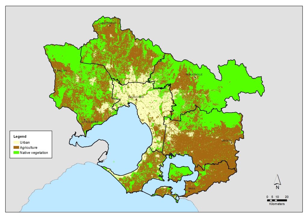
Land use by Local Area (derived from Victorian Land Cover Time Series data)
| Bass Coast, South Gippsland & islands | Casey, Cardinia & Baw Baw | Mornington Peninsula | Yarra Ranges & Nillumbik | Urban Melbourne | Macedon Ranges, Hume, Mitchell & Whittlesea | Melton, Moorabool, Wyndham & Greater Geelong | Total | |
|---|---|---|---|---|---|---|---|---|
| Local Area (Hectares) | 84,919 | 237,926 | 72,004 | 264,786 | 145,391 | 221,779 | 251,541 | 1,278,346 |
| Urban | 2,073 (2%) | 16,345 (7%) | 12,491 (17%) | 9,669 (4%) | 99,882 (69%) | 17,768 (8%) | 14,173 (6%) | 172,400 (14%) |
| Agriculture | 60,441 (71%) | 155,610 (65%) | 38,864 (54%) | 62,140 (23%) | 23,223 (16%) | 120,005 (54%) | 103,851 (41%) | 564,134 (44%) |
| Native vegetation | 22,405 (26%) | 65,971 (28%) | 20,650 (29%) | 192,976 (73%) | 22,287 (15%) | 84,006 (38%) | 133,517 (53%) | 541,812 (42%) |
Green wedges
As Melbourne grows, planning for green wedges and peri-urban areas is particularly important to:
- protect areas important for biodiversity including national and state parks, Ramsar wetlands and coastal areas
- support existing and potential agribusiness activities, forestry, food production and tourism
- protect major state infrastructure and resource assets including water supply dams, catchments and waste management and recycling facilities
- support renewable energy sources such as wind and solar farms
- ensure extractive industries can provide for the region’s building stone and sand needs with minimum impact on local amenity
- provide recreational resources which contribute to public health outcomes for all Victorians.
Key challenges and drivers of change
Changing land use
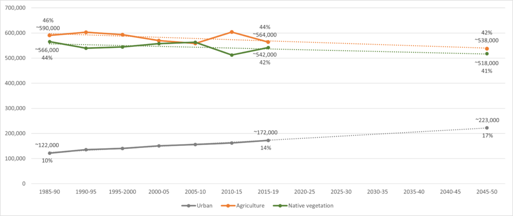
Over the past decade, Melbourne has added more than 800,000 new residents and by 2051, the population will have grown from 4.5 million today to almost 8 million.
To remain liveable our region must avoid the temptation to sprawl as it grows. Melbourne’s green wedges and peri-urban areas must be properly managed so that valued features and attributes are protected. A balance must be maintained between the needs of the community, the economy and the environment.
| Land use | 1985-1990 | 2015-2019 |
|---|---|---|
| Agriculture | ~590,677 ha. (46%) | ~564,134 ha. (44%) |
| Native vegetation | ~565,745 ha. (44%) | ~541,812 ha. (42%) |
| Urban | ~121,923 ha. (10%) | ~172,399 ha. (14%) |
Melbourne’s green wedges and peri-urban areas are immensely important to the state’s economy, community and environment and support a wide range of non-urban land uses and activities. Some of Victoria’s most productive agricultural land is located within these areas. Other productive non-urban land uses include natural resource extraction, tourism, airports, water treatment plants and waste and resource recovery operations.
These areas also accommodate businesses that need buffers from residential and incompatible land uses. Non-urban land uses in the green wedges and peri-urban areas should be carefully planned and managed to avoid irreversible land-use change and support their ongoing productivity. Agricultural land in green wedges and peri-urban areas should be retained for productive use so it is not permanently lost.
The area of the 19 individual land use types over the past 30 years, including for each of the Local areas, can be viewed at the Land use data page.
Climate change
Climate change has resulted from decades of unsustainable human activity. As most people now live in urban centres, cities and urban activities are the greatest contributors to climate change.
If rapid urbanisation of our region continues, the effects of urban heat islands, decreasing tree canopy cover and reducing water resources will be felt by many. the threat and impacts of sea level rise, with an extensive coastline and areas of low-lying land.
Access to resources such as water, land and energy will affect how and where businesses and people locate and operate.
As we experience more frequent storm and flash flooding events coupled with sea level rises, more land and properties along rivers and in coastal areas in our region will be impacted.
Protecting Melbourne’s biodiversity and natural assets is essential for remaining a productive and healthy city.
Economic growth
To grow jobs and create accessible, affordable and attractive neighbourhoods, Melbourne needs to take advantage of the land it has available for renewal in the city and suburbs. Increasing the number and diversity of jobs closer to where people live – in places such as suburban employment clusters, health and education precincts and industrial precincts – will help make Melbourne more productive and competitive.
Transport
Although the city’s transport system has sound foundations, it is coming under increased pressure from growth. By 2050, Melbourne’s transport network will need to handle up to an extra 10 million trips per day. Congestion and overcrowding is already an issue on parts of the road and public transport network, particularly at peak times. Ongoing investment in transport infrastructure will boost rail and road capacity to meet the transport challenge, boost productivity, conserve energy, curb greenhouse gas emissions and protect liveability.
Policy and planning
Plan Melbourne 2017-2050 is the metropolitan planning strategy to manage Melbourne’s growth and change over the next three decades. As part of its implementation, Land Use Framework Plans are being developed to guide strategic land-use and infrastructure development for the next 30 years for the following six metropolitan Melbourne regions:
- Inner (Melbourne, Port Phillip and Yarra Local Government Areas)
- Inner South East (Bayside, Boroondara, Glen Eira and Stonnington)
- Eastern (Knox, Manningham, Maroondah, Monash, Whitehorse and Yarra Ranges)
- Southern (Cardinia, Casey, Frankston, Greater Dandenong, Kingston and Mornington Peninsula)
- Western (Brimbank, Hobsons Bay, Maribyrnong, Melton, Moonee Valley and Wyndham)
- Northern (Banyule, Darebin, Hume, Mitchell, Moreland, Nillumbik and Whittlesea).
The Victorian Planning Authority manages the development of Precinct Structure Plans (PSPs) for Melbourne’s urban growth areas, which are master plans for local areas that usually cater for between 5,000 to 30,000 people, 2,000 to 10,000 jobs or a combination of both. PSPs provide more specific detail regarding how existing important features of local communities such as roads, shopping centres, schools, parks, key transport connections and areas for housing and employment may evolve or transform over time and become better integrated.
The Victorian Government has also developed Open Space for Everyone as a blueprint for planning and managing Melbourne’s open space network. It aims to foster coordinated decision-making and action by governments, Traditional Owners, communities, researchers and business to protect existing open space and use a wide variety of public lands for new parks and trails.
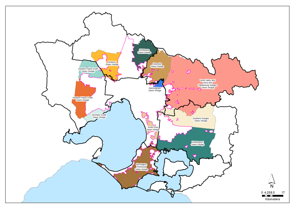
Planning for Melbourne’s green wedges and agricultural land is underway by the Victorian Government to ensure these areas are protected and supported for future generations. The Government’s intention to permanently protect Melbourne’s green wedges and vital agricultural land from inappropriate use and development remains strong and community consultation has been undertaken to determine priority ways to achieve this. Implementation of planning reforms is expected to commence in the second half of 2021.
The Catchment and Land Protection Act 1994 provides for the management of extractive industries within catchments, including revegetation of quarries and mines after they have ceased operation. The Helping Victoria Grow: Extractive Resources Strategy outlines the Victorian Government’s approach to secure and manage reliable future supplies of sand, clay, rock and gravel for building and road construction.
Traditional Owners are the voice of their Country
For all policy and planning, there is a need for recognition and inclusion of Traditional Owner knowledge and aspirations (see target 13.1). The water and lands are increasingly being recognised as ‘living and integrated natural entities‘ and the Traditional Owners should be recognised as the ‘voice of these living entities’. Country Plans will describe the vision and priorities of the Traditional Owners for Country in line with their roles as Registered Aboriginal Parties, and will provide a strong basis for all planning to recognise and include the voice of these Traditional Owners.Vision and targets for the future
Vision
Plan Melbourne 2017-2050 has a broad vision that “Melbourne will continue to be a global city of opportunity and choice” and includes policies and directions to:
- Protect agricultural land and support agricultural production in Melbourne’s green wedges and peri-urban areas, which is vital to Melbourne’s long-term food security while also providing green buffers for urban areas. This land should be retained for productive use so it is not permanently lost.
- Define and protect areas within Melbourne’s green wedges and peri-urban areas that are strategically important to Urban Melbourne and the state.
- Protect and restore natural habitats, noting that there is a critical need to maintain and improve the overall extent and condition of natural habitats.
- Identify and protect extractive resources (such as stone and sand) which are important for Melbourne’s future needs, without impacting on local amenity.
The Open Space for Everyone Strategy has a vision that:
Melbourne is a city in nature with a flourishing and valued network of public open space that is shared and accessible by everyone.
Targets
Contributing to these visions, a broad target for this region regarding land use is:
Target 7.1 – Land use
Partner organisations
The following organisations formally support the pursuit of the visions and targets for land use. They have agreed to provide leadership and support to help achieve optimum results with their available resources, in ways such as:
- Fostering partnerships and sharing knowledge, experiences and information with other organisations and the community
- Seeking and securing resources for the area and undertaking work that will contribute to achieving the visions and targets
- Assisting with monitoring and reporting on the condition of the area.
Victorian Government
- Department of Energy, Environment and Climate Action (DEECA)
- Melbourne Water
- Victorian Planning Authority
- Sustainability Victoria
- Agriculture Victoria -Department of Energy, Environment and Climate Action
- Environment Protection Authority Victoria (EPA)
- Trust for Nature
- Westernport Water
Local Government
- Hume City Council
- City of Whittlesea
- Macedon Ranges Shire Council
- City of Greater Geelong
- City of Melbourne
- Monash City Council
- Bayside City Council
- Kingston City Council
- Knox City Council
- Maroondah City Council
- City of Casey
- Cardinia Shire Council
- Baw Baw Shire Council
- Bass Coast Shire Council
- South East Councils Climate Change Alliance
- Wyndham City
- Moorabool Shire Council
- Hobsons Bay City Council
- Brimbank City Council
- Moonee Valley City Council
- City of Greater Dandenong
- Glen Eira City Council
- City of Stonnington
- Whitehorse City Council
- South Gippsland Shire Council
- Eastern Region Pest Animal Network
- Western Alliance for Greenhouse Action
- Northern Alliance for Greenhouse Action
- Eastern Alliance for Greenhouse Action
Traditional Owners
- Wadawurrung Traditional Owners Aboriginal Corporation
- Bunurong Land Council Aboriginal Corporation
Non Government
- The Nature Conservancy
- Conservation Volunteers Australia
- Mt Rothwell Biodiversity Centre / Odonata
- Gardens for Wildlife Victoria
- Habitat Restoration Fund
- Victorian National Parks Association
- Victoria Walks
- GippsDairy
- Birdlife Australia
- The People and Parks Foundation
Community
- NatureWest
- Jacksons Creek EcoNetwork
- Friends of Emu Bottom Wetlands Reserve
- Friends of Daly Nature Reserve
- Deep Creek Landcare Group
- Riddells Creek Landcare Group
- Newham and District Landcare Group
- Upper Deep Creek Landcare Network
- Merri Creek Management Committee
- Darebin Creek Management Committee
- Werribee River Association
- Little River Community Landcare Inc
- Friends of Lower Kororoit Creek Inc
- Port Phillip EcoCentre
- Federation for Environment and Horticulture in the Macedon Ranges
- Middle Yarra Landcare Network
- Yarra Ranges Landcare Network
- Northern Yarra Landcare Network
- Nillumbik Landcare Network
- Gippsland Threatened Species Action Group
- Nangana Landcare Network
- Johns Hill Landcare Group
- Cardinia Environment Coalition
- Bass Coast Landcare Network
- Bass Valley Landcare Group
- French Island Landcare Group
- South Gippsland Landcare Network
- Loch-Nyora Landcare Group
- Mt. Lyall Landcare Group
- Poowong & District Landcare Group
- Triholm Landcare Group
- Kooyongkoot Alliance
- Main Creek Catchment Landcare Group
- Sheepwash Creek Catchment Landcare Group
- Manton and Stony Creeks Landcare Group
- Merricks Coolart Catchment Landcare Group
- Red Hill South Landcare Group
- Mornington Peninsula Koala Conservation
- Phillip Island Landcare Group
- Western Port Catchment Landcare Network
- Westernport Swamp Landcare Group
Add your organisation as a supporter and partner
If your organisation supports these directions and targets for land use and wishes to be listed as a partner organisation, you can request to be listed as a partner organisation. Adding your organisation to this list will:
- Enable your organisation to list one or more priority projects in the Prospectus which will describe how your priority project will pursue the targets of this Regional Catchment Strategy and potentially make your organisation’s project more attractive to investors by using the strategy to highlight its relevance and value
- Demonstrate your commitment to a healthy and sustainable environment
- Demonstrate the level of community engagement and support for this work.
Priority projects to move forward
Priority projects
There are significant ongoing planning processes, programs and initiatives involving many organisations in this region that are vital for the management of land use and are priorities to continue. In addition, there are numerous project proposals that, if funded and implemented, can contribute to achieving the Regional Catchment Strategy’s visions and targets. Project proposals include:
- I ❤ the Mornington Peninsula proposed by Melbourne Water
- Land regeneration proposed by the Mornington Peninsula Shire Council.
A list of project proposals across the region and their key details can be viewed on the Prospectus page of this Regional Catchment Strategy.
Propose a new priority project
As part of the ongoing development and refinement of this Regional Catchment Strategy, additional priority projects may be considered for inclusion in the Prospectus.
If your organisation supports the directions and targets for land use, and has a project it would like highlighted and supported in this Regional Catchment Strategy, submit a Prospectus Project Proposal.


