A hidden resource
Groundwater is water that is found below the surface of the ground. It may be out of sight, but it is a highly valuable resource which supports various economic, environmental, cultural and social needs of our region and community.
Groundwater mainly comes from rainfall and is stored in aquifers (layers of fractured rock, gravel, sand or limestone below the ground surface) when the water seeps from the ground surface down to the water table directly or from rivers, lakes and wetlands. The slow discharge of groundwater from aquifers to some rivers, lakes and wetlands is a critical part of their continuous supply of water.
How much groundwater we can sustainably use from an aquifer depends on keeping an equilibrium between the rates of recharge (water flowing into the aquifer) and discharge (water flowing out of, or being extracted from, the aquifer). If we take out groundwater more quickly than it is recharged, groundwater levels and quality can decline. If this continues for long enough, it can have negative impacts on the groundwater reserve, the water users and the local environment.
This section of the Regional Catchment Strategy summarises the state of the groundwater resources in the Port Phillip and Western Port region. It draws mainly on information provided by the authorities responsible for managing and sustaining the groundwater resources in this region.
Policy and planning
A growing demand for groundwater combined with periods of low rainfall has led to increased regulation and management of groundwater resources.
State level
The Department of Energy, Environment and Climate Action (DEECA) is the authority responsible for State policy, resource appraisals and the State Observation Bore Network. DEECA has led the development of:
- Water for Victoria which establishes the state-wide policy framework for groundwater management
- The Central Region Sustainable Water Strategy which aims to secure water supplies, encourage economically viable and sustainable agriculture and protect the health of the environment (with this strategy being updated in 2021-22)
- the Water Register which stores and reports water entitlement information
- a framework of groundwater management boundaries.
The framework of groundwater management boundaries enables the identification of Groundwater Management Units (GMUs) – areas of groundwater with significant use/value or that are subject to particular risks. Each GMU has a cap on the amount of groundwater that can be extracted from it, called a Permissible Consumptive Volume (PCV). The PCV establishes the upper limit of entitlements for that GMU.
Groundwater licensing and management in the Port Phillip & Western Port region, and indeed across all of southern Victoria, is led by Southern Rural Water.
Complementing the groundwater policy and management arrangements, the Environment Protection Authority manages a set of State environment protection policies (SEPPs) that apply across Victoria. The SEPP (Waters) provides for the protection and management of surface water and groundwater in Victoria by establishing in law the uses and environmental values to be protected, defining the level of environmental quality required for their protection, and setting rules and obligations to ensure management actions are taken to protect water quality.
Regional and local level
Southern Rural Water has produced the Port Phillip and Western Port Groundwater Atlas providing an overview of the location, use, condition and management issues for groundwater resources in this region, and has in place the following local management plans and groundwater catchment statements for the GMUs in this region:
Southern Rural Water also produces Local water reports that include recent information on metered groundwater extraction, groundwater trends and emerging local groundwater issues.
Groundwater in this region today
Aquifer groups
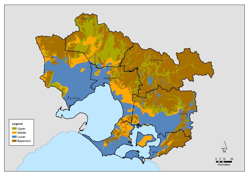
The Port Phillip and Western Port Groundwater Atlas outlines a simple grouping of aquifers according to when they were formed and the depth that they generally occur.
The basement and lower aquifers were formed earliest and the middle and upper aquifers were formed later.
| Aquifer group | Geological age |
|---|---|
| Upper | 0.01 - 4 million years |
| Middle | 4 - 38 million years |
| Lower | 19 - 65 million years |
| Basement | 65 - 545 million years |
Groundwater users
The atlas also identifies four groups of groundwater users based on what they use groundwater for and the type of aquifer they are most likely to access.
| User group | Description of user group | Type of aquifer accessed |
|---|---|---|
| Domestic and stock (D&S) | All private rights D&S users in the region: rural users and private urban users (garden watering). Many users who generally extract quite small volumes. Public emergency water supply use. | Mostly upper and middle aquifers |
| Environment | Springs, streams, lakes, swamps, wetlands and plants (which all contribute to the environmental value of the region). Total use across the region is thought to be large but cannot be quantified. | Mostly upper aquifers, outcropping areas of lower aquifers or exposed basement |
| Agribusiness | More intensive commercial, agricultural and horticultural purposes (including irrigating vegetables or pasture, dairy wash, water bottling and aquaculture). Occurs mainly in the areas south-east of Melbourne and in smaller pockets around Bacchus Marsh, Lancefield, Werribee and Wandin. A smaller number of users than the D&S user group who generally extract larger volumes. | All aquifers |
| Urban and Industrial | Some town supplies (the groundwater is treated when used for this purpose) for residential and other purposes. Industrial uses such as equipment cooling and Managed Aquifer Recharge (MAR). A small number of users who generally extract large volumes. | Mostly middle and lower aquifers |
Groundwater Management Units
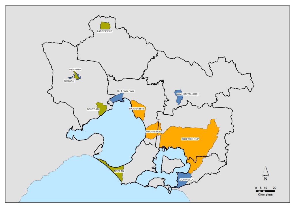
Groundwater use is concentrated in 11 areas in the Port Phillip and Western Port region, 10 of which are identified as Groundwater Management Units (GMUs). The locations and key information regarding each of these areas is outlined in the map and table below.
For most GMUs, the annual metered use of groundwater is well below the permissible volume. This indicates that, although there are limited opportunities for new entitlements, there is significant potential for trading of groundwater entitlements between users in that area. Overall within the region in 2018-19, approximately 70% of licensed entitlement was unused.
In addition to the licensing and metered use of groundwater, it should be noted that the occupant of a property has a right to extract groundwater for domestic and stock (D&S) purposes including household use, watering pets and livestock, watering a kitchen garden and watering a limited area around buildings for fire prevention.
While there are a high number of D&S users, they generally access small volumes. Southern Rural Water’s Groundwater Atlas estimated there were approximately 8,500 D&S bores registered in the region since 1980 using an average of 1.3 ML/year in rural areas and 0.2 ML/year in urban areas. This amounts to a total estimated D&S use across the region of approximately 6,500 ML/yr
| GMUs | PCV (ML) | Number of licences at 2018-19 (#) | Licenced volume at 2018-19 (ML) | Metered use in 2018-19 (ML) | Main uses | Estimated annual production value (from 2014) | Issues and restrictions |
|---|---|---|---|---|---|---|---|
| Deutgam | 5,100 | 145 | 4,981 | 796 | Mostly irrigation, some industrial and commercial | $2.3 million | Risk of salt water intrusion into aquifer from Port Phillip Bay and Werribee River if over extraction occurs. Monitoring bores are in place. No new entitlements are granted. Existing allocations can be adjusted if triggers are reached and a ban can be put in place if needed. |
| Lancefield | 1,485 | 14 | 1,378 | 282 | Irrigation. One licence for urban use. | $0.7 million | Rights can be temporarily qualified if needed |
| Merrimu | 451 | 2 | 10 | 0 | Domestic & stock | $0.5 million | Rights can be temporarily qualified if needed |
| Nepean | 6,110 | 74 | 6,104 | 2,856 | Mostly irrigation, some industrial and commercial | $12.6 million | Rights can be temporarily qualified if needed |
| Frankston | 3,200 | 28 | 2,212 | 183 | Irrigation, industrial and commercial | $0.8 million | Rights can be temporarily qualified if needed |
| Koo Wee Rup | 12,915 | 340 | 12,575 | 3,964 | Mostly irrigation, some dairying, industrial, commercial and urban | $14.8 million | Risk of salt water intrusion into aquifer from Western Port if over extraction occurs. Groundwater Management Plan is in place. Monitoring of groundwater levels occurs. Rights can be temporarily qualified if needed. Regular reviews of metered use occur. |
| Moorabbin | 2,700 | 53 | 2,604 | 1,228 | Irrigation, industrial and commercial | $3.6 million | Rights can be temporarily qualified if needed |
| Corinella | 2,550 | 12 | 661 | 63 | Urban and irrigation | $0.5 million | Rights can be temporarily qualified if needed |
| Cut Paw Paw | 3,650 | 3 | 511 | 0 | Irrigation, industrial and commercial | $0.3 million | Rights can be temporarily qualified if needed |
| Parwan | No PCV | 24 | 1,822 | 918 | Irrigation | $0.1 million | Rights can be temporarily qualified if needed |
| Wandin Yallock | 3,008 | 189 | 2,948 | 728 | Mostly irrigation, some industrial and commercial | $1.8 million | Rights can be temporarily qualified if needed |
| Outside GMUs | No PCV | 591 | 24,279 | 3,761 | Domestic & stock | $11.4 million | Rights can be temporarily qualified if needed |
| TOTAL | 1,475 | 60,085 | 14,779 | $49.4 million |
The atlas estimated in 2014 that groundwater use in this region was valued at around $50 million per year. The current value is likely to be higher than that estimate.
Groundwater dependent ecosystems
The sustainability of groundwater is also important as it provides a significant role to support groundwater dependent ecosystems (GDEs). This includes providing baseflows to rivers during summer months, supporting wetlands and providing deep pools that act as drought refuges during drier times.
Further information can be explored at the Bureau of Meteorology Groundwater Dependent Ecosystems Atlas and the Visualising Victoria’s Groundwater site.
Key challenges
Groundwater pollution
Groundwater quality can be impacted by localised (point) pollution sources or regional (diffuse) pollution sources. Unconfined aquifers close to the surface are more susceptible to pollution than deep confined aquifers. Pollution may come from various sources including industrial and intensive agricultural sites, hazardous materials or waste storage areas and septic tanks.
Seawater/saline intrusion
Sea water or saline intrusion can occur in shallow aquifers connected to the ocean or other saline water bodies such as lakes. When too much freshwater is pumped out of an aquifer the water table drops. This decreases the pressure of fresh water against the sea water or saline water and allows it to move inland.
Climate change
Changes in climate can impact groundwater levels in two ways – lower rainfall results in less recharge and higher temperatures increase the rate of evapotranspiration. On average, approximately 10% of rainfall becomes recharge to groundwater. This means that during periods of low rainfall or drought groundwater levels can decline, especially in areas where water is extracted for use.
Increasing domestic & stock use
Around 22,000 D&S bores have been registered in Southern Victoria since 1980. During the late 1960s, early 1980s and mid 2000s there was a spike in the number of D&S bores being drilled. This suggests that groundwater is seen as a backup supply in periods of drought. Groundwater bores have become increasingly popular in Melbourne’s eastern suburbs as an unrestricted, fit for purpose alternative to reticulated water.
Urbanisation
Urbanisation has the potential to impact on groundwater recharge by reducing the amount of natural permeable surfaces such as grasslands and increasing non-permeable surfaces such as concrete and other paved surfaces. This can in turn result in reduced discharge to groundwater dependent ecosystems such as rivers and wetlands. In densely populated urban areas there is also a higher risk of pollution.
Targets for the future
The following targets are proposed to achieve long-term sustainability and maintain the value of the groundwater resources in this region.
Progress toward this target will be monitored primarily using information developed and published by Southern Rural Water.
Target 4.1 – Groundwater supply and use
Target 4.2 – Groundwater quality
Partner organisations
The following organisations formally support the pursuit of the Regional Catchment Strategy’s visions and targets for groundwater. They have agreed to provide leadership and support to help achieve optimum results with their available resources, in ways such as:
- Fostering partnerships and sharing knowledge, experiences and information with other organisations and the community
- Seeking and securing resources for the area and undertaking work that will contribute to achieving the visions and targets
- Assisting with monitoring and reporting on the condition of the area.
Victorian Government
- Department of Energy, Environment and Climate Action (DEECA)
- Southern Rural Water
- Environment Protection Authority Victoria (EPA)
- Sustainability Victoria
- Victorian Environmental Water Holder
- Melbourne Water
- Yarra Valley Water
- South East Water
- South Gippsland Water
- Westernport Water
Local Government
- Hume City Council
- City of Whittlesea
- Macedon Ranges Shire Council
- Wyndham City
- Moorabool Shire Council
- Hobsons Bay City Council
- Western Alliance for Greenhouse Action
- Northern Alliance for Greenhouse Action
- Kingston City Council
- City of Greater Dandenong
- City of Casey
- Cardinia Shire Council
- Baw Baw Shire Council
- South Gippsland Shire Council
- South East Councils Climate Change Alliance
- Eastern Alliance for Greenhouse Action
Traditional Owners
- Wadawurrung Traditional Owners Aboriginal Corporation
- Bunurong Land Council Aboriginal Corporation
Non Government
- The Nature Conservancy
- Habitat Restoration Fund
- The People and Parks Foundation
Community
- Nillumbik Landcare Network
- Nangana Landcare Network
- Darebin Creek Management Committee
- Johns Hill Landcare Group
- Werribee River Association
- Upper Deep Creek Landcare Network
- Jacksons Creek EcoNetwork
- Friends of Emu Bottom Wetlands Reserve
- Friends of Daly Nature Reserve
- Deep Creek Landcare Group
- Riddells Creek Landcare Group
- Newham and District Landcare Group
- Federation for Environment and Horticulture in the Macedon Ranges
- Friends of Lower Kororoit Creek Inc
- Kooyongkoot Alliance
- Abbotsford Riverbankers Inc
- Gippsland Threatened Species Action Group
- Yarra Ranges Landcare Network
- Northern Yarra Landcare Network
- South Gippsland Landcare Network
- Loch-Nyora Landcare Group
- Mt. Lyall Landcare Group
- Poowong & District Landcare Group
- Triholm Landcare Group
- Main Creek Catchment Landcare Group
- Merricks Coolart Catchment Landcare Group
- Sheepwash Creek Catchment Landcare Group
- Cardinia Environment Coalition
- Phillip Island Landcare Group
- Western Port Catchment Landcare Network
- Westernport Swamp Landcare Group
Add your organisation as a supporter and partner
If your organisation supports these directions and targets for groundwater, you can request to be listed as a partner organisation. Adding your organisation to this list will:
- enable your organisation to list one or more priority projects in the Prospectus which will describe how your priority project will pursue the targets of this Regional Catchment Strategy and potentially make your organisation’s project more attractive to investors by using the strategy to highlight its relevance and value
- demonstrate your commitment to a healthy and sustainable environment
- demonstrate the level of community engagement and support for this work.
Priority projects to move forward
Priority projects
There are significant ongoing programs and initiatives undertaken by many organisations in this region that are vital for managing groundwater and are priorities to continue. In addition, there are numerous project proposals that, if funded and implemented, can contribute to achieving the Regional Catchment Strategy’s visions and targets. Project proposals include:
- Hydrogeological study to investigate and enhance groundwater management in the Westernport Basin – proposed by Southern Rural Water
- Automatic meter reading for groundwater – proposed by Southern Rural Water
- Sand extraction and catchment water impacts – proposed by Southern Rural Water.
Propose a new priority project
As part of the ongoing development and refinement of this Regional Catchment Strategy, additional priority projects may be considered for inclusion in the Prospectus.
If your organisation supports the directions and targets for groundwater, and has a project proposal it would like highlighted and supported in this Regional Catchment Strategy, please complete and submit a Prospectus Project Proposal.

