I’d like to be, under the sea, in an octopus’s garden
Victoria’s coastal and marine areas have significant environmental values. They are highly valued by communities and are central to the way we live, travel, holiday and work. This is especially true for the marine environments of this region featuring Port Phillip Bay and Western Port.
Port Phillip Bay has 135 beaches and 50 million plus visitors annually, The Bay is treasured by Victorians and visitors. It is an access point to Melbourne’s ports, popular for fishing, sailing and swimming and is home to precious and unique flora and fauna. The coastal and marine environments support recreational and commercial activities. Its rocky reefs, sandy shorelines, foreshore reserves and rugged cliffs provide habitat and amenity, as well as protection for private and public coastal assets.
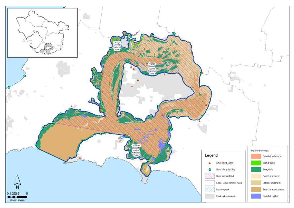
Western Port is a natural wonder with outstanding biodiversity founded on a mosaic of marine, intertidal, coastal, wetland and island environments. Western Port is a Ramsar-listed site – a wetland of international importance – and its shores are fringed by some of the world’s most southerly mangrove forests, vast intertidal mudflats, Victoria’s largest saltmarshes and sandy beaches. Beneath the water, seagrass meadows grow across Western Port’s northern and western arms around French Island. They provide critical habitat and energy for fish and the invertebrates they live on. Birdwatchers and scientists have counted 115 species of waterbirds, waders and seabirds.
Thousands of Victorians make significant contributions to protecting and improving the health and values of the marine environment. They include volunteers, Committees of Management, Coastcare groups, conservation management networks, friends’ groups, boating and fishing user groups, industry groups, management agencies, and local and state governments
An important focus of the Victorian Government is to guide and support those organisations and volunteers to manage the health of the marine and coastal environment so that ecosystems, communities and built assets are as resilient as they can be in the face of future changes including natural hazards, climate change, population growth or, most likely, a combination of these factors.
Policy and planning
The Marine and Coastal Act 2018 provides an integrated and coordinated approach to planning and managing Victoria’s marine and coastal environment. The Marine and Coastal Policy guides decision makers in the planning, management and sustainable use of Victoria’s marine and coastal environment. The first statewide Marine and Coastal Strategy includes an implementation plan identifying priority actions to be completed over the next five years, and outline responsibility for delivery and timeframes.
Responsibility for planning and development on the coasts and the seabeds of the bays generally lies with the Department of Energy, Environment and Climate Action (DEECA), which also oversees the legal accountabilities of Coastal Committees of Management along the coast.
DEECA also coordinates Protecting Victoria’s Environment – Biodiversity 2037 – the Victorian Government’s statewide strategy to protect and improve biodiversity.
The Port Phillip Bay Environmental Management Plan is the key planning document for environmental health of Port Phillip Bay. It is coordinated by DEECA and focuses action and investment on priority issues affecting Bay health.
A key document regarding ecological health in and around Western Port is the Western Port Ramsar Site Management Plan. It identifies priority threats to Western Port’s ecological character and sets management strategies, resource condition targets and monitoring arrangements.
Victoria also has a system of Marine Protected Areas. In this region there are eight marine areas. These are managed by Parks Victoria. Parks Victoria also has responsibilities as the Local Port and Waterway Manager in the bays.
The Environment Protection Authority has a responsibility to protect the uses and values of Victoria’s environment by employing a range of measures consistent with its responsibilities under the new Environment Protection Act 2017 which commenced on 1 July 2021. The Act creates duties for all Victorians to protect our environment and human health from the impacts of pollution and waste. Under the Act, the General Environmental Duty (GED) and other more specific duties will focus Victorian business, industry and the community on preventing harm. The EPA also performs several activities relevant to marine environments including monitoring recreational and marine water quality, regulating discharges to waterways and coastal waters, and reporting on the condition of the bays and catchments.
The catchment lands and coasts that feed into Port Phillip Bay and Western Port are generally managed by numerous local governments. They have a range of policies and plans in place that aim to protect and enhance the cultural, social, environmental and economic values of the marine environments. The Councils that cover the coastal areas of Port Phillip Bay cooperate through the Association of Bayside Municipalities that is focused on protecting and sustainably managing the Bay for future generations, The Councils around Western Port have cooperated to support the Mornington Peninsula and Western Port Biosphere Reserve Foundation which works with its community to create a sustainable future for Western Port.
Melbourne Water manages the waterways, wetlands and estuaries that feed into Port Phillip Bay and Western Port. The Healthy Waterways Strategy 2018-28 provides vision statements, goals and performance objectives for waterway management in those catchments.
Planning and investment for water management is also important to protect the future health of marine environments. A Central and Gippsland Region Sustainable Water Strategy has been prepared in response to new population and climate change projections, and focuses on water conservation and efficient use, greater use of recycled water and stormwater, better water-sharing arrangements and improving how water entitlements and trade can be used to better manage risks. Opportunities for holding back large stormwater flows into marine environments, and reducing nutrient and litter loads are also being explored as part of the Integrated Water Management planning for each of the Westernport, Dandenong, Yarra, Maribyrnong and Werribee catchments.
Traditional Owners are the voice of their Country
For all policy and planning, there is a need for recognition and inclusion of Traditional Owner knowledge and aspirations. The water and lands are increasingly being recognised as ‘living and integrated natural entities‘ and the Traditional Owners should be recognised as the ‘voice of these living entities’ (see target 13.1). A Country Plan is being prepared by the Bunurong Land Council Aboriginal Corporation which will describe the vision and priorities of the Traditional Owners for their area under their responsibilities as a Registered Aboriginal Party, including for Western Port and a large area of Port Phillip Bay and its eastern and northern coast. The Wadawurrung Traditional Owners Aboriginal Corporation has developed its Paleert Tjaara Dja Country Plan that seeks respectful working and learning based on cultural knowledge and practices. The plan is particularly relevant to the western areas and coast of Port Phillip Bay. The Country Plans provide a strong basis for all planning to recognise and include the voice of these Traditional Owners.
This region’s marine environments now
Water quality
Water quality in Port Phillip Bay and Western Port was assessed in the EPA Report Card 2018-19 as ‘Good’. Over the past 20 years, water quality in Port Phillip Bay has fluctuated between overall ratings of ‘Good’ to ‘Very Good’, while in Western Port the water quality has remained relatively steady since 2000 with overall annual water quality assessed as ‘Good’ for nearly all years.
Port Phillip Bay and Western Port generally have strong capacity to self-maintain good water quality. However, reducing annual nitrogen loads to Port Phillip Bay has been a focus over the past 20 years and remains so. For Western Port, reduction of sediment loads has been a priority.
Marine protected areas
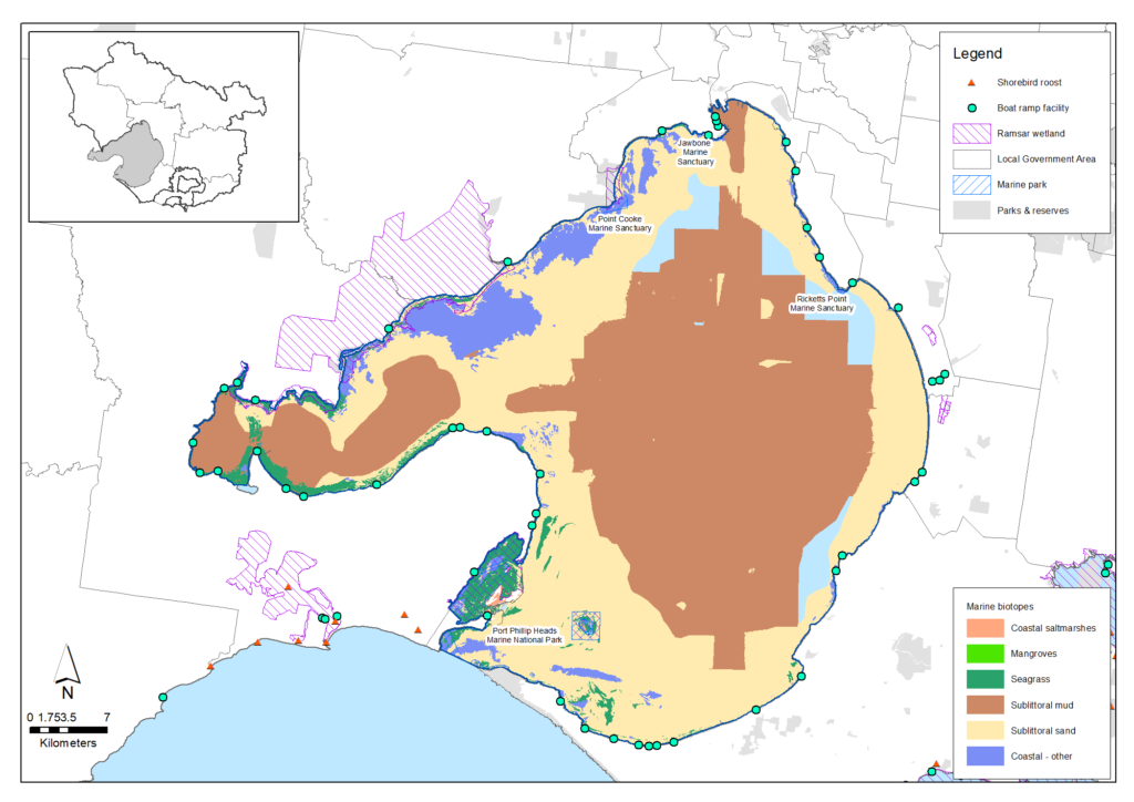
Port Phillip Bay and Western Port feature eight Marine Protected Areas managed by Parks Victoria:
- Port Phillip Heads Marine National Park
- Point Cook Marine Sanctuary
- Jawbone Marine Sanctuary
- Ricketts Point Marine Sanctuary
- Mushroom Reef Marine Sanctuary
- Yaringa Marine National Park
- French Island Marine National Park
- Churchill Island Marine National Park.
The aim of these is to protect representative marine environments. All forms of commercial and recreational fishing are prohibited in Marine Protected Areas.
Marine habitats
Port Phillip Bay has many different natural habitats. Along the foreshore are sandy beaches, rocky intertidal reefs, mud flats, mangroves and saltmarshes. Habitats within the Bay include seagrass meadows, rocky reefs, sponge gardens and unvegetated soft sediments (sands and silt). Unvegetated soft sediments on the seafloor are home to a diverse array of invertebrates and micro-organisms that are critical in processing nitrogen and other nutrients. Seagrasses provide nurseries for many fish and invertebrate species. Rocky reefs provide hard substrate on which hundreds of species of seaweed grow.
Port Phillip Bay is home to a diversity of marine plants and animals, many of which are found nowhere else. They include hundreds of species of fish, molluscs, crustaceans, marine worms, cnidarians (e.g. jellyfish and sea anemones), algae (seaweeds) and sponges. The Bay also supports populations of marine mammals, including seals and dolphins, and is frequently visited by Humpback Whales and Southern Right Whales. 33 bird species of coastal waders, seabirds and coastal birds-of-prey are commonly seen around and on the Bay.
In Western Port, important marine habitats include seagrass, intertidal sand and mudflats, rocky reefs, mangroves and saltmarsh. Seagrass extent and condition have proved highly variable over time with a significant decline in the 1970s and 1980s before a 60% recovery in more recent years. Intertidal sand and mudflats cover nearly half of the Western Port Ramsar site area. Rocky Reefs comprises a small area in Western Port, but includes the intertidal and subtidal reefs at San Remo which support a high diversity of one invertebrate group, opisthobranchs (sea-slugs and seahares), which are listed as a threatened community.
Fish diversity and abundance in Western Port reflect the quality and diversity of its habitats. Western Port is a key breeding area for some species such as Elephant Fish, School Shark and Australian Anchovy, and a nursery area for other species such as King George Whiting, Yellow-eye Mullet and Australian Salmon. Bird abundance remains a vital part of Western Port’s value, with 115 species recorded on Western Port’s coasts and intertidal areas including threatened species such as Eastern Curlew and Curlew Sandpiper.
Ramsar wetlands
There are three wetlands in this region that are internationally-recognised under the Ramsar Convention on Wetlands of International Importance (a global, intergovernmental treaty for the conservation of wetlands) for their quality and the large numbers of Australian and migratory birds that utilise them:
- Port Phillip Bay (western shoreline) and Bellarine Peninsula Ramsar site
- the Edithvale-Seaford Wetlands Ramsar site
- Western Port Ramsar site
For more information on the region’s Ramsar-listed wetlands, visit the ‘Wetlands’ Theme section of this website.
Marine pests
Marine pests pose a critical threat to Port Phillip Bay’s ecological health. Agriculture Victoria reports that at least 99 pest species have been introduced to the Bay from known origins. A further 61 marine species have also been observed but are of unknown origin.
Pest organisms vary in size from large plants to micro-organisms and include algae, fishes, polychaetes, rotifers, nematodes, crustaceans, ascidians, bryozoans, bivalves, gastropods, hydroids and ciliates. Some, like Sabella worm and Undaria kelp, can dominate space and out-compete native species. Northern Pacific Seastars are voracious predators or have adverse impacts on fish habitat and food chains. Dinoflagellate species can cause toxic algal blooms.
In Western Port, invasive Cord-grass (Spartina spp.) is a highly invasive weed capable of displacing native plants and saltmarsh, disrupting food webs and occupying coastal and estuarine habitats above and below the high tide mark. Spartina anglica and Spartina × townsendii have invaded the northern shoreline around the Inlets and Bass River and could become more widespread. Spartina control is a high priority activity for Melbourne Water in estuaries and Parks Victoria in marine and coastal protected areas. But the Understanding the Western Port Environment report indicated that few studies have been undertaken on Spartina in Western Port, and that little is known of its environmental impacts there.
Two marine pest species of concern are already established in Western Port or may spread there in the future. The New Zealand screw shell, Maoricolpus roseus, is already present in Bass Strait. M. roseus has been found in high densities in Point Hicks Marine National Park. Anecdotal evidence suggests that it has reduced the diversity of aquatic fauna at this site.
Recreational fishing
Fishing for fun is a major activity on Port Phillip Bay. Over a half a million fishing trips were taken across the whole Port Phillip region in 2018, the vast majority on Port Phillip Bay producing an estimated economic value of over $420 million per year. This fishing effort appears sustainable for now. Fisheries Research & Development Corporation studies (2017) found fishing in Port Phillip Bay to be a much lower risk to the Bay’s ecological health than water pollution, coastal development and marine pest species.
Similarly, Western Port is a famous recreational fishery. Regular catches include whiting and school shark over seagrass meadows and snapper, Australian salmon, snook and barracouta in open waters.
Many recreational anglers know their sport depends on the health of the region’s bays and waterways. OzFish is one of several organisations supporting recreational fishers in practical projects to restore fish habitat.
Aquaculture
The region is also home to a large aquaculture sector, focused primarily on Blue Mussel and cage Abalone. Aquaculture sites in the region include the Beaumaris Aquaculture Fisheries Reserve, the Dromana Aquaculture Fisheries Reserve and the Mount Martha Aquaculture Fisheries Reserve, all in Port Phillip Bay, and the Flinders Aquaculture Fisheries Reserve in Western Port Bay. The reserves total 437 hectares. Individual farming sites ranging from 3 hectares to 27 hectares.
Port Phillip Bay accounts for about 90% of mussel aquaculture in Victoria. The state-wide industry produced 1,014 tonnes of mussels worth over $3 million in 2017.
More information
Further information on condition of Port Phillip Bay and Western Port is outlined in their pages in the Local Areas section of this website.
Key challenges and drivers of change
The health of the marine environment is under threat from multiple sources, including
climate change and growth in towns, cities and industries that interact with their local marine ecosystems. These threats can lead to negative impacts on water quality and quantity, pollution and debris, invasive species, marine pests and diseases, and disturbance and loss of plants and animals. Degradation occurs over time and the impacts in marine areas are varied and complex.
Key drivers of change identified for the marine environment are population growth and climate change.
Population growth
Victoria has been experiencing record population growth with suburbs and towns around Port Phillip Bay and within two hours’ drive of Melbourne (including on the Bellarine Peninsula, Mornington Peninsula and Bass Coast) recording big increases in both population size and density. Growth in the permanent population has been accompanied by big increases in numbers of domestic, national and international visitors to coastal areas.
Growth in resident populations and visitor numbers puts pressure on the health of the marine environment with direct impacts including:
- Habitat loss and degradation
- Increased introduction of invasive and pest species
- Increased pollution from sources including litter, stormwater runoff, wastewater discharges .and plastic pollution and microplastics.
Seagrass beds, estuarine mudflats and mangroves are amongst the most vulnerable habitat types as they require sheltered environments that are at increased risk from nutrients and contaminants transported by storm water. These specialised habitats are critical for all or some life cycle stages of many marine species.
Population growth also increases pressure for growth in marine industries – such as seafood, energy generation and resource extraction – and for transportation of their produce across Australia and overseas.
Climate change
Climate change is increasing the pressure on the region’s marine environment by exacerbating existing threats and introducing new ones such as:
- Rising sea levels, leading to more inundation and erosion
- Increased frequency and severity of storms and other extreme weather events
- Changes in ocean temperatures, currents and acidification
- Changes to waterway flows, levels and regimes
- Changes in the range, distribution and abundance of both introduced and native plants and animals, taking advantage of a changed climate
- Coastal squeeze, which occurs when coastal ecosystems forced inland by rising sea levels run into human-made barriers such as roads and housing.
To help achieve net zero carbon emissions, there may be significant opportunities for capture and storage of ‘blue carbon’ in the wetland, coastal, estuarine and marine environments in this region, and these may have additional benefits for biodiversity, water quality and marine health.
More information
Further information on threats to the health of Port Phillip Bay and Western Port is outlined in their pages in the Local Areas section of this website.
Vision and targets for the future
Vision
The Marine and Coastal Policy includes the following vision:
Our vision is for a healthy, dynamic and biodiverse marine and coastal environment that is valued in its own right, and that benefits the Victorian community, now and in the future.
and objectives:
- protect and enhance the marine and coastal environment
- promote the resilience of marine and coastal ecosystems, communities and assets to climate change
- respect natural processes in planning for and managing current and future risks to people and assets from coastal hazards and climate change
- acknowledge Traditional Owner groups’ knowledge, rights and aspirations for Land and Sea Country
- promote a diversity of experience in the marine and coastal environment
- promote the ecologically sustainable use and development of the marine and coastal environment and its resources in appropriate areas
- improve community, user group and industry stewardship and understanding of the marine and coastal environment
- engage with specified Aboriginal parties, the community, user groups and industry in marine and coastal planning, management and protection
- build scientific understanding of the marine and coastal environment.
Regional Catchment Strategy targets
The following targets will contribute to achieving the vison for the marine environments and help ensure they remain healthy and valuable for future generations.
Target 12.1 – Marine water quality
Target 12.2 – Marine parks
Target 12.3 – Marine habitats
12.4 – Marine pests
12.5 – Fisheries
Progress toward the marine water quality target will be monitored primarily through annual data and reports from the Environment Protection Authority and Melbourne Water.
Progress toward the marine parks target will be monitored primarily through information developed and published by Parks Victoria as part of its role in managing marine protected areas.
Progress toward the marine habitat and marine pests targets will be monitored primarily using information developed and published by the Department of Energy, Environment and Climate Action as part of its statewide marine and coastal programs.
Progress toward the fisheries target will be monitored primarily using information developed and published by Fisheries Victoria and the Department of Energy, Environment and Climate Action.
Partner organisations for the journey ahead
The following organisations formally support the pursuit of the visions and targets for marine environments. They have agreed to provide leadership and support to help achieve optimum results with their available resources, in ways such as:
- Fostering partnerships and sharing knowledge, experiences and information with other organisations and the community
- Seeking and securing resources for the area and undertaking work that will contribute to achieving the visions and targets
- Assisting with monitoring and reporting on the condition of the area.
Victorian Government
- Department of Energy, Environment and Climate Action (DEECA)
- Melbourne Water
- Victorian Fisheries Authority
- Phillip Island Nature Parks
- Yarra Valley Water
- South East Water
- Parks Victoria
- Environment Protection Authority Victoria (EPA)
- Trust for Nature
- Sustainability Victoria
- Westernport Water
- Zoos Victoria
Local Government
- Association of Bayside Municipalities
- Wyndham City
- Moorabool Shire Council
- Bayside City Council
- City of Port Phillip
- Kingston City Council
- Glen Eira City Council
- City of Stonnington
- Knox City Council
- Maroondah City Council
- Cardinia Shire Council
- Baw Baw Shire Council
- Bass Coast Shire Council
- Eastern Alliance for Greenhouse Action
- Whitehorse City Council
- City of Casey
- South Gippsland Shire Council
- Hume City Council
- City of Whittlesea
- Moonee Valley City Council
- Hobsons Bay City Council
- City of Greater Geelong
- Western Alliance for Greenhouse Action
- Northern Alliance for Greenhouse Action
- South East Councils Climate Change Alliance
Traditional Owners
- Wadawurrung Traditional Owners Aboriginal Corporation
- Bunurong Land Council Aboriginal Corporation
Non Government
- The Nature Conservancy
- Birdlife Australia
- Conservation Volunteers Australia
- Marine Mammal Foundation
- Western Port Seagrass Partnership
- Habitat Restoration Fund
- Victorian National Parks Association
- Dolphin Research Institute
- Native Fish Australia (Vic)
- OzFish Unlimited
- The People and Parks Foundation
- Field Naturalists Club of Victoria
Community
- Port Phillip EcoCentre
- Werribee River Association
- NatureWest
- Little River Community Landcare Inc
- Friends of Lower Kororoit Creek Inc
- Northern Yarra Landcare Network
- Nillumbik Landcare Network
- Cardinia Environment Coalition
- Phillip Island Landcare Group
- Western Port Catchment Landcare Network
- Gippsland Threatened Species Action Group
- Bass Coast Landcare Network
- French Island Landcare Group
- South Gippsland Landcare Network
- Loch-Nyora Landcare Group
- Mt. Lyall Landcare Group
- Poowong & District Landcare Group
- Triholm Landcare Group
- Main Creek Catchment Landcare Group
- Merricks Coolart Catchment Landcare Group
- Westernport Swamp Landcare Group
Add your organisation as a supporter and partner
If your organisation supports these directions and targets for marine environments, it can be listed as a partner organisation. Adding your organisation to this list will:
- Enable your organisation to list one or more priority projects in the Prospectus which will describe how your priority project will pursue the targets of this Regional Catchment Strategy and potentially make your organisation’s project more attractive to investors by using the strategy to highlight its relevance and value
- Demonstrate your commitment to a healthy and sustainable environment
- Demonstrate the level of community engagement and support for this work.
Priority projects to move forward
Priority projects
There are significant ongoing programs and initiatives undertaken by many organisations in this region that are vital for protecting and enhancing marine environments. These include programs led by Councils, Melbourne Water, Parks Victoria, the Department of Energy, Environment and Climate Action, community groups and non-Government organisations. In addition, there are numerous projects considered to be priorities by the organisations and communities involved in managing marine environments that, if funded and implemented, can contribute to achieving the Regional Catchment Strategy’s targets. Projects include:
- Project Burrunan led by the Marine Mammal Foundation
- Kelp habitat in Port Phillip Bay proposed by OzFish Unlimited
- New shellfish reefs for Port Phillip Bay led by The Nature Conservancy
- Seagrass meadows for Western Port proposed by OzFish Unlimited
- Mulloway investigations led by Melbourne Water
- Patterson River Litter Trap led by Melbourne Water
- Western Port Biosphere Blue Carbon proposed by the Mornington Peninsula and Western Port Biosphere Foundation.
A list of project proposals across the region and their key details can be viewed in the Prospectus section of this Regional Catchment Strategy.
Propose a new priority project
As part of the ongoing development and refinement of this Regional Catchment Strategy, additional priority projects may be considered for inclusion in the Prospectus.
If your organisation supports the directions and targets for marine environments, and has a project it would like highlighted and supported in this Regional Catchment Strategy, please submit a Prospectus Project Proposal.

