Locally, regionally, internationally important
There are over 14,000 natural wetlands in our region (Healthy Waterways Strategy, 2018). Wetlands are some of the most abundant environments on earth and provide important ecological services and values. They are important plant habitats which, in turn, support feeding and breeding for birds and animals. Wetlands are natures water purifiers. They protect water quality in the region’s rivers and bays by detaining flood flows, filtering, storing and recycling sediments and nutrients.
Many wetlands occur where groundwater comes to the surface. These connections support groundwater recharge and make wetlands reliable habitat refuges during droughts.
Many of our wetlands contain very significant and rare vegetation communities such as the Environment Protection and Biodiversity Conservation Act-listed Seasonal Herbaceous Wetlands, and saltmarshes. Thousands of migratory birds travel annually to wetlands alongside Port Phillip Bay and Western Port from as far away as Alaska, Siberia, China and Japan.
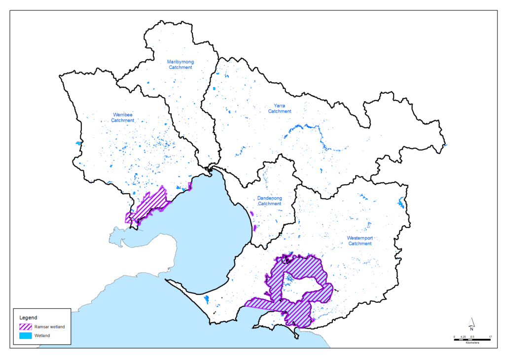
The region includes three wetland complexes which are listed under the Ramsar Convention on Wetlands of International Importance (a global, intergovernmental treaty for the conservation of wetlands):
- Western Port
- Edithvale-Seaford Wetlands
- Port Phillip (Western Shoreline) and Bellarine Peninsula
All wetlands are highly important from a cultural perspective, having a significant meaning for Traditional Owners. Some wetlands have high amenity and liveability value where people like to walk and birdwatch. Some wetlands are constructed, playing a key role in flood mitigation and water quality management.
Despite the many values of wetlands, many wetlands are under threat from urban development, climate change and other pressures.
Policy and planning
There are a number of agencies, organisations, groups and community sectors, as well as individual landholders, that have a role in the protection and management of wetlands.
The Environment Protection Authority has a responsibility to protect the uses and values of Victoria’s environment by employing a range of measures consistent with its responsibilities under the new Environment Protection Act 2017 which commenced on 1 July 2021. The Act creates duties for all Victorians to protect our environment and human health from the impacts of pollution and waste. The EPA also performs several activities relevant to wetlands including monitoring recreational and marine water quality, regulating discharges to waterways and coastal waters, and reporting on the condition of the bays and catchments.
The Victorian Government’s Water for Victoria and the Victorian Waterway Management Strategy, provide the state-wide policy framework for water and waterway management. The Victoria Planning Provisions also set out policy for land use change related to natural wetlands and their protection.
In the Port Phillip and Western Port region, Melbourne Water is the designated waterway management authority and ‘caretaker of river health’. Melbourne Water has led the development of the Healthy Waterways Strategy 2018-28 which outlines this region’s contribution to meeting the state-wide aims and establishes the vision for the health of rivers, estuaries and wetlands in the Port Phillip and Western Port region.
Parks Victoria and Melbourne Water are the region’s most significant wetland managers. Parks Victoria has important responsibilities for the Port Phillip Bay (Western Shoreline) and Bellarine Peninsula wetlands at Point Cook/Cheetham, Werribee/Avalon, Point Wilson/Limeburners Bay, Swan Bay, Mud Islands and the Lake Connewarre Complex. It is also the major partner for the Western Port Ramsar site and sole manager for associated National and Marine Parks and Nature Conservation Reserves. Melbourne Water has core responsibility for the Seaford-Edithvale Wetlands Ramsar site and for the highly significant wetlands associated with the Western Treatment Plant. The Western Port Ramsar Site and Port Phillip Bay (Western Shoreline Ramsar Site Management Plans identify the priority threats to ecological character, prescribe management actions, targets and monitoring arrangements for these wetlands.
Traditional Owners are the voice of their Country
In all policy and planning processes, the knowledge held by Traditional Owners and Aboriginal Victorians is being increasingly valued, and the influence and involvement of Traditional Owners in planning and management is increasing (see target 13.1). There is recognition that the waterways and lands are interconnected ‘living entities’ and that the Traditional Owners are the ‘voice of the living entities’ on their Country.
Wetlands hold many Aboriginal cultural values as they have been important places of food, water and materials for many thousands of years for Traditional Owners. The Country Plans of the Bunurong, Wurundjeri Woi-wurrung and Wadawurrung Registered Aboriginal Parties are expected to highlight the need for protection of natural wetlands and associated cultural heritage. The plans will describe the vision and priorities of the Traditional Owners for Country in line with their roles as Registered Aboriginal Parties, and will provide a strong basis for all other planning to recognise and include the voice of these Traditional Owners.
There is still work to be done for Traditional Owners to re-engage with Country before discussions about values occur. Traditional Owners need support in reclaiming and reengaging with Country and then utilising their traditional knowledge.
Condition of the region’s wetlands
Much like rivers, many of the region’s wetlands have been modified for urban settlement and agriculture. The draining of Koo Wee Rup Swamp from the late 1800s to the early 1900s converted around 40,000 hectares of paperbark and grassland swamp to agricultural land. It was drained through the construction of a large network of channels which feed into Western Port.
Other wetlands across the region have similarly been drained and modified to improve access, land availability, flooding control and amenity. Many inner Melbourne and coastal suburbs have been built on ‘reclaimed’ wetlands, and encroaching urban development continues to pose a threat to ephemeral wetlands.
There are over 14,000 natural wetlands within the region. These include coastal wetlands, dominated by salt tolerant vegetation, ephemeral wetlands on the Victorian Volcanic Plain which may be dry for significant periods, and billabong wetlands on the floodplains which are filled intermittently when rivers spill their banks. A regional map is below but go to the interactive Regional map to explore the wetlands in more detail.
Throughout the region, there are now also more than 370 constructed stormwater treatment wetlands that provide habitat for wildlife and areas of high amenity for residents.
The condition of wetlands across the region is outlined in the Healthy Waterways Strategy and summarised below.
Westernport catchment
Wetlands bird value in the Westernport catchment is on average very low and is likely to remain at this level. However, wetlands in the Western Port Ramsar site are recognised for their significance as bird habitat and this will be maintained in the long term. Bird habitat at coastal wetlands may be severely impacted by the predicted impacts of climate change which may impact wetland watering regimes, salinity regimes and vegetation communities. Target is to improve bird scores for wetlands from very low to low.
Fish score for wetlands is high, with a current trajectory of low. However, a number of wetlands in the Westernport catchment support the nationally-listed Dwarf Galaxias and other significant species. Work to re-engage floodplain wetlands will further improve the fish status to protect these species in additional wetlands. Target is to improve from high to very high for wetlands.
Frogs score for wetlands in the Westernport catchment is currently high with a significant decline to low predicted. However, actions to reduce the threats of water regime change, lack of wetland buffers and poor wetland vegetation condition may mitigate some of the risk posed by climate change and urbanisation. Target is to maintain at high for wetlands.
Wetland vegetation is currently considered moderate with a current trajectory of low. Implementing programs to improve wetland buffers, vegetation condition and water regime is predicted to improve the vegetation value score to an average of high for wetlands.
Assessment of wetland values and conditions in the Westernport catchment at 2018 (from the Healthy Waterways Strategy)
| Wetland values | 2018 state | 2018 trajectory | 2068 target |
|---|---|---|---|
| Birds | Very low | Very low | Low |
| Fish | High | Low | Very high |
| Frogs | High | Low | High |
| Vegetation | Moderate | Low | High |
| Wetland conditions | 2018 state | 2018 trajectory | 2068 target |
|---|---|---|---|
| Water regime | Low | Low | Moderate |
| Wetland habitat form | Moderate | Low | Moderate |
| Wetland buffer condition | Low | Low | High |
| Vegetation condition | Low | Low | High |
| Wetland water quality | Low | Very low | Moderate |
Dandenong catchment
Wetlands bird score in the Dandenong catchment is on average currently low. In the long term the wetland bird score will be maintained at low. Improvements to wetland water regimes, habitat form, buffer and vegetation condition will help to mitigate the impacts of climate change and urbanisation, but will not result in significant improvements to the score. Significant bird values will remain at the Edithvale-Seaford wetlands.
A number of wetlands in the Dandenong Catchment support the nationally-listed Dwarf Galaxias and more recently reintroduced Yarra Pygmy Perch. These wetlands will retain a fish status of very high due to the ongoing presence of these species.
Frogs score is currently low with a current and target trajectory of moderate. Many wetlands in the catchment provide habitat for significant frog species and these areas will be targeted to maintain their very high frog value scores. Improvements to wetland water regime, wetland habitat form and vegetation condition will help to improve frog populations. However, at some coastal wetland sites, increasing salinity associated with predicted climate change impacts may impact the frog score at these sites.
Wetland vegetation score is currently considered low. However, there is potential to increase the vegetation score to moderate in the long term. Improvements to the wetland water regimes and wetland habitat form, along with actions to reduce the threat of invasive plant and animal species will improve the vegetation score.
Assessment of wetland values and conditions in the Dandenong catchment at 2018 (from the Healthy Waterways Strategy)
| Wetland values | 2018 state | 2018 trajectory | 2068 target |
|---|---|---|---|
| Birds | Low | Low | Low |
| Fish | Very high | Very high | Very high |
| Frogs | Low | Moderate | Moderate |
| Vegetation | Low | Low | Moderate |
| Wetland conditions | 2018 state | 2018 trajectory | 2068 target |
|---|---|---|---|
| Water regime | Low | Low | Moderate |
| Wetland habitat form | Low | Low | Moderate |
| Wetland buffer condition | Very low | Very low | Moderate |
| Vegetation condition | Low | Low | Moderate |
| Wetland water quality | Low | Very low | Moderate |
Yarra catchment
Wetland bird score in the Yarra catchment is on average currently very low. However, some wetlands such as Cockatoo Swamp have high bird values. Environmental watering of key billabongs in the Yarra catchment is predicted to improve the bird value of many billabong wetlands. The target is to improve from very low to low.
Fish score is currently low overall. However, environmental watering of key billabongs and re-ngagement of floodplain wetlands in the long term is predicted to significantly improve the fish score up to high.
Frogs score is high. Actions to reduce the threats of changed water regimes, altered wetland form, lack of wetland buffers and poor wetland vegetation condition will maintain the score at high, particularly in the Yarra billabongs. Many Yarra wetlands provide habitat for significant frog species such as Growling Grass Frog. It is predicted that these habitats will continue to support these species.
Vegetation score is currently low. Actions to reduce the threats of changed water regimes, improve vegetation condition and wetland habitat form will improve the wetland vegetation score to a potential trajectory of moderate.
Assessment of wetland values and conditions in the Yarra catchment at 2018 (from the Healthy Waterways Strategy)
| Wetland values | 2018 state | 2018 trajectory | 2068 target |
|---|---|---|---|
| Birds | Very low | Low | Low |
| Fish | Low | High | High |
| Frogs | High | Moderate | High |
| Vegetation | Low | Low | Moderate |
| Wetland conditions | 2018 state | 2018 trajectory | 2068 target |
|---|---|---|---|
| Water regime | Low | High | High |
| Wetland habitat form | Low | Low | Low |
| Wetland buffer condition | Very low | Low | High |
| Vegetation condition | Low | Moderate | High |
| Wetland water quality | Low | Very low | Moderate |
Maribyrnong catchment
Wetland bird score is currently very low across the catchment. Some improvements to wetland water regime, habitat form and vegetation condition may improve the score in some areas. However, the impacts of climate change and reduced periods of wetlands inundation, and the extensive urban growth in the catchment will continue to provide risk to birds. The overall target is to improve from very low to low.
Frogs score for wetlands is currently low and is predicted to remain low, as decreased frequency and duration of wetlands inundation will affect the frog community. However, improvements to wetland water regime, habitat form and vegetation condition will enable the frog score to increase to moderate.
Wetland vegetation score is currently very low overall. Decreased frequency and duration of wetland inundation will impact the vegetation condition. However, improvements to wetland water regime, habitat form and vegetation condition will somewhat mitigate the predicted impacts of climate change and urban growth and enable the vegetation score to increase to low for wetlands.
Assessment of wetland values and conditions in the Maribyrnong catchment at 2018 (from the Healthy Waterways Strategy)
| Wetland values | 2018 state | 2018 trajectory | 2068 target |
|---|---|---|---|
| Birds | Very low | Very low | Low |
| Fish | |||
| Frogs | Low | Low | Moderate |
| Vegetation | Very low | Very low | Low |
| Wetland conditions | 2018 state | 2018 trajectory | 2068 target |
|---|---|---|---|
| Water regime | Very low | Very low | Low |
| Wetland habitat form | Low | Low | Low |
| Wetland buffer condition | Very low | Very low | Low |
| Vegetation condition | Very low | Very low | Moderate |
| Wetland water quality | Very low | Very low | Low |
Werribee catchment
Wetlands bird score is currently low. However, there are many wetlands in the Werribee catchment that are recognised for their significance as bird habitat including Cheetham Wetlands, The Spit Nature Conservation Reserve, Western Treatment Plant and Point Cook Wetlands (RAAF and Spectacle Lakes). Bird habitat at coastal wetlands may be severely impacted by the predicted impacts of climate change which may affect wetland watering regimes, salinity regimes and vegetation communities.
Frogs score is currently high, with a current trajectory of very low. Significant decline to wetland water regimes and water quality as a result of urbanisation and climate change impacts will affect frogs. Actions to reduce these threats may somewhat mitigate these impacts and retain the frog score at moderate.
Vegetation score is currently low. Implementing programs to improve wetland buffers, vegetation condition and habitat form is predicted to improve this score to moderate. Forward planning for adaption and migration of coastal wetland and estuarine vegetation is essential in light of predicted climate change impacts.
Assessment of wetland values and conditions in the Werribee catchment at 2018 (from the Healthy Waterways Strategy)
| Wetland values | 2018 state | 2018 trajectory | 2068 target |
|---|---|---|---|
| Birds | Low | Very low | Low |
| Fish | |||
| Frogs | High | Very low | Moderate |
| Vegetation | Low | Very low | Moderate |
| Wetland conditions | 2018 state | 2018 trajectory | 2068 target |
|---|---|---|---|
| Water regime | Moderate | Very low | Low |
| Wetland habitat form | Very low | Very low | Moderate |
| Wetland buffer condition | Very low | Very low | Very high |
| Vegetation condition | Low | Low | Moderate |
| Wetland water quality | Moderate | Very low | Low |
Ramsar wetlands
The Port Phillip and Western Port region includes the following three wetland complexes which are listed under the Ramsar Convention on Wetlands of International Importance (a global, intergovernmental treaty for the conservation of wetlands).
Western Port
Western Port is a large bay incorporating around 260 kilometres of coastline, connected to Bass Strait by a wide channel between Flinders and Phillip Island, and a narrow channel between San Remo and Phillip Island. Six rivers from the north and east of the catchment flow into the northern and eastern shores of Western Port and several minor rivers and creeks on the eastern slopes of the Mornington Peninsula drain into the western shores.
The wetlands have a wide variety of habitat types, ranging from deep channels, seagrass flats, intertidal mudflats, extensive mangrove thickets and saltmarsh vegetation. The white mangrove communities within Western Port are the most well-developed and extensive in Victoria, and are the only large communities situated so far from the Equator. Threatened plant species that are found within the site include Dense Leek-orchid, Creeping Rush, and Tiny Arrow Grass.
Western Port is one of the three most important areas for waders in Victoria and the site supports numerous migratory species listed under international migratory bird conservation agreements. High numbers of Eastern Curlew, Whimbrel, Bar-tailed Godwit, Grey-tailed Tattler, Greenshank and Terek Sandpiper have been recorded at the site. Nationally threatened species that utilise Western Port include the Orange-bellied Parrot, Swift Parrot, Helmeted Honeyeater, Little Tern, Southern Right Whale, and Humpback Whale. The site supports the globally threatened Fairy Tern which is listed as vulnerable on the IUCN Red List of Threatened Species.
Edithvale-Seaford Wetlands
The Edithvale-Seaford wetlands are the last remnants of the once extensive Carrum Carrum Swamp, a large inter-dunal lagoon that was largely drained in the late 19th century. The site is used for flood control, conservation, recreation and education.
The wetlands are naturally fresh to brackish marshes and open water wetlands, underlain by peat beds that limit the entry of saline groundwater. Both wetlands receive waters from the surrounding urban and semi-rural catchment and discharge to Port Phillip Bay via drains.
The wetlands provide habitat in an urban setting for remnant species, supporting a range of native and introduced vegetation. A total of 202 plant species have been recorded for the wetlands, including a significant extension to the range of the native Southern Water Ribbons.
Remnant habitats support a variety of native bird, mammal, frog, reptile, fish and invertebrate populations, several of which are of regional and state conservation significance. Seaford Swamp is a site of international importance for the Sharp-tailed Sandpiper.
Port Phillip (Western Shoreline) and Bellarine Peninsula.
The Port Phillip Bay (Western Shoreline) and Bellarine Peninsula wetlands are located in the western portion of Port Phillip Bay, near the city of Geelong in Victoria. The site comprises six distinct areas that include Point Cook/Cheetham, Werribee/Avalon, Point Wilson/Limeburners Bay, Swan Bay, Mud Islands, and the Lake Connewarre Complex.
The site is a low-lying area and a natural discharge point for the rivers draining southern central Victoria. The tidal amplitude within the bay is reduced compared with Bass Strait due to the narrow opening of the Bay (Port Phillip Heads).
Port Phillip Bay (Western Shoreline) and Bellarine Peninsula support a variety of wetland types ranging from shallow marine waters to seasonal freshwater swamps and extensive sewage ponds. Wetland areas include freshwater lakes, estuaries, some with White Mangrove, saltmarshes, intertidal mudflats and seagrass beds and supports some plants species threatened in Victoria, such as Small Scurf-pea and Rare Bitter-bush.
This site is the sixth most important area in Australia for migratory waders and the most important in Victoria. Large numbers of bird species including Pied Oystercatchers, Banded Stilts, Red-necked Stint, Sharp-tailed Sandpiper, Fairy Tern, Australasian Shoveler, Red-necked Avocets, Blue-billed Duck, and Freckled Duck, have been recorded at the site. Furthermore, Melbourne Water’s Western Treatment Plant at Werribee supports many waterbirds on its retention ponds.
Port Phillip Bay (Western Shoreline) and Bellarine Peninsula provides important habitat for threatened species such as the Little Tern and Striped Legless Lizard. In particular, large numbers of the nationally threatened Orange-bellied Parrot utilise Port Phillip Bay during the winter after their summer migration to Tasmania to breed. Swan Bay and Limeburners Lagoon are also valuable fish breeding grounds for many of the commercial species caught in Port Phillip Bay.
Key challenges
Climate change and sea level rise
Climate change leads to changes in rainfall, higher temperatures and greater evaporation. This means surface and groundwater supply drop, putting more pressure on wetland plants and animals.
Other climate change effects on wetlands include:
- More frequent bushfires will reduce water quality and catchment inflows
- Increasing water temperatures and reduced flows will damage wetlands as natural environments
- More intense rainfall and ‘flash’ floods will do environmental damage to wetlands.
Poor water quality
Pollutants such as pesticides, pathogens, excess sediment and heavy metals threaten environmental values. Litter and unsightly smells and odours detract from social values.
Vegetation clearing
Vegetation removal reduces feeding and breeding habitat for environmental values, changes the temperature and light within wetlands, which affects aquatic habitats, and reduces the sense of naturalness that contributes to amenity.
Pest plants and animals
Pest animals threaten all environmental values. Foxes, feral dogs and feral cats prey on birds, reptiles and mammals living in and around wetlands. Grazing and browsing animals such as rabbits and deer reduce the cover of indigenous plants and prevent the establishment of new plants. Pest plants displace indigenous vegetation which can have profound impact on the healthy functioning of wetlands.
Urbanisation
Urban development is a major threat to natural wetlands. Limited community awareness and understanding of the presence and values of ephemeral wetlands places them at particular risk. Urbanisation and poor urban community understanding also lead to damage from inappropriate estuary openings, vegetation clearing and poorly restrained domestic dogs and cats.
Changed hydrology of natural wetlands from increased stormwater flows as an outcome of urban development is also a key challenge in the region. As vegetated surfaces are replaced with hard impervious surfaces (such as roofs, roads and paved areas) that drain directly into wetlands via stormwater systems, there are increases in runoff (changed water flow rates) and reduced water quality. There can also be reduced groundwater recharge due to increased impervious surfaces reducing the ability of groundwater dependent ecosystems to function.
Vision and targets for the future
Vision
The Healthy Waterways Strategy outlines the following 50-year vision which relates to waterways, wetlands and estuaries of this region:
Healthy and valued waterways are integrated with the broader landscape, and enhance life and liveability. Waterways connect diverse and thriving communities of plants and animals; provide amenity to urban and rural areas, and engage communities with their environment; and are managed sustainably to enhance environmental, economic, social and cultural values.
The Healthy Waterways Strategy also provides catchment-scale visions as summarised below.
Targets
Following is a small selection of targets for wetlands drawn from the Healthy Waterways Strategy. More detail on the ratings of waterways are available in the Healthy Waterways Strategy. Progress towards these targets will be primarily monitored through the ongoing Healthy Waterways Strategy monitoring and reporting program led by the Melbourne Water.
Target 3.1 – Wetlands water regime
Target 3.2 – Wetlands vegetation
Target 3.3 – Wetlands water quality
Target 3.4 – Ramsar wetlands
In regard to the Ramsar wetlands of this region, the following target recognises the special importance and responsibilities that exist to preserve the ecological character and condition of these wetlands.
Progress towards this target will be primarily monitored through the ongoing Ramsar coordination and monitoring programs for these sites led by the Department of Energy, Environment and Climate Action and Melbourne Water.
Partner organisations
The following organisations formally support the pursuit of the Regional Catchment Strategy’s visions and targets for wetlands. They have agreed to provide leadership and support to help achieve optimum results with their available resources, in ways such as:
- Fostering partnerships and sharing knowledge, experiences and information with other organisations and the community
- Seeking and securing resources for the area and undertaking work that will contribute to achieving the visions and targets
- Assisting with monitoring and reporting on the condition of the area.
Victorian Government
- Melbourne Water
- Department of Energy, Environment and Climate Action (DEECA)
- Parks Victoria
- Phillip Island Nature Parks
- Sustainability Victoria
- Victorian Fisheries Authority
- Trust for Nature
- Environment Protection Authority Victoria (EPA)
- Yarra Valley Water
- South East Water
- South Gippsland Water
- Westernport Water
- Zoos Victoria
Local Government
- Hume City Council
- City of Whittlesea
- Macedon Ranges Shire Council
- Wyndham City
- Moorabool Shire Council
- Brimbank City Council
- Moonee Valley City Council
- Monash City Council
- Glen Eira City Council
- Kingston City Council
- City of Stonnington
- Knox City Council
- City of Casey
- Cardinia Shire Council
- Baw Baw Shire Council
- City of Melbourne
- Maroondah City Council
- City of Greater Geelong
- Hobsons Bay City Council
- City of Greater Dandenong
- Whitehorse City Council
- Bass Coast Shire Council
- South Gippsland Shire Council
- Eastern Region Pest Animal Network
- Western Alliance for Greenhouse Action
- Northern Alliance for Greenhouse Action
- Eastern Alliance for Greenhouse Action
- South East Councils Climate Change Alliance
Traditional Owners
- Wadawurrung Traditional Owners Aboriginal Corporation
- Bunurong Land Council Aboriginal Corporation
Non Government
- The Nature Conservancy
- Birdlife Australia
- Conservation Volunteers Australia
- Dolphin Research Institute
- Western Port Biosphere Reserve Foundation
- Victoria Walks
- Field Naturalists Club of Victoria
- Victorian National Parks Association
- Native Fish Australia (Vic)
- OzFish Unlimited
- Port Phillip EcoCentre
- Gardens for Wildlife Victoria
- The People and Parks Foundation
- Western Port Seagrass Partnership
- Habitat Restoration Fund
Community
- Werribee River Association
- Federation for Environment and Horticulture in the Macedon Ranges
- Upper Deep Creek Landcare Network
- Jacksons Creek EcoNetwork
- Greening of Riddell
- Friends of Emu Bottom Wetlands Reserve
- Friends of Daly Nature Reserve
- Deep Creek Landcare Group
- Riddells Creek Landcare Group
- Newham and District Landcare Group
- Merri Creek Management Committee
- Darebin Creek Management Committee
- Yarra Ranges Landcare Network
- Northern Yarra Landcare Network
- Nangana Landcare Network
- Johns Hill Landcare Group
- Nillumbik Landcare Network
- NatureWest
- Friends of Lower Kororoit Creek Inc
- Hobsons Bay Wetlands Centre Inc.
- Gippsland Threatened Species Action Group
- Kooyongkoot Alliance
- Friends of Dandenong Valley Parklands
- Cardinia Environment Coalition
- Bass Coast Landcare Network
- Bass Valley Landcare Group
- South Gippsland Landcare Network
- Loch-Nyora Landcare Group
- Mt. Lyall Landcare Group
- Poowong & District Landcare Group
- Triholm Landcare Group
- Phillip Island Landcare Group
- Western Port Catchment Landcare Network
- Westernport Swamp Landcare Group
- Mornington Peninsula Landcare Network
- Main Creek Catchment Landcare Group
- Merricks Coolart Catchment Landcare Group
- Sheepwash Creek Catchment Landcare Group
- Manton and Stony Creeks Landcare Group
- Mornington Peninsula Koala Conservation
Add your organisation as a supporter and partner
If your organisation supports these directions and targets for wetlands and wishes to be listed as a partner organisation, you can request to be listed as a partner organisation. Adding your organisation to this list will:
- enable your organisation to list one or more priority projects in the Prospectus which will describe how your priority project will pursue the targets of this Regional Catchment Strategy and potentially make your organisation’s project more attractive to investors by using the strategy to highlight its relevance and value
- demonstrate your commitment to a healthy and sustainable environment
- demonstrate the level of community engagement and support for this work.
Priority projects to move forward
Priority projects
There are significant ongoing programs and initiatives undertaken by many organisations in this region that are vital for protecting and enhancing wetlands and are priorities to continue. In addition, there are numerous project proposals that, if funded and implemented, can contribute to achieving the Regional Catchment Strategy’s visions and targets. Project proposals include:
- The Spit Saltmarsh Restoration Project proposed by Melbourne Water
- Western Port Ramsar site coordination proposed by Melbourne Water
- Port Phillip Bay western shoreline Ramsar site coordination proposed by Melbourne Water
- Inclusive conservation of Wetlands proposed by Birdlife Australia
- Hobsons Bay wetlands centre proposed by the Hobsons Bay Wetlands Centre Inc.
- Community-led pest control around Western Port proposed by the Bass Coast Landcare Network
- Protecting the Ramsar values of Western Port proposed by the Mornington Peninsula and Western Port Biosphere Foundation
- Western Port Biosphere Blue Carbon proposed by the Mornington Peninsula and Western Port Biosphere Foundation
- Mordialloc Creek Rehabilitation and Wetlands Project led by Melbourne Water
- City of Casey Ramsar Protection Program led by the City of Casey
A list of project proposals across the region and their key details can be viewed on the Prospectus page of this Regional Catchment Strategy.
Propose a new priority project
As part of the ongoing development and refinement of this Regional Catchment Strategy, additional priority projects may be considered for inclusion in the Prospectus.
If your organisation supports the directions and targets for wetlands, and has a project proposal it would like highlighted and supported in this Regional Catchment Strategy, please complete and submit a Prospectus Project Proposal.

