Urban, rural, forest, coast
From urban areas to green rolling hills and national parks, the Casey, Cardinia and Baw Baw area has something for everyone.
The Casey and Cardinia council areas include sites of rapid residential development, with more land allocated for further urban development. The area’s population is predicted to grow by 67 per cent to 783,000 by 2041. Most of this growth will be inside the Urban Growth Boundary, but development’s wider demands and impacts will compete for space with nature across the Western Port catchment.
Moving east, urban areas transition into rural land used primarily for dairy farming and other agriculture including beef farming and vegetable production, with some horse agistment and flower growing.
To the north, the Bunyip State Park protects 11,000 hectares of ranges, forest, streams, heathland and granite outcrops. It is by far the area’s largest conservation reserve. Council reserves also hold valuable remnants of the original vegetation but they are relatively small and scattered across the landscape.
The hill country under the park and north of the growth boundary has attracted new communities of part-time farmers and ‘tree-changers’.
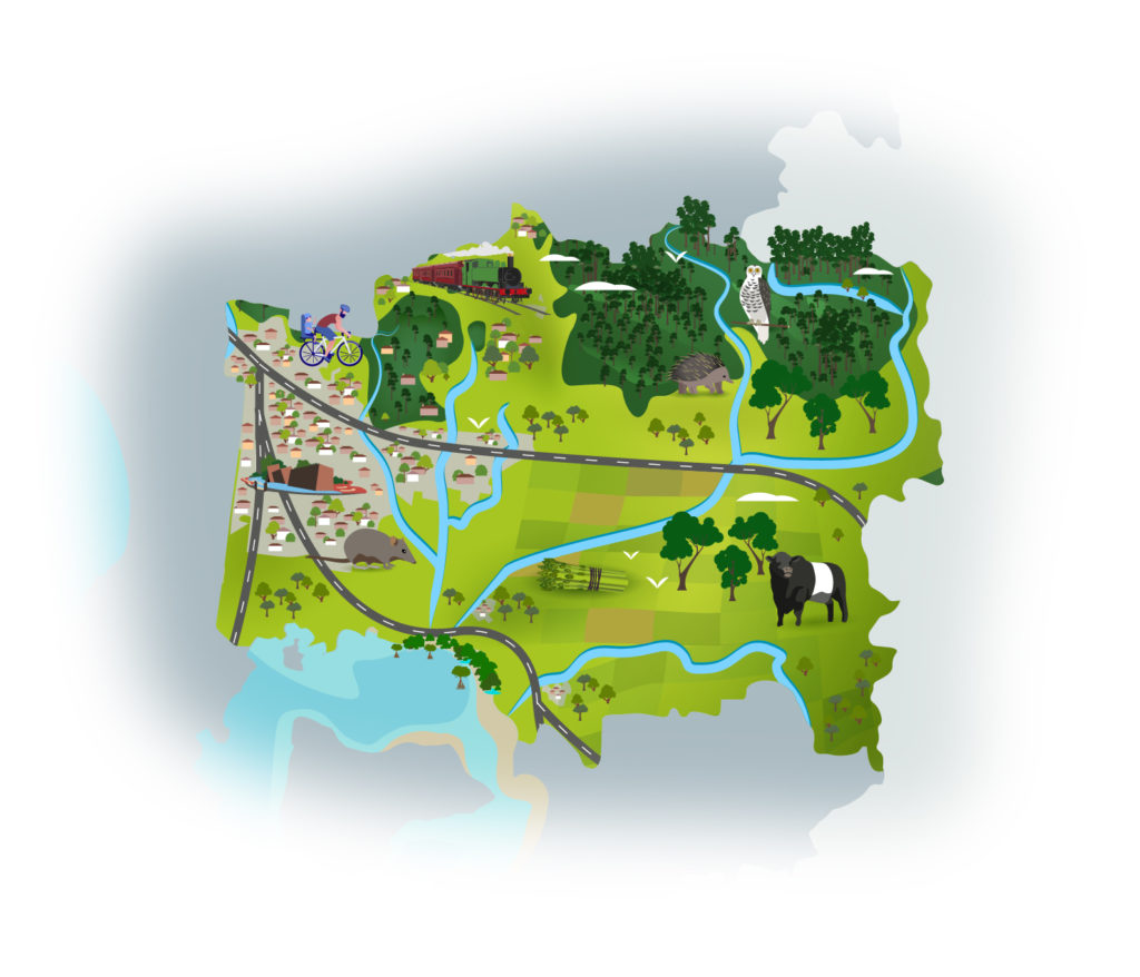
To the south is the former Koo Wee Rup Swamp which was drained to create 40,000 hectares of agricultural land. High-value, irrigated horticulture, grazing and nursery production occupy ‘the swamp’ from the southern edge of the growth corridors to the Western Port coast. This area is responsible for up to 85% of Australia’s asparagus production.
The area’s native flora and fauna includes the endangered Southern Brown Bandicoot, Powerful Owl, Little Galaxias and Strzelecki Gum.
Tourism is important in the region, aided by its proximity to and easy access from Melbourne. The area is known for its rural scenery and natural environment, as well as gourmet foods and wines.
The Casey, Cardinia and Baw Baw area is a major part of the Mornington Peninsula and Western Port Biosphere Reserve; one of four internationally-recognised, UNESCO Biosphere reserves in Victoria. The ‘Man and the Biosphere’ program’s goal for human activity to co-exist with nature is the crucial environmental challenge for the area’s communities and governments.
The condition of our environment now
Bunurong Country
The Casey, Cardinia & Baw Baw area is mostly Bunurong Country. The Bunurong Land Council Aboriginal Corporation is recognised as the Registered Aboriginal Party, primary guardians, keepers and knowledge-holders for Aboriginal cultural heritage and country in the area. They continue the modern movement by Traditional Owners to practice and strengthen their culture and care for Country.
Land use
The Casey-Cardinia area has experienced significant population growth over a prolonged period and will remain one of the fastest growing regions in Australia for decades to come, with up to 15,000 new residents moving into the area each year.
The Baw Baw region is a predominantly rural area, with rural-residential and urban areas in numerous smaller townships. The northern part of the region is heavily forested, while the southern part is used largely for dairy farming and agriculture.
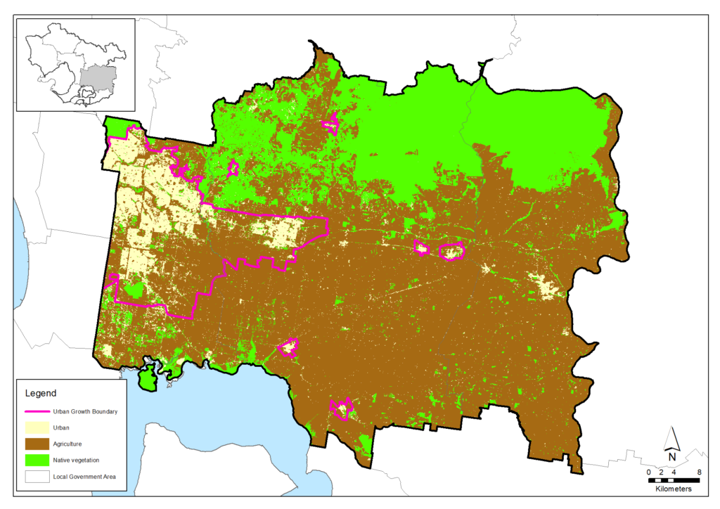
Approximately 28 per cent of the catchment retains its natural vegetation, 65 per cent is used for agriculture and 7 per cent is urban.
Agriculture
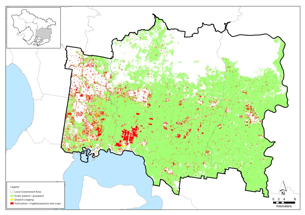
It is our region’s most productive agricultural area, with close to 1,750 farms and gross value of production of $681 million in 2015. Major industries include dairy, beef, poultry and vegetables.
More detail is available in the agriculture data table.
Groundwater is an important resource for agricultural industries in the area. Almost 4,000 megalitres were extracted and used in 2018-19 from the Koo Wee Rup Groundwater Management Unit, delivering an estimated value of almost $15 million per year. The groundwater resource is managed to ensure it is sustainable, with the annual extraction levels well below the permissible consumptive volume of 12,915 megalitres.
| Agriculture data from 2015-16 | Casey, Cardinia & Baw Baw area |
|---|---|
| Total area (Hectares) | 237,926 |
| Area of agriculture (Hectares) | 155,610 (65%) |
| Number of farms | 1,749 |
| Employment on farms | 4,787 |
| Gross value of annual agricultural production ($) | $681 million |
| Main agricultural commodities | Dairy, beef, poultry, vegetables, nurseries |
Agriculture in the Casey, Cardinia & Baw Baw area (derived from Victorian Land Cover Time Series data)
Soil health
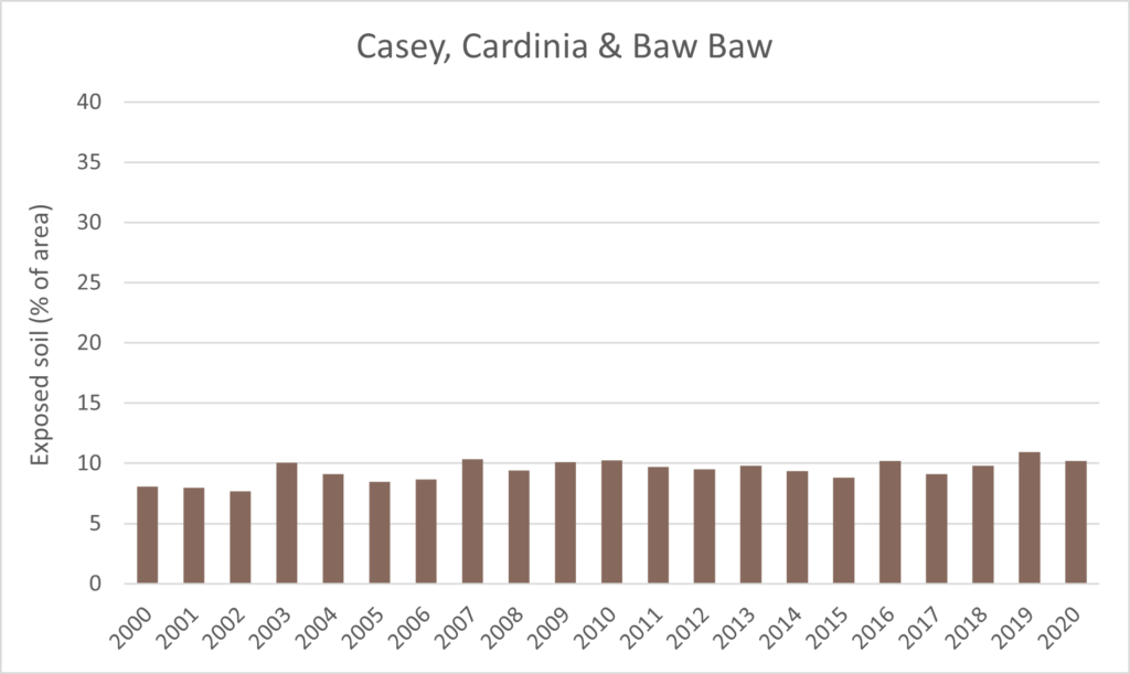
Over the whole area, the proportion of exposed soil has been below 10% for most years since 2000, as shown in the graph below, which indicates that most of the land remains covered and protected by vegetation (including pasture) at all times.
Proportion of exposed soils for the area from 2000 to 2020 (data from Australian National University)
Biodiversity
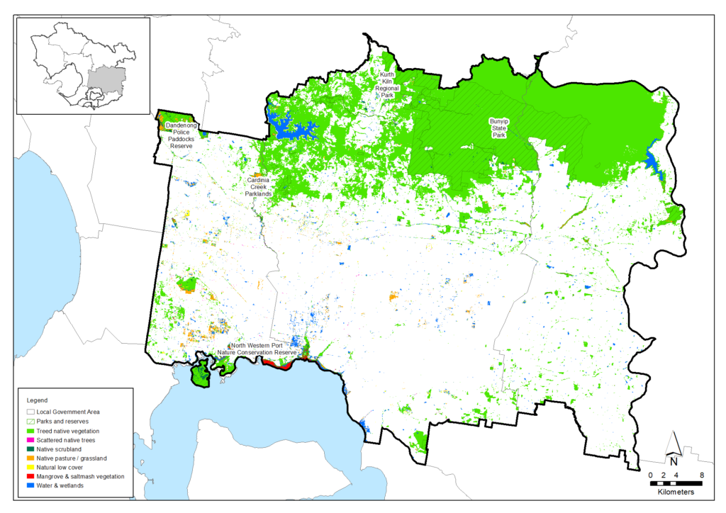
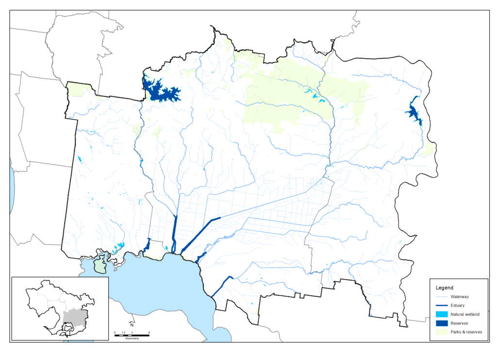
Native vegetation covers about 66,000 hectares or 28% of the Casey, Cardinia & Baw Baw area. This vegetation is concentrated in some landscapes while little remains across large parts of the area.
Native vegetation in the Cardinia Shire covers 29% of land area and 7% in the City of Casey. Tree canopy cover is estimated to cover only 14% of Cardinia’s private land. Little or no understory remains under two-thirds of private-land tree cover north of the Princes Highway. Bunyip State Park’s 11,000 hectares of heathland, forest, ranges and granite outcrops and the 2,000 hectares of coastal ribbon and islands of the North Western Port Nature Conservation Reserve are held by Parks Victoria. These are by far the largest and most intact conservation reserves in the Casey Cardinia Baw Baw area. The City of Casey, Cardinia Shire and Baw Baw Shire hold 97 nature reserves and near-natural open spaces totaling 1,100 hectares. They are valued patches of native vegetation but relatively small and scattered across an otherwise cleared landscape.
Native vegetation in the Casey, Cardinia & Baw Baw area (derived from Victorian Land Cover Time Series data)
Biodiversity Plans published by the City of Casey and Cardinia Shire contain varying estimates of the numbers of bird, mammal, fish, reptile and frog species found in their local government areas.
But both Council accounts are more optimistic than the loss of diversity of native animal species indicated in an analysis of animal sighting data that calculated the probability that each species of native fish, amphibians, reptiles, birds and mammals was persisting at the end of 2016.
The analysis indicated that more than two-thirds of the fish species, more than a third of the amphibian and reptile species, more than a quarter of the mammal species and around one-fifth of the bird species observed in the Casey, Cardinia & Baw Baw area since the 19th Century are now likely to be locally extinct.
| Native species | Number and proportion of species likely to be persisting (at 2016) |
|---|---|
| Birds | 236/291 (81%) |
| Mammals | 29/41 (71%) |
| Amphibians | 10/16 (63%) |
| Reptiles | 19/30 (63%) |
| Fish | 8/26 (31%) |
| Total | 302/404 (75%) |
Threatened species are considered to be priorities for local protection and recovery work. In many circumstances, work to protect and enhance their health and resilience will also benefit other native animal species and the local habitat. The following table shows some of the threatened species and ecological communities that have been recorded in this area. A full list of the threatened species known to occur in this region since 1980 is available at the Data tables section of this strategy.
Threatened species known to occur in the Casey, Cardinia & Baw Baw area
| Group | Species |
|---|---|
| Birds | Australasian Bittern, Australian Little Bittern, Barking Owl, Black Falcon, Blue-billed Duck, Caspian Tern, Curlew Sandpiper, Eastern Curlew, Eastern Great Egret, Freckled Duck, Grey Goshawk , Helmeted Honeyeater, Lewin's Rail, Little Egret, Little Tern, Masked Owl, Powerful Owl, Red Knot, Sooty Owl, Square-tailed Kite, White-bellied Sea-Eagle, White-throated Needletail |
| Mammals | Greater Glider, Grey-headed Flying-fox, Leadbeater's Possum, Southern Brown Bandicoot, Spot-tailed Quoll, Platypus |
| Reptiles | Swamp Skink, Lace Monitor |
| Amphibians | Growling Grass Frog, Southern Toadlet |
| Fish | Dwarf Galaxias, Australian Grayling |
| Invertebrates | Giant Gippsland Earthworm, Warragul Burrowing Crayfish |
| Flora | Clover Glycine, Frankton Spider-orchid, Green-striped Greenhood, Gully Grevillea, Large-fruit Yellow-gum, Maroon Leek-orchid, Matted Flax-lily, Round-leaf Pomaderris, Silver Gum, Strzelecki Gum, Swamp Everlasting, Tall Astelia, White Star-bush, Winter Sun-orchid, Yellow-lip Spider-orchid, Christmas Spider-orchid, Tall Astelia |
| Ecological communities | Natural Damp Grassland of the Victorian Coastal Plains, Seasonal Herbaceous Wetlands (Freshwater) of the Temperate Lowland Plains, Subtropical and Temperate Coastal Saltmarsh, White Box-Yellow Box-Blakely's Red Gum Grassy Woodland and Derived Native Grassland, Central Gippsland Plains Grassland, Cool Temperate Mixed Forest, Cool Temperate Rainforest, Forest Red Gum Grassy Woodland, Herb-rich Plains Grassy Wetland (West Gippsland), Limestone Grassy Woodland, South Gippsland Plains Grassland |
Water and waterways
Tarago Reservoir impounds surface water from the Tarago River and its tributaries. It supplies potable water to Westernport and Mornington Peninsula communities. About three-quarters of the Tarago catchment is in Bunyip State Park where water quality is vulnerable to camping and track erosion from 4WD and trailbikes. Melbourne Water, Baw Baw Shire Council and the Neerim District Landcare Group are pursuing an ongoing project to improve the quality of inflows to the reservoir from private land.
Cardinia Reservoir is a major water storage for metropolitan Melbourne. It is not connected to local streams but holds water transferred from the Silvan Reservoir and the Wonthaggi Desalination Plant.
Rivers and creeks are in mostly moderate to good condition near their sources in the northern hill country of the Casey, Cardinia & Baw Baw area. But the lower reaches of the Clyde, Cardinia, Gum Scrub, Toomuc and Deep Creeks and the Bunyip and Lang Lang Rivers were turned into straight, channelised drains by the 1930s in massive schemes to drain the Koo Wee Rup, Dalmore and Tobin Yallock Swamps. This created 40,000 hectares of valued farmland but forever changed Victoria’s largest wetland and transported vast quantities of eroded drain mud into Western Port’s intertidal and marine environments.
The past century of ecological disruption has now stabilised. The new challenge is to manage the environmental impacts of this century’s urbanisation of the Casey-Cardinia Growth Corridors.
The Healthy Waterways Strategy 2018-28 assessment of rivers and creeks in the Western Port and Mornington Peninsula region is summarised below.
| Waterway values | 2018 state | 2018 trajectory | 2068 target |
|---|---|---|---|
| Birds | Moderate | Moderate | Moderate |
| Fish | Low | High | High |
| Frogs | High | Moderate | High |
| Macroinvertebrates | Moderate | Low | High |
| Platypus | Moderate | Low | Moderate |
| Vegetation | Low | Very low | Moderate |
| Amenity | High | Moderate | Very high |
| Community connection | High | Moderate | High |
| Recreation | High | High | High |
| Waterway conditions | 2018 state | 2018 trajectory | 2068 target |
|---|---|---|---|
| Stormwater | High | Moderate | High |
| Physical form | Moderate | Low | Moderate |
| Water for the environment | High | Moderate | High |
| Vegetation quality | Low | Very low | Moderate |
| Vegetation extent | Low | Low | High |
| Instream connectivity | Moderate | Moderate | High |
| Water quality - environment | Low | Very low | Low |
| Access | Very low | Very low | Low |
| Litter | High | Moderate | Very high |
| Water quality - recreational | High | Moderate | High |
| Participation | Moderate | Low | Very high |
Coast
The coast of northern Western Port forms the southern boundary of the Casey Cardinia Baw Baw area. The western half of the coast is well-vegetated with mangroves, saltmarsh and melaleuca. This is protected in the sheltered inlets and estuaries and islets of the North Western Port Nature Conservation Reserve. The more-exposed 25 km of coast east of the Bunyip River estuary consists of bare and retreating cliffs of black clay backed by saltmarsh. Mangrove loss on this coast is a major source of degraded water quality in Western Port. Unhindered wave action is eroding the unprotected cliffs and threatening adjacent farmland. The vast mudflats this has created are too unstable to support mangroves or seagrass and each high tide remobilises the mud in the water. The aquatic habitats are home to a range of species, including those listed under the Environment Protection and Biodiversity Conservation Act (EPBC) such as the Little Galaxias and Australian Grayling.
Community action
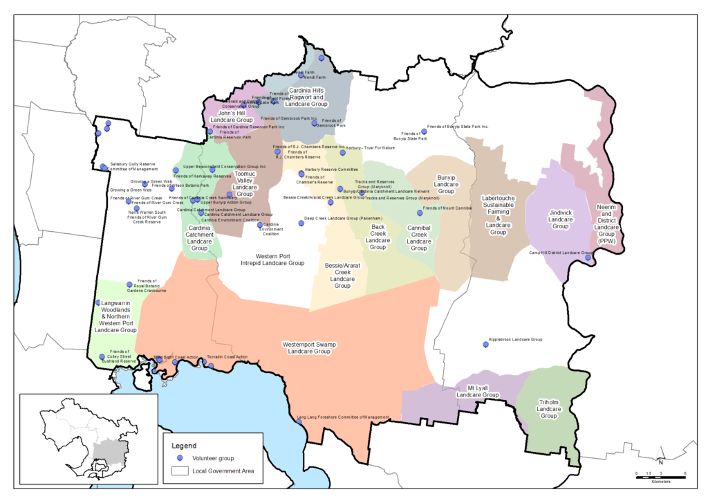
There is a vibrant Landcare movement amongst the farmers and landholders in the Casey, Cardinia & Baw Baw area. There are 19 active Landcare Groups, many of which come together as members of the Westernport Catchment Landcare Network. Based on data from a 2019 survey, it is estimated that the groups and networks collectively have around 906 members and volunteer around 28,944 hours per year for Landcare activities that benefit the environment, landscapes and community. This volunteering is worth in the order of $975,702 per year.
Community volunteers are also active in numerous Friends groups, Committees of Management and other volunteer organisations across the sub-region. There are an estimated 42 organisations providing 7,159 volunteer hours worth $241,330 per year.
More detail is available in the Community volunteering data table.
Challenges we face
Climate change, population pressures and urbanisation are major challenges to the future health of environments in the Casey, Cardinia & Baw Baw area.
Climate change
The Climate Change in the Port Phillip & Western Port Region report identifies risks and responses to warmer, drier conditions and rising sea levels across the region. The report says climate change will particularly affect the following environmental assets in the Casey, Cardinia, & Baw Baw area:
- large areas of native vegetation between Beaconsfield and Drouin, including the Bunyip State Park and north and south of Drouin
- coastal vegetation between Quail Island and Tooradin
- Cardinia Creek in the Beaconsfield area
- coastal wetlands across northern Western Port from Yaringa to Yallock Creek
- soils between Narre Warren and Pakenham.
Climate Risk Assessments developed by Local Government-based Alliances for Greenhouse Action around Melbourne and work by the South East Councils Climate Change Alliance indicate:
- Vulnerability to climate change is compounded for newly arrived migrants, the aged and young children and people living in relative poverty, in sub-standard housing or with poor English
- Lack of understanding of local flora and fauna species responses to climate change is hampering timely and effective investment and action for biodiversity conservation
- Social and policy pressures for larger fire breaks and more fuel-reduction burning is impacting biodiversity and air quality
- Changing wildfire frequency and intensity in warmer, drier conditions is damaging biodiversity and increasing demands for fire-management effort
- Fire agency management planning often conflicts with the environmental protection goals and targets of local, regional and state environment strategies.
Urbanisation and population growth
Population forecasts for the City of Casey, Cardinia Shire and the part of Baw Baw Shire in the Western Port Catchment chart total growth of 67% over the next 20 years – from 527,000 in 2021 to 780,000 in 2041. The urbanisation effect of this growth is forecast to expand the number of dwellings by 52% – from 145,300 in 2021 to 275,000 in 2041.
Urban development brings:
- demands for space, facilities, transport infrastructure and access to recreation areas
- damage from illegal clearing, vehicle tracks, vandalism, feral animals, firewood collection and rubbish dumping
- altered stream flows and water pollution from increased hard-surface run-off
- waterways habitats damaged by flood protection works and sediment inputs
- barriers to animal movement created by roads and infrastructure
- continuing habitat damage from recreation, vandalism, informal vehicle tracks and rubbish
- continued clearing for buildings, fences, access, views etc.
- feral domestic animals
- pest plants and plant diseases such as Phytophthora cinnamoni spread by humans, birds and animals and from dumped garden waste
Melbourne’s third major airport is proposed by private consortiums for one of two sites between Koo Wee Rup and Lang Lang. Extensive new areas of impervious surface, flight paths over Western Port’s Ramsar wetlands, transport and freight handling infrastructure, new and upgraded roads will add to planned urbanisation impacts.
Native vegetation loss across the Casey, Cardinia, Baw Baw area is likely to continue species decline. The 2004 biodiversity study, How much habitat is enough? showed that landscapes with less than 15% vegetation cover may support diverse but low populations of native plant and animal species, but their future is not assured. The study recommends that increasing vegetation cover above 15% could be an intermediate revegetation goal while 35% cover should be a goal where practicable.
This is partly consistent with the City of Casey Biodiversity Strategy goal to increase tree retention, canopy cover and connectivity and the Cardinia Biodiversity Conservation Strategy goal to develop a bio-links plan and plant 226,000 indigenous plants on public and private land by 2029.
New conservation reserves are proposed by the SE Growth Corridor Plan for public land on the Cranbourne-Clyde-Tooradin railway reserve and on the Cardinia and Clyde Creeks. But measures to improve habitat connectivity for Southern Brown Bandicoots on private land around the Cranbourne Botanic Gardens were not supported ahead of maximising development densities.
This barrier to nature conservation policy and strategy on the edge of a growing city is discussed in the City of Casey Biodiversity Strategy:
- population growth creates pressures for development to occur at the expense of biodiversity
- biodiversity is not a priority or incompatible with competing (planning) goals, priorities, time and commitments
- many residents in Casey’s multicultural communities have little connection, awareness or appreciation of Casey’s natural environments.
Weeds and pest animals
Pest plants and environmental weeds are a major threat to the area’s natural environment. Once established, they grow vigorously because they have few natural predators or diseases to control them. They change and destroy habitats and ecosystems, outcompeting indigenous plants for light, nutrients and water. This leaves our wildlife without food and habitat, leading to the decline of our native animals. Many pest plants are spread from domestic gardens. Seeds are spread by birds and animals or by people dumping garden cuttings into our bush and waterways. Coastal weeds such as Sea spurge invade the nesting habitats of shorebirds and seabirds.
Pest animals significantly impact on native plants and animals and their habitats. Foxes and cats, in particular, are exceptional hunters and are the primary cause of the decline and extinction of many smaller native animals. Other pest animals including rabbits directly compete with native wildlife for food and shelter, damage native vegetation and degrade the land, while introduced fish species compete for food and prey on native fish, tadpoles and frogs.
Supporting Bunurong connection to Country
There is a challenge to strengthen the role and influence of traditional ecological knowledge and practices in today’s natural resource management programs, where that is allowed and offered by Traditional Owners.
There are currently relatively few Aboriginal people who have jobs taking care of Country in this region. There is a challenge in providing timely, tailored support for Registered Aboriginal Parties and other Aboriginal organisations so they can determine their aspirations and build their workforce to suit their aims with the appropriate range of skills.
Traditional Owners’ rights to water have largely been excluded from water planning and management policies and programs. Without water rights, Traditional Owners are unable to decide where or how water can be used to support cultural, spiritual, environmental or economic outcomes. There is an opportunity to address this in water planning and by securing bulk water allocations for Registered Aboriginal Parties to enable cultural watering.
Policy and planning
A range of policies and plans are in place to protect and enhance the area’s cultural, social, environmental and economic values and address the challenges that lie ahead.
Plan Melbourne 2017-2050 is the main integrated land-use, infrastructure and transport plan published by the Victorian Government. It aims to support economic growth and protect liveability and sustainability across metropolitan Melbourne. As part of its implementation, Land Use Framework Plans are being developed to guide strategic land-use and infrastructure development for the next 30 years in six metropolitan Melbourne regions. This includes the Southern region (comprising Cardinia, Casey, Frankston, Greater Dandenong, Kingston and Mornington Peninsula Local Government Areas).
For Melbourne’s urban growth areas, the Victorian Planning Authority manages the development of Precinct Structure Plans (PSPs) which are master plans for local areas that usually cater for between 5,000 to 30,000 people, 2,000 to 10,000 jobs or a combination of both. PSPs provide more specific detail regarding how existing important features of local communities such as roads, shopping centres, schools, parks, key transport connections and areas for housing and employment may evolve or transform over time and become better integrated.
The management of land, water and biodiversity in the Casey, Cardinia & Baw Baw area is principally overseen by its three councils, Melbourne Water, Parks Victoria, the Department of Energy, Environment and Climate Action and EPA Victoria along with landholders and other authorities, organisations and community groups. The area’s most significant strategies and plans include the:
- City of Casey Biodiversity Strategy 2018
- Shire of Cardinia Biodiversity Conservation Strategy 2019-2029
- Shire of Baw Baw Environmental Sustainability Strategy 2018-2022
- Healthy Waterways Strategy 2018-28 which provides vision statements, goals and 10 and 50-year targets for waterway management in each of the region’s catchments
- Protecting Victoria’s Environment – Biodiversity 2037 – the Victorian Government’s state-wide strategy to arrest biodiversity decline
- The Eastern Region Pest Animal Strategy 2020-2030 developed by the Eastern Region Pest Animal Network
- Southern Rural Water’s Koo Wee Rup Groundwater Management Plan and Local water reports that include recent information on metered groundwater extraction, groundwater trends and emerging local groundwater issues.
An Asset Vulnerability Assessment and a Community Climate Change Action Plan are being developed by the South East Councils Climate Change Alliance.
Traditional Owners are the voice of their Country
For all policy and planning, there is a need for recognition and inclusion of Traditional Owner knowledge and aspirations. The waterways and lands are increasingly being recognised as ‘living and integrated natural entities‘ and the Traditional Owners should be recognised as the ‘voice of these living entities’. A Country Plan being prepared by the Bunurong Land Council Aboriginal Corporation will describe the vision and priorities of the Traditional Owners for Country in line with their role as a Registered Aboriginal Party, and provide a strong basis for all planning to recognise and include the voice of these Traditional Owners.
Vision and targets for the future
Vision
The Traditional Owners of this area, the Bunurong people, have cared for this Country for tens of thousands of years. A vision for its future will be outlined in the Bunurong Country Plan (in preparation)
Local councils in the area are committed to protecting and enhancing the catchment’s rich biodiversity. Council visions for biodiversity are:
City of Casey
To protect, conserve and enhance our biodiverse environment recognising its fundamental importance to achieving a healthy environment and way of life for current and future generations
Cardinia Shire Council
Cardinia Shire’s natural environment is protected, valued and enhanced in partnership with the community to improve our quality of life
Baw Baw Shire Council
Protecting and sustainably managing Baw Baw’s environment and preparing for the impacts and consequences of climate change
The City of Casey Biodiversity Strategy 2018 includes directions to:
- protect biodiversity through appropriate enforcement
- manage Council’s nature reserves for their biodiversity values
- advocate for the protection, enhancement and conservation of biodiversity across Casey
- encourage land owners and managers to adopt innovative conservation approaches
- protect remnant vegetation and biodiversity habitats in Casey
- advance revegetation on public and private land
- enhance and promote habitat connectivity across Casey
- provide and strengthen opportunities for the community to connect with and enjoy nature.
The Cardinia Shire Council Biodiversity Conservation Strategy’s includes four goals to:
- achieve a net gain of the overall extent and condition of habitat across land and waterway environments
- improve the quantity and quality of indigenous flora and fauna on private and public land
- map bio-link corridors that will enhance biodiversity connectivity across the region
- increase community participation, engagement and education in natural environment programs.
The Baw Baw Shire Council Environmental Sustainability Strategy 2018-2022 includes commitments to:
- continue to build partnerships and provide support to local environmental community groups and individuals
- provide support and encourage volunteers working in bushland and public open space reserves
- provide information and products to promote community interaction with natural areas.
- implement bushland reserve management plan actions relating to environmental management, biodiversity conservation and biosecurity
- continue to consult and work closely with indigenous populations in relation to environmental management and signage within our bushland and public open space reserves
- align Council’s ongoing activities involving revegetation and restoration of waterways and public open space reserves with a bio-link corridor focus.
Regional Catchment Strategy targets
The following targets for the area, at the year 2050 or later, reflect the region-scale vision of the Regional Catchment Strategy and the visions and directions of the local councils, the Healthy Waterways Strategy, other plans and the community. They will contribute to achieving these visons and objectives and help ensure this area remains healthy and prosperous for future generations. The targets are the local contributions towards achieving regional-scale targets outlined in the ‘Themes‘ section of this strategy.
Partner organisations for the journey ahead
The following organisations formally support the pursuit of the Regional Catchment Strategy’s targets for the Casey, Cardinia & Baw Baw area. They have agreed to provide leadership and support to help achieve optimum results with their available resources, in ways such as:
- Fostering partnerships and sharing knowledge, experiences and information with other organisations and the community
- Seeking and securing resources for the area and undertaking work that will contribute to achieving the visions and targets
- Assisting with monitoring and reporting on the condition of the area.
Traditional Owners
- Bunurong Land Council Aboriginal Corporation
Local Government
- City of Casey
- Baw Baw Shire Council
- Eastern Region Pest Animal Network
- Cardinia Shire Council
- South East Councils Climate Change Alliance
Community
- Southern Ranges Environment Alliance
- Cardinia Environment Coalition
- Western Port Catchment Landcare Network
- Westernport Swamp Landcare Group
- French Island Landcare Group
Victorian Government
- Melbourne Water
- Parks Victoria
- Environment Protection Authority Victoria (EPA)
- Trust for Nature
- Victorian Fisheries Authority
- Victorian Planning Authority
- South East Water
- South Gippsland Water
- Sustainability Victoria
- Victorian Environmental Water Holder
- Zoos Victoria
Non Government
- Western Port Biosphere Reserve Foundation
- GippsDairy
- Dolphin Research Institute
- The Nature Conservancy
- Birdlife Australia
- Western Port Seagrass Partnership
- Habitat Restoration Fund
- Gardens for Wildlife Victoria
- Conservation Volunteers Australia
- Native Fish Australia (Vic)
- OzFish Unlimited
- The People and Parks Foundation
- Field Naturalists Club of Victoria
Add your organisation as a supporter and partner
If your organisation supports these directions and targets for Casey, Cardinia & Baw Baw, you can request to be listed as a partner organisation. Adding your organisation to this list will:
- Enable your organisation to list one or more priority projects in the Prospectus which will describe how your priority project will pursue the targets of this Regional Catchment Strategy and potentially make your organisation’s project more attractive to investors by using the strategy to highlight its relevance and value
- Demonstrate your commitment to a healthy and sustainable environment
- Demonstrate the level of community engagement and support for this work.
Priority projects to move forward
Priority projects
There are significant ongoing programs and initiatives undertaken by many organisations that are vital for the management of natural resources and the support of communities in the Casey, Cardina & Baw Baw area. In addition, there are numerous project proposals that, if funded and implemented, can contribute to achieving the Regional Catchment Strategy’s visions and targets for the area. They include projects that:
- Establish new vegetation in large-scale, strategic locations where it provides multiple benefits by contributing to carbon sequestration, habitat restoration and habitat connectivity
- Help achieve net gain in the extent and condition of habitat across public and private land, coasts and waterways
- Protect waterways
- Protect threatened species
- Support soil health and the adoption of sustainable agriculture practices
- Support resilience to climate change in agricultural enterprises and communities
- Protect ‘blue carbon’ stores held in coastal/marine soils and vegetation including saltmarsh, mangrove and seagrass
- Allow mangroves and saltmarsh to retreat along the Western Port coast as the sea level rises
- Increase community participation, engagement, education and enjoyment in nature and conservation
- Strengthen Traditional Owners roles in environmental decision-making and action.
Potential projects include:
- Healesville to Phillip Island Nature Link led by HPNL Inc.
- Cardinia Creek catchment enhancement proposed by the Southern Ranges Environment Alliance
- Farmers digging deeper proposed by the Western Port Catchment Landcare Network
- Cannibal Creek Catchment Biodiversity Project proposed by the Western Port Catchment Landcare Network
- Tarago Catchment Project proposed by the Western Port Catchment Landcare Network
- Hydrological study to investigate and enhance groundwater management in the Westernport basin proposed by Southern Rural Water
- Integrated Pest Management in pastures proposed by Melbourne Water
- Bandicoots in our Backyards proposed by Melbourne Water
- City of Casey Ramsar Protection Program led by the City of Casey
- North Western Port Nature Conservation Reserve Terrestrial Herbivore Management proposed by Parks Victoria
- North Western Port Nature Conservation Reserve Weed Control proposed by Parks Victoria
- North Western Port Nature Conservation Reserve Introduced Predator Management proposed by Parks Victoria
- Quail Island and Chinaman Island Introduced Predator Management proposed by Parks Victoria.
A list of project proposals and their key details can be viewed and sorted on the Prospectus section of this website.
Propose a new priority project
As part of the ongoing development and refinement of this Regional Catchment Strategy, additional priority projects may be considered for inclusion in the Prospectus.
If your organisation supports the directions and targets for this area, and has a project it would like highlighted and supported in this Regional Catchment Strategy, please submit a Prospectus Project Proposal.

