A special place to live, work and visit
For tens of thousands of years, the Mornington Peninsula has been part of Bunurong Country. Bunurong people lived and moved throughout the area using the abundant resources that the land and waters provided.
Today, Bunurong people continue to live, practice and strengthen their culture on the Mornington Peninsula though much has changed from the past.
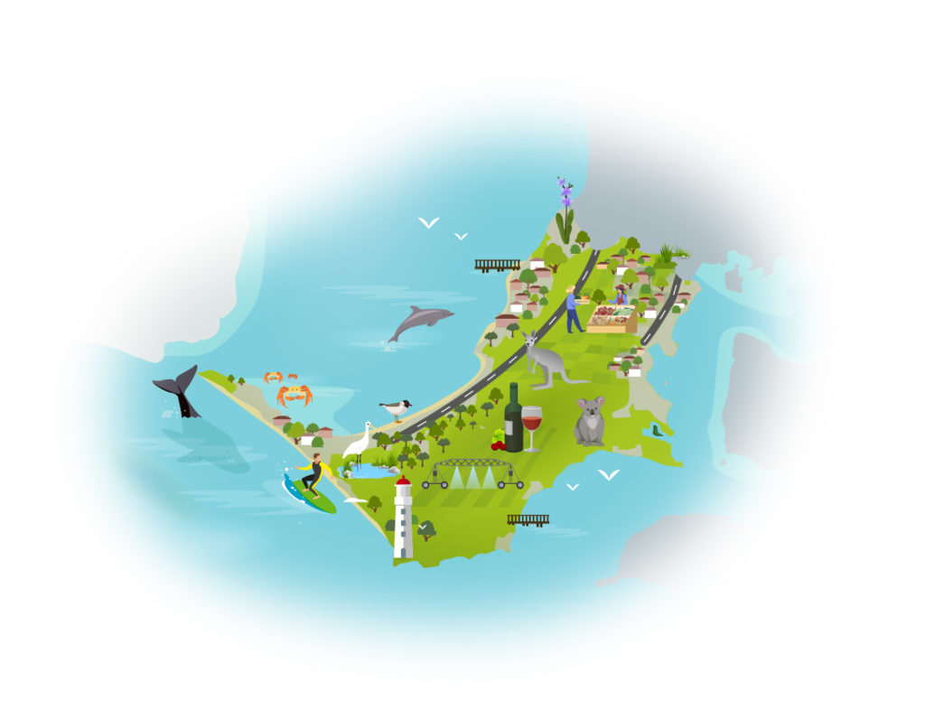
The Mornington Peninsula is now a famous area and one of the most visited and popular recreational areas in Victoria. Tourists and day visitors from Melbourne flock here due to its scenic landscapes and beaches, biodiversity, sites of cultural heritage and historic importance and productive rural land.
The Peninsula’s landscape supports a healthy and diverse tourism and recreation economy, built around its stunning coastal and rural backdrop and the opportunity for people to reconnect with nature. The beaches and foreshores in the south are among Melbourne’s busiest during the summer months, popular for camping, walking, swimming, fishing and boating. Inland, the many vineyards, restaurants and farm-gate activities are popular attractions, as are the many world-class golf courses in the area.
Virtually all of the towns on the Peninsula have a rural landscape backdrop and no site is more than a 10 minute drive from a major reserve, area of bushland or the coast.
As Victoria’s population grows, the Mornington Peninsula will continue to play a major role in the liveability, sustainability and prosperity of metropolitan Melbourne and surrounds.
The condition of our environment now
The Mornington Peninsula has been Bunurong Country for more than 40,000 years. The Bunurong Land Council Aboriginal Corporation is the Registered Aboriginal Party for the whole of the Mornington Peninsula and there is increasing recognition, respect and support for Bunurong people to protect, reintroduce and strengthen their cultural heritage.
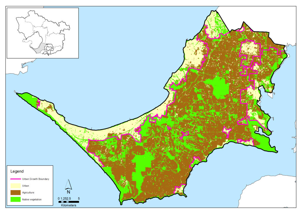
Today, approximately 83% of the Mornington Peninsula is rural (mainly farmland or native vegetation) and approximately 17% is urban. This retention of a high proportion of ‘green space’ has been a foundation for maintaining the Peninsula’s social, environmental and economic values, and has been strongly planned for, monitored and defended by the Mornington Peninsula Shire Council in policy and planning mechanisms including ensuring 70% of the Peninsula is defined as one of Melbourne’s ‘Green Wedges’ outside of the Urban Growth Boundary.
Broad land use on the Mornington Peninsula (derived from Victorian Land Cover Time Series data)
Agriculture
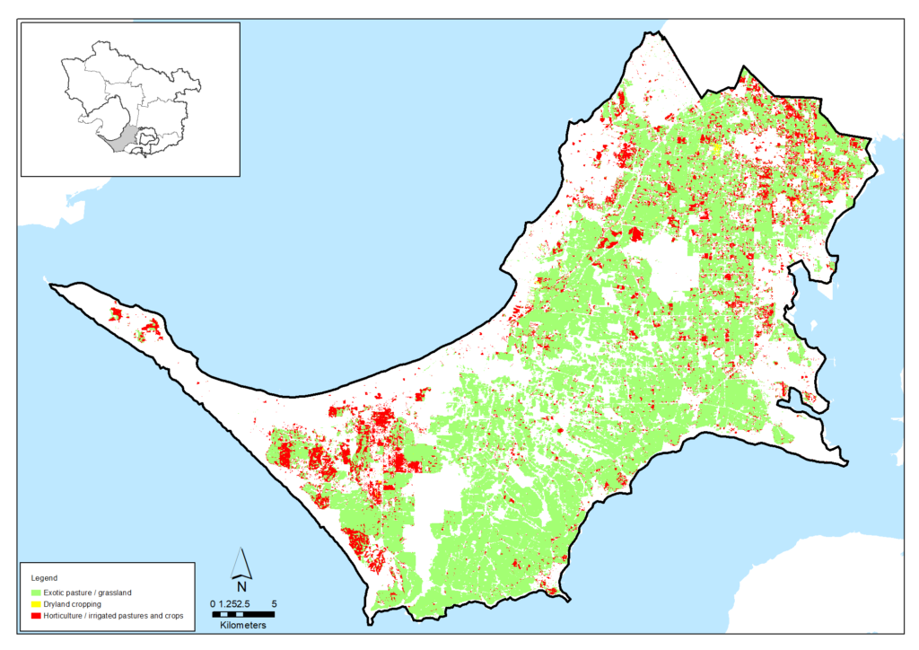
The gross value of agricultural production on the Peninsula in 2015-16 was $199 million with the main industries including poultry, horticultural (fruit, vegetable, wine grapes, salad mix) and livestock. More detail is available in the agriculture data table.
Various artisan and value-added businesses continue to emerge alongside established farming enterprises.
Groundwater is an important resource for agricultural industries in the south of the Peninsula. Almost 3,000 megalitres were extracted and used in 2018-19 from the Nepean Groundwater Management Unit and provides estimated value of at least $12 million per year. The groundwater resource is managed to ensure it is sustainable, with the annual extraction levels well below the permissible consumptive volume of 6,110 megalitres.
| Agriculture data from 2015-16 | Mornington Peninsula |
|---|---|
| Area of Mornington Peninsula (Hectares) | 72,004 |
| Area of agriculture (Hectares) | 38,864 (54%) |
| Number of farms | 422 |
| Employment on farms | 1,922 |
| Gross value of annual agricultural production ($) | $199 million |
| Main agricultural commodities | Poultry, fruits and nuts, vegetables |
Agriculture on the Mornington Peninsula (derived from Victorian Land Cover Time Series data)
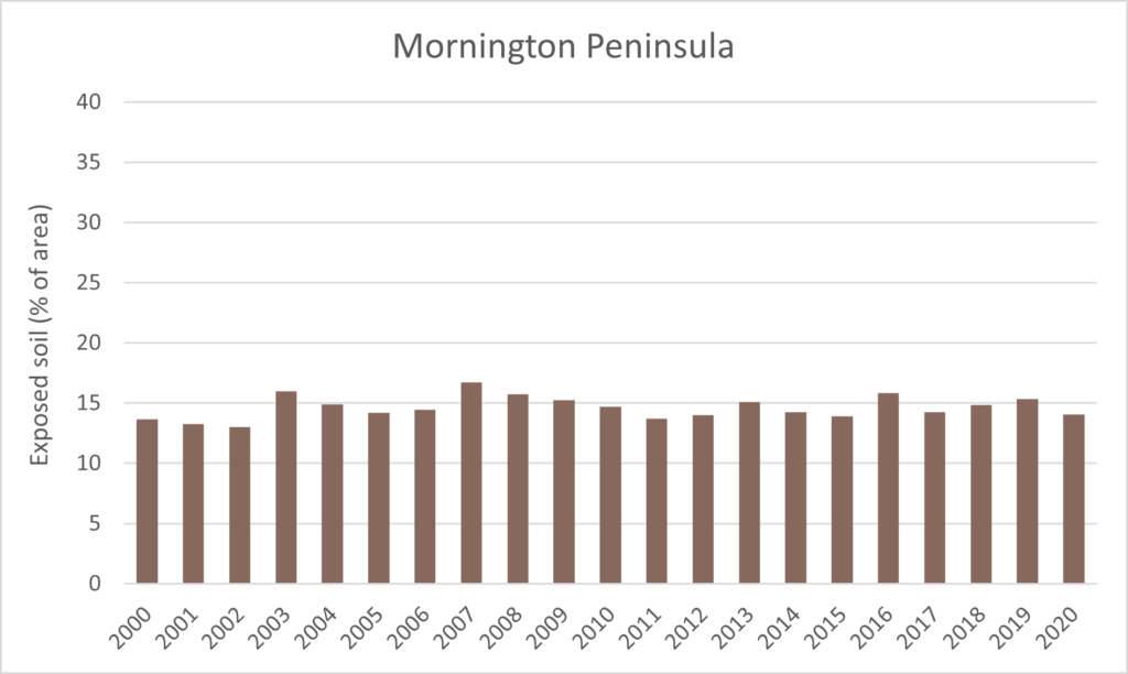
With rainfall averaging around 739 mm/year, supplemented with irrigation using groundwater, the Peninsula generally has high levels of vegetation cover on its soil. Over the whole area, the proportion of exposed soil has been below 15% for most years since 2000, as shown in the graph below, which indicates that most of the land remains covered and protected by vegetation (including pasture) at all times. This tends to protect the Peninsula from the threat of widespread wind erosion of its soil.
Proportion of exposed soils for the area from 2000 to 2020 (data from Australian National University)
Biodiversity
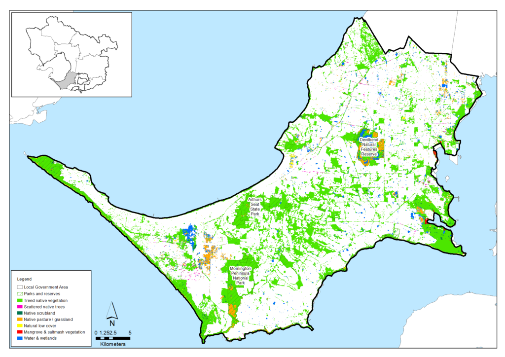
The Mornington Peninsula’s natural environment has undergone significant modification since European settlement, including extensive habitat fragmentation, incremental degradation of ecosystems and subsequent declines and extinction of species. Only an estimated 29% of the original extent of native vegetation remains, much of which is in important native vegetation reserves including the Mornington Peninsula National Park, the Arthurs Seat State Park and Green’s Bush.
Work is under way to extend and better connect the native vegetation across the Peninsula, including to establish biolinks between major vegetation reserves in the future.
Native vegetation on the Mornington Peninsula (derived from Victorian Land Cover Time Series data)
The Mornington Peninsula Shire Council’s Biodiversity Conservation Plan says 402 native vertebrate fauna species have been recorded in the area including 36 mammal, 301 bird, 25 reptile, 11 amphibian and 29 fish species. Ten species are now considered to be locally extinct, most of which are bird species, and 81 species are threatened nationally or in Victoria (primarily bird and mammal species). Those species which have suffered the greatest declines are ground-dwelling grassland and woodland birds and small mammals.
A similar picture is painted in an analysis of animal sighting data that calculated the probability that each species of native fish, amphibians, reptiles, birds and mammals recorded in the area was persisting at the end of 2016.
The analysis indicated that, for the Mornington Peninsula, perhaps only 71% of the total number of species recorded here are still persisting. In general, amphibians and birds seem to have fared the best whereas native fish species seem to been significantly reduced.
| Native species | Number and proportion of species likely to be persisting (at 2016) |
|---|---|
| Birds | 225/295 (76%) |
| Mammals | 17/33 (52%) |
| Amphibians | 11/13 (85%) |
| Reptiles | 16/26 (62%) |
| Fish | 5/18 (28%) |
| Total | 274/385 (71%) |
Threatened species are considered to be priorities for local protection and recovery work. In many circumstances, work to protect and enhance their health and resilience will also benefit other native animal species and the local habitat. The following table shows some of the threatened species and ecological communities that have been recorded in this area. A full list of the threatened species known to occur in this region since 1980 is available at the Data tables section of this strategy.
Threatened species known to occur on the Mornington Peninsula
| Group | Species |
|---|---|
| Birds | Australasian Bittern, Barking Owl, Black Falcon, Blue-billed Duck, Caspian Tern, Curlew Sandpiper, Eastern Curlew, Eastern Great Egret, Fairy Tern, Freckled Duck, Grey Goshawk, Hooded Plover, Lewin's Rail, Light-mantled Sooty Albatross, Little Egret, Northern Giant Petrel, Plumed Egret, Powerful Owl, Southern Giant petrel, Square-tailed Kite, Swift Parrot, White-bellied, Sea-Eagle, White-throated Needletail |
| Mammals | Grey-headed Flying-fox, Southern Brown Bandicoot, White-footed Dunnart, Platypus |
| Reptiles | Swamp Skink, Lace Monitor |
| Amphibians | Growling Grass Frog, Southern Toadlet |
| Fish | Dwarf Galaxias |
| Flora | Clover Glycine, Coast Helmet-orchid, Dense Leek-orchid, Frankton Spider-orchid, Late Helmet-orchid, Leafy Greenhood, Mount Martha Bundy, Purple Eyebright |
| Ecological Communities | Natural Damp Grassland of the Victorian Coastal Plains, Seasonal Herbaceous Wetlands (Freshwater) of the Temperate Lowland Plains, Subtropical and Temperate Coastal Saltmarsh, Central Gippsland Plains Grassland, Coastal Moonah Woodland, Herb-rich Plains Grassy Wetland (West Gippsland), South Gippsland Plains Grassland |
Waterways
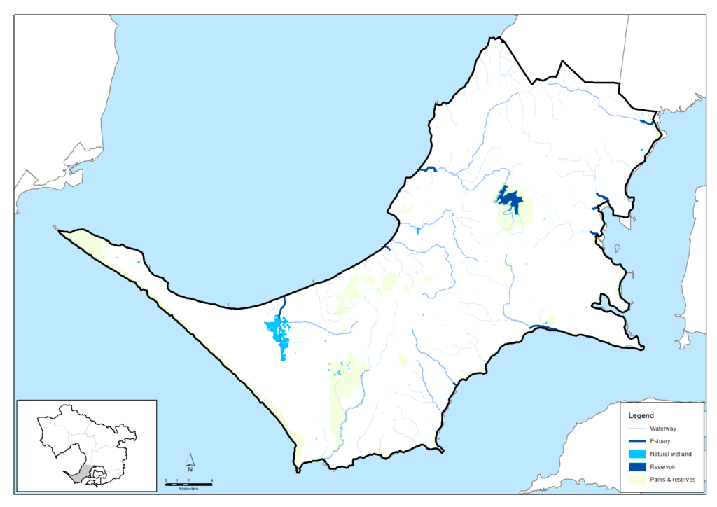
The Mornington Peninsula region is contained within the Westernport and Mornington Peninsula major catchment and includes the main river and creek systems of the Drum Drum Alloc Creek, Main Creek, Stony Creek, Warringine Creek and Balcombe Creek. It is home to significant wetland habitats, including the internationally significant Western Port Ramsar site, Tootgarook Swamp and Balcombe Estuary. It has 190 kilometres of coastline which is 10% of Victoria’s total, and is part of the Mornington Peninsula and Western Port Biosphere Reserve which is one of four internationally-recognised biosphere reserves in Victoria.
Rivers and wetland conditions and conservation strategy for the area are described in the Westernport and Mornington Peninsula chapters of the Healthy Waterways Strategy. Waterways generally have a low to high rating across a range of key environmental values and waterway conditions.
The Healthy Waterways Strategy 2018-28 assessment of rivers and creeks in the Western Port and Mornington Peninsula region is summarised below.
| Waterway values | 2018 state | 2018 trajectory | 2068 target |
|---|---|---|---|
| Birds | Moderate | Moderate | Moderate |
| Fish | Low | High | High |
| Frogs | High | Moderate | High |
| Macroinvertebrates | Moderate | Low | High |
| Platypus | Moderate | Low | Moderate |
| Vegetation | Low | Very low | Moderate |
| Amenity | High | Moderate | Very high |
| Community connection | High | Moderate | High |
| Recreation | High | High | High |
| Waterway conditions | 2018 state | 2018 trajectory | 2068 target |
|---|---|---|---|
| Stormwater | High | Moderate | High |
| Physical form | Moderate | Low | Moderate |
| Water for the environment | High | Moderate | High |
| Vegetation quality | Low | Very low | Moderate |
| Vegetation extent | Low | Low | High |
| Instream connectivity | Moderate | Moderate | High |
| Water quality - environment | Low | Very low | Low |
| Access | Very low | Very low | Low |
| Litter | High | Moderate | Very high |
| Water quality - recreational | High | Moderate | High |
| Participation | Moderate | Low | Very high |
Community action
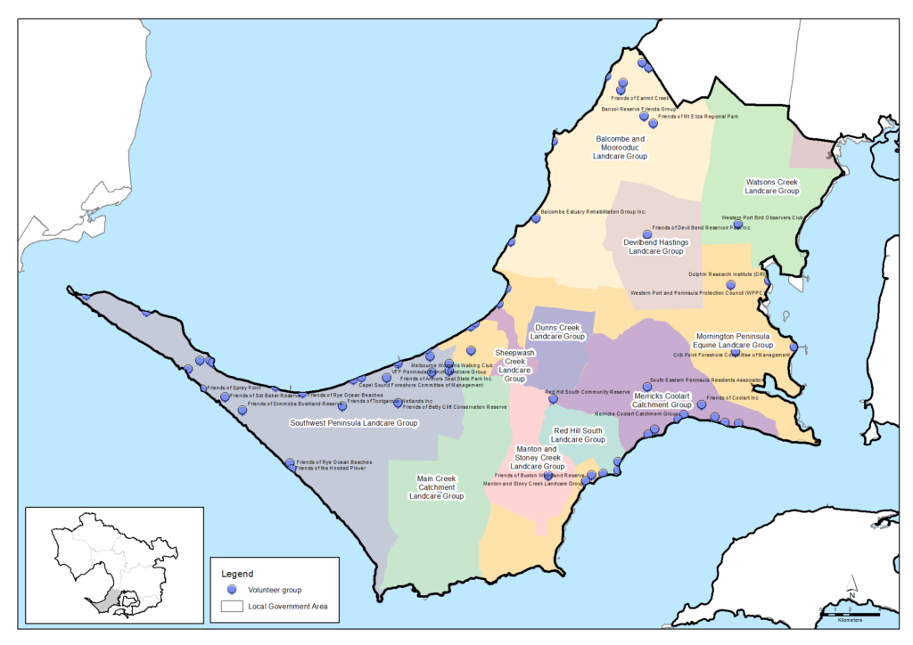
There is a vibrant Landcare movement amongst the farmers and landholders on the Mornington Peninsula. There are 12 active Landcare Groups, most of which come together as members of the Mornington Peninsula Landcare Network. Based on data from a 2019 survey, it is estimated that the groups and networks collectively have around 933 members and volunteer around 6,623 hours per year for Landcare activities that benefit the environment, landscapes and community. This volunteering is worth in the order of $223,361 per year.
Community volunteers are also active in numerous Friends groups, Committees of Management and other volunteer organisations across the Peninsula. There are an estimated 89 organisations providing 25,310 volunteer hours worth $853,200 per year.
More detail is available in the Community volunteering data table.
Current and future challenges for natural resource management on the Peninsula
The Mornington Peninsula is one of Melbourne’s greatest assets, characterised by unique townships, highly valued green wedge land, areas of national and international conservation significance and featuring around 10% of Victoria’s total coastline.
There are a range of threats to biodiversity in the area including ongoing vegetation clearing, environmental weeds and pest animals, climate change, altered fire and hydrological regimes, and lack of awareness of remaining environmental values and their role in supporting ecosystems services.
Urbanisation and population growth
The Peninsula is critical to the future liveability, sustainability and prosperity of the wider metropolitan region. As an area near to, but with a role distinct from, the growing metropolitan area, there are ever increasing pressures and demands placed on the Mornington Peninsula.
The Mornington Peninsula Green Wedge is a cornerstone of retaining the character and productivity of the area. Key values of the Green Wedge are biodiversity & habitat, agricultural production and landscape values. These values are threatened by potential incremental incursions such as applications for new rural residential developments. Such development can also increase threats to neighboring agricultural production and landscape values through factors such as weed spread and roaming domestic pets.
As a result, Mornington Peninsula Shire Council is committed to its Green Wedge Management Plan and maintaining the current 70% rural and 30% urban mix on the Peninsula. The Council also seeks for development within the Urban Growth Boundary, whether within residential, commercial or other areas, to be of a type and scale that maintains the existing valued character of each town or settlement, or supports a change to a preferred future character.
Habitat loss and decline
Loss of habitat extent, quality and connection are common issues in the Mornington Peninsula. Some of the native coastal vegetation is secure on public land, including in the National Park along the Bass Strait coast, but population growth and applications for development will continue to create pressure for clearing in other areas. In addition, incremental damage to native vegetation from recreation, illegal clearing, vandalism and rubbish dumping are inevitable pressures of increasing resident and visitor populations.
The effect has been to isolate many native animal populations in remnant habitat patches. Population growth will continue to exert this pressure as more people look to reside on the Mornington Peninsula. Development may often be on land cleared long ago and will create minimal habitat loss but the off-site effects of development are of most concern, including:
- Altered stream flows and water pollution from increasing urban stormwater run-off and more intensive road development and other disturbances on rural land.
- Waterways habitats damaged by flood protection works and sediment inputs.
- Barriers to animal movement created by roads and infrastructure.
- Continuing habitat damage from recreation, vandalism, informal vehicle tracks and rubbish.
- Continued incremental native vegetation clearing for buildings, fences, access, views etc.
Pest plants and environmental weeds
Weeds are a major threat to native vegetation and threatened habitats. Infestations can begin from garden escapes, dumping of garden refuse in native bushland, and poor choice in planting species in rural areas and they can spread exponentially.
Phytophthora cinnamoni (Cinnamon Fungus) is a particular threat which can spread easily in bushland areas and attacks and destroys plant root systems. As a result plants die because they cannot absorb sufficient water and nutrients. It is present across the state including Greens Bush and the Arthurs Seat State Park and measures are needed to stop it spreading further.
Many pest plants are spread from domestic gardens. Seeds are spread by birds and animals or by people dumping garden cuttings into our bush and waterways. Weed invasions in coastal and wetland environments can also degrade habitat for fish, platypus, frogs and macroinvertebrates. Coastal weeds such as Sea spurge invade the nesting habitats of shorebirds and seabirds.
Pest animals and predators
Pest animals are threatening the Peninsula’s biodiversity in many ways. The damage from foxes, feral cats, and rabbits is well known, but native fauna and flora are also threatened by many other introduced species. For instance, introduced birds such as the sparrow and turtle dove compete for food from bronzewing pigeons and rosellas, and the starling and myna take over breeding hollows and spread lice to native fauna.
The introduced mosquito fish eats baby native fish and frog eggs and introduced mammals such as black and brown rats take over the hollows of native animals such as the agile antechinus.
Climate change
Climate change will impact on biodiversity values in numerous ways, some of which are not yet fully understood; climate change will accentuate natural variability in the climate, leading to uncertainty regarding the full implications for biodiversity. Across Victoria, the climate will become warmer and drier. Around Greater Melbourne warming has increased since 1960, equivalent to 1.2 – 1.4°C on the Peninsula, while rainfall has decreased since 1950 (by up to 100 mm per year on the Peninsula).
This trend is likely to continue, and will likely result in:
- Increased number of days of extreme weather and longer heat-waves
- Less spring rainfall
- More frequent and intense downpours
- Fewer frosts
- Rising sea levels.
For the Peninsula, these changes are likely to lead to:
- Increased frequency and intensity of wildfire (altered fire regimes)
- New and emerging environmental weeds and pest animals
- Altered phenology of flora and fauna (e.g. timing of flowering, breeding)
- Decreased stream flows and loss of ephemeral waterways
- Increased salinity of freshwater coastal wetlands
- Loss of coastal habitats from sea-level rise.
According to Mornington Peninsula Shire, the most vulnerable habitats and species on the Peninsula are coastal, especially those with restricted distributions, or where the potential for inland migration with sea level rise is limited . These include beaches and primary sand dunes, and coastal wetlands, which support nationally endangered species such as the Hooded Plover and migratory shorebirds. Inland streams and wetlands are also likely to be impacted from reduced catchment inflows, leading to decreased streamflow in waterways and decreased hydroperiod (the period of time a wetland holds water) in wetlands. Species which depend on these habitats include the nationally significant freshwater fish, the Dwarf Galaxias Galaxiella pusilla, as well as waterbirds such as the cryptic crakes and rails, and nationally endangered Australasian Bittern Botaurus poiciloptilus.
Recreation
The Mornington Peninsula is one of Victoria’s premier tourism destinations, and is often described as ‘Melbourne’s Playground’, because of its popularity for nature-based recreation. While nature-based recreation is important for improving the engagement with the environment, a number of recreational activities have the potential to adversely affect biodiversity.
For example, the coasts and beaches of Port Phillip and Western Port hold some of Victoria’s most valuable shorebirds and seabird habitats. Careless boating, fishing and walking and associated intrusions by dogs and horses can cause significant disturbance and adverse impacts on coastal bird species, their breeding and migration success. Education and enforcement to protect vulnerable species during their breeding seasons are important conservation actions.
Supporting Bunurong connection with Country
There is a challenge to strengthen the role and influence of traditional ecological knowledge and practices in today’s natural resource management programs, where that is allowed and offered by Traditional Owners.
There are currently relatively few Aboriginal people who have jobs taking care of Country in this region. There is a challenge in providing timely, tailored support for Registered Aboriginal Parties and other Aboriginal organisations so they can determine their aspirations and build their workforce to suit their aims with the appropriate range of skills.
Traditional Owners’ rights to water have largely been excluded from water planning and management policies and programs. Without water rights, Traditional Owners are unable to decide where or how water can be used to support cultural, spiritual, environmental or economic outcomes. There is an opportunity to address this in water planning and securing water allocations for Registered Aboriginal Parties to enable cultural watering.
Policy and planning
A range of policies and plans are in place for the Mornington Peninsula to protect and enhance the area’s cultural, social, environmental and economic values and address the challenges that lie ahead.
Plan Melbourne 2017-2050 is the main integrated land-use, infrastructure and transport plan published by the Victorian Government. It aims to support economic growth and protect liveability and sustainability across metropolitan Melbourne. As part of its implementation, Land Use Framework Plans are being developed to guide strategic land-use and infrastructure development for the next 30 years in six metropolitan Melbourne regions. This includes the Southern region (comprising Cardinia, Casey, Frankston, Greater Dandenong, Kingston and Mornington Peninsula Local Government Areas).
The management of land, water and biodiversity in the Mornington Peninsula is principally overseen by the Mornington Peninsula Shire Council, Melbourne Water, Parks Victoria, the Department of Energy, Environment and Climate Action and EPA Victoria along with landholders and other authorities, organisations and community groups.
The Shire Council has important policy and planning in place relevant to land, water and biodiversity management including:
- Council Plan – Our Peninsula 2017-2021: The overarching Council strategy which sets out the vision, mission, objectives and strategies for the Mornington Peninsula Shire Council and its community.
- Biodiversity Conservation Plan: The plan seeks to protect and improve the resilience of the Mornington Peninsula’s natural landscapes, ecosystems and biodiversity.
- Green Wedge Management Plan 2019: The plan highlights the values of the Mornington Peninsula’s Green Wedge, outlines key issues, opportunities and likely future pressures, and commits to keeping 70% of the Peninsula rural in nature.
- Climate Change – Carbon Neutral Policy: The policy sets the Mornington Peninsula Shire’s approach to achieving carbon neutrality, with the aim of protecting locally bio-sequestered carbon.
- Beyond Zero Waste Strategy 2030: The Shire’s ambitious 10-year plan to send zero waste to landfill with a variety of actions.
- Our Health and Wellbeing Plan 2021: A plan aiming to protect, improve and promote the health and wellbeing of the Mornington Peninsula community.
Other significant regional plans in place that are relevant here include the:
- Healthy Waterways Strategy 2018-28 coordinated by Melbourne Water which provides vision statements, goals and 10 and 50-year targets for waterway management in each of the region’s catchments
- Protecting Victoria’s Environment – Biodiversity 2037 – the Victorian Government’s state-wide strategy to arrest biodiversity decline
Southern Rural Water oversees development and implementation of the East Port Phillip Bay Groundwater Catchment Statement and the Westernport Groundwater Catchment Statement that are relevant to the Mornington Peninsula including for management of the Nepean Groundwater Management Unit.
An Asset Vulnerability Assessment and a Community Climate Change Action Plan are being developed by the South East Councils Climate Change Alliance.
Traditional Owners are the voice of their Country
For all policy and planning, there is a need for recognition and inclusion of Traditional Owner knowledge and aspirations. The waterways and lands are increasingly being recognised as ‘living and integrated natural entities‘ and the Traditional Owners should be recognised as the ‘voice of these living entities’. A Country Plan being prepared by the Bunurong Land Council Aboriginal Corporation will describe the vision and priorities of the Traditional Owners for Country in line with their role as a Registered Aboriginal Party, and provide a strong basis for all planning to recognise and include the voice of these Traditional Owners.
Vision and targets for the future
Vision
The Traditional Owners of this area, the Bunurong people, have cared for this Country for tens of thousands of years. A vision for its future will be outlined in the Bunurong Country Plan (in preparation).
The Mornington Peninsula Shire’s Council Plan 2017-21, Biodiversity Conservation Plan 2019 and Green Wedge Management Plan include the following visions for the area:
- To value, protect and improve the unique characteristics and way of life on our peninsula
- To improve the resilience of its natural landscapes, ecosystems and biodiversity.
- The Mornington Peninsula is a place that keeps about seventy percent of the Peninsula’s land mass as a rural land resource in recognition of its value for current and future generations and is a place that protects, conserves and enhances the diversity, quality and extent of natural systems for their international, national, regional and local significance.
Regional Catchment Strategy targets
The following long-term targets for the Mornington Peninsula (at the year 2050 or further) reflect the region-scale vision of the Regional Catchment Strategy and the visions and directions of the local councils, the Healthy Waterways Strategy, other plans and the community. They will contribute to achieving these visons and help ensure this area remains healthy and prosperous for future generations. The targets are the local contributions towards achieving regional-scale targets outlined in the ‘Themes‘ section of this strategy.
Water

Water supply and use
Adequate and stable water supplies have been secured for households, businesses, farms, Traditional Owners and the environment across the Mornington Peninsula. Water is shared, distributed and used efficiently by all users.
.

Water for the environment
The environmental water reserve has increased by at least 1-5 GL/year in the Westernport catchment and an average score for environmental water of HIGH has been achieved across the catchment including for Mornington Peninsula waterways.
.

Water for Traditional Owners
Significant water allocations have been secured for Bunurong Land Council Aboriginal Corporation to enable cultural watering.
Water for agriculture
Use of recycled water and stormwater have boosted agricultural water supply and security in the Mornington Peninsula.

Fish in waterways
An average score for fish in waterways of HIGH across the Westernport catchment, including for Mornington Peninsula waterways.

Waterway amenity
An average score for waterway amenity of VERY HIGH across the Westernport catchment including for Mornington Peninsula waterways.

Vegetation extent along waterways
Achieve an average score of HIGH for vegetation extent along waterways for the Westernport catchment including for Mornington Peninsula waterways.
Vegetation quality along waterways
Achieve an average score of HIGH for vegetation quality along waterways for the Westernport catchment including for Mornington Peninsula waterways.

Wetlands water regime
The wetlands across the Westernport catchment, including those of the Mornington Peninsula, have reached an average score of at least LOW for wetlands water regime.

Wetlands vegetation
The wetlands across the Westernport catchment, including those of the Mornington Peninsula, have reached an average score of HIGH for wetland vegetation.
Wetlands water quality
The wetlands across the Westernport catchment, including those on the Mornington Peninsula, have reached an average score of at least MODERATE for wetlands water quality.

Ramsar wetlands
The ecological condition of the Western Port Ramsar site is at least maintained from 2021 to 2050.

Groundwater supply and use
Groundwater licences and annual use kept within the Permissible Consumptive Volume for the Nepean Groundwater Management Unit to ensure sustainable supply.

Groundwater quality
Groundwater quality in the Nepean Groundwater Management Unit maintained at sufficient standard to enable ongoing groundwater use.
Biodiversity

Permanent protection
Around 1,000 hectares of new permanently protected areas established on private land on the Mornington Peninsula between 2017 and 2050 (an average of at least 30 hectares per year).
.

Revegetation
Around 2,500 hectares of revegetation established at priority locations for habitat connectivity on the Mornington Peninsula between 2017 and 2050 (an average of at least 75 hectares per year).
.

Major new biolinks
A network of biolinks established across the Mornington Peninsula providing vegetation links or effective ‘stepping stones’ between major parks and habitats.

Pest and weed control
Sustained pest herbivore control achieved and maintained for at least 22,000 hectares and sustained weed control achieved and maintained for at least 5,000 hectares in priority areas of the Mornington Peninsula between 2017 and 2050.

Threatened vegetation
All threatened native flora species and ecological communities that are present on the Mornington Peninsula in 2021 are retained in 2050 and are sustainable, secure, healthy and resilient.

Diversity of native animals
The diversity of native animal species that inhabit the Mornington Peninsula in 2021 are retained in 2050.

Threatened animals
Wild populations of all threatened native animal species that are present on the Mornington Peninsula in 2021 are retained in 2050 and their populations are sustainable, secure, healthy and resilient.

Pest predator control
Sustained pest predator control achieved and maintained for at least 3,500 hectares in priority areas of the Mornington Peninsula between 2017 and 2050.
Land

Land use
While planned urban development has progressed, the extent and quality of native vegetation, significant landscapes, cultural heritage values and environmental assets have been retained. Water supply catchments, significant infrastructure, extractive resources, open space areas and agriculture have been carefully planned for and protected. At least 50% of the Mornington Peninsula remains used for agriculture and at least 30% is native vegetation.
.
Exposed soil
The proportion of exposed soil on the Mornington Peninsula is below 15% each year from 2020 to 2050.
.

Land for agriculture
The Mornington Peninsula Green Wedge and the high value agricultural land on the Mornington Peninsula are retained for agricultural use and are supporting diverse and profitable agricultural enterprises.

Sustainable agriculture systems
The farms and agricultural industries of the area are recognised as leaders in agri-ecological sustainability and resilience.

Agricultural production
Diverse agriculture remains a feature of the Mornington Peninsula. The gross value of agriculture production has grown at an average of over 5% per year from 2021 to 2050 to exceed $900 million, and employment in agriculture has trended steadily upwards from the 2019 level of around 1,900 people for this area.
Coasts and marine
Coastal vegetation
The coastal zones of the Mornington Peninsula retain at least 80-90% of their area as native vegetation.
.

Estuarine flow regime
The estuaries across the Westernport catchment, including the estuaries of the Mornington Peninsula, have reached an average score of at least LOW for estuarine flow regime.
.

Estuarine vegetation
The estuaries across the Westernport catchment, including the estuaries of the Mornington Peninsula, have reached an average score of HIGH for estuarine vegetation.
Traditional Owners

Traditional Owners as the ‘voice’ for waterways and Country
Traditional Owners are the strong and respected voice for Country, with fundamental roles and influence in planning, decision making and action across the region in land, biodiversity and water management. The value of traditional ecological knowledge held by the region’s Traditional Owners is embraced and influential in modern decisions and practices.
.

Cultural heritage sites
Aboriginal cultural heritage sites are formally registered and protected across the Mornington Peninsula, and Bunurong representatives are involved in the care and preservation of key cultural heritage sites. More importantly, the recognition of cultural heritage has evolved to include intangible values (such as cultural practices, knowledge and oral traditions) and the continuous connection embodied in the concept of “Country”.
.

Indigenous representation in natural resource management
All major natural resource management planning forums and processes across the Mornington Peninsula include Indigenous representation and recognise the Traditional Owners as the voice for their Country.
Communities
Landcare group health
Landcare groups on the Mornington Peninsula maintain an average group health score of at least 3.7/5.
.

Community volunteering
At least 110,000 hours of community volunteering is contributing to natural resource management each year on the Mornington Peninsula (up from approx. 86,000 hours in 2019).
Climate change

Carbon emissions
Victoria has achieved net zero emissions. Local water corporations have achieved net zero emissions. The local agriculture sector has contributed to the achievement of this economy-wide net zero emissions target.
.

Cooling, greening Melbourne
Total tree canopy and shrub cover has increased to at least 50% for the Southern metropolitan area (which includes the Mornington Peninsula).
.

Climate change adaption
Local organisations, communities and individuals have responded effectively to the challenges of climate change, minimising the negative impacts on ecological, social and economic well-being.
Partner organisations for the journey ahead
The following organisations formally support the pursuit of the Regional Catchment Strategy’s targets for the Mornington Peninsula. They have agreed to provide leadership and support to help achieve optimum results with their available resources, in ways such as:
- Fostering partnerships and sharing knowledge, experiences and information with other organisations and the community
- Seeking and securing resources for the area and undertaking work that will contribute to achieving the visions and targets
- Assisting with monitoring and reporting on the condition of the area.
Traditional Owners
- Bunurong Land Council Aboriginal Corporation
Local Government
- South East Councils Climate Change Alliance
Community
- Mornington Peninsula Landcare Network
- Main Creek Catchment Landcare Group
- Merricks Coolart Catchment Landcare Group
- Red Hill South Landcare Group
- Sheepwash Creek Catchment Landcare Group
- Manton and Stony Creeks Landcare Group
- Mornington Peninsula Koala Conservation
- French Island Landcare Group
Victorian Government
- Melbourne Water
- Parks Victoria
- South East Water
- Sustainability Victoria
- Zoos Victoria
- Environment Protection Authority Victoria (EPA)
- Victorian Planning Authority
- Victorian Fisheries Authority
- Trust for Nature
- Victorian Environmental Water Holder
Non Government
- Western Port Biosphere Reserve Foundation
- Dolphin Research Institute
- The Nature Conservancy
- Birdlife Australia
- The People and Parks Foundation
- Field Naturalists Club of Victoria
- Victorian National Parks Association
- Gardens for Wildlife Victoria
- Conservation Volunteers Australia
- Native Fish Australia (Vic)
- OzFish Unlimited
- Western Port Seagrass Partnership
- Habitat Restoration Fund
Add your organisation as a supporter and partner
If your organisation supports these directions and targets for the Mornington Peninsula, you can request to be listed as a partner organisation. Adding your organisation to this list will:
- Enable your organisation to list one or more priority projects in the Prospectus which will describe how your priority project will pursue the targets of this Regional Catchment Strategy and potentially make your organisation’s project more attractive to investors by using the strategy to highlight its relevance and value
- Demonstrate your commitment to a healthy and sustainable environment
- Demonstrate the level of community engagement and support for this work.
Priority projects to move forward
Priority projects
There are significant ongoing programs and initiatives undertaken by many organisations that are vital for the management of natural resources and the support of communities on the Mornington Peninsula. In addition, there are numerous project proposals that, if funded and implemented, can contribute to achieving the Regional Catchment Strategy’s visions and targets for the area. They include projects that:
- Establish new vegetation in large-scale, strategic locations where it provides multiple benefits by contributing to carbon sequestration, habitat restoration and habitat connectivity
- Help achieve net gain in the extent and condition of habitat across public and private land, coasts and waterways
- Protect waterways
- Protect threatened species
- Support soil health and the adoption of sustainable agriculture practices
- Support resilience to climate change in agricultural enterprises and communities
- Protect ‘blue carbon’ stores held in coastal/marine soils and vegetation including saltmarsh, mangrove and seagrass
- Increase community participation, engagement, education and enjoyment in nature and conservation
- Strengthen Traditional Owners roles in environmental decision-making and action.
Project proposals include:
- Sustainable agriculture on the Mornington Peninsula proposed by the Mornington Peninsula Shire Council
- Local, sustainable food production proposed by the Mornington Peninsula Shire Council
- Green’s Bush to Arthurs Seat Biolink led by the Mornington Peninsula Landcare Network
- Arthurs Seat Habitat Restoration led by Sheepwash Creek Catchment Landcare Group
- Main Creek Landcare Karamu Eradication Project proposed by the Main Creek Catchment Landcare Group
- Regenerative agriculture skills and capacity development proposed by the Mornington Peninsula Shire Council
- Fostering a circular economy proposed by the Mornington Peninsula Shire Council
- Land regeneration proposed by the Mornington Peninsula Shire Council
- EcoVineyards led by Retallack Viticulture
- Community Conservation of the Hooded Plover led by Birdlife Australia
- Linking the Mornington Peninsula Landscape led by the Mornington Peninsula Landcare Network
- Devilbend Threatened Species Protection led by the Mornington Peninsula Landcare Network
- Balnarring to the Bay Biolink led by Merricks Coolart Catchment Landcare Group
- Dunns Creek Rehabilitation led by Dunns Creek Landcare Group
- Mornington Peninsula koala biolink led by Mornington Peninsula Koala Conservation
- Point Nepean National Park Weed Control proposed by Parks Victoria
- Mornington Peninsula National Park Weed Control proposed by Parks Victoria
- Mornington Peninsula and Point Nepean National Parks Introduced Predator Management proposed by Parks Victoria.
A list of project proposals and their key details can be viewed and sorted on the Prospectus section of this website.
Propose a new priority project
As part of the ongoing development and refinement of this Regional Catchment Strategy, additional priority projects may be considered for inclusion in the Prospectus.
If your organisation supports the directions and targets for this area, and has a project it would like highlighted and supported in this Regional Catchment Strategy, please submit a Prospectus Project Proposal.

