Breathtakingly beautiful
From rolling green pastures to rugged coastline, and home to Victoria’s most famous island, the Bass Coast, South Gippsland & islands area is one of Victoria’s most stunning regions.
For tens of thousands of years, the Bunurong people used and cultivated the land, water, marine and coastal resources of the Bass Coast, South Gippsland and islands area. They continue to practice and strengthen their culture and care for Country and the Bunurong Land Council Aboriginal Corporation is the Registered Aboriginal Party for the area.
The Bass Coast, South Gippsland & islands area holds some of Victoria’s most valuable natural assets: the National and Marine Parks of French Island, the Phillip Island Nature Parks, 180 km of coasts and Western Port’s Ramsar-listed wetlands. The world-famous Phillip Island Penguin Parade and Nature Park attracts millions of local and international visitors each year.
The condition of our environment now
The Bass Coast South Gippsland & islands area covers almost 85,000 hectares. It comprises the western 30 per cent of the Bass Coast Shire area including Phillip Island and about 10% of the Shire of South Gippsland. The remainder of the land area is on French Island.
Land use
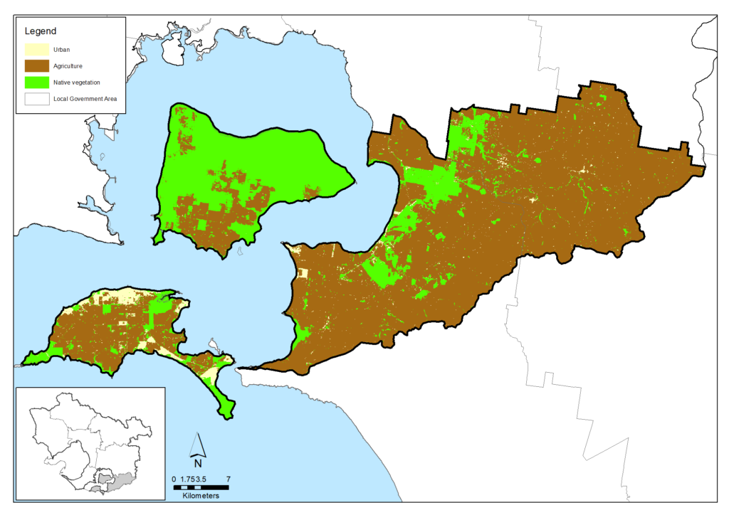
Around 71% of the area is used for agriculture, 26% retains native vegetation and 2% is urban.
Agriculture
Agriculture occupies 60,441 hectares or 71 per cent of the Bass Coast, South Gippsland & islands area with estimated gross value of $96 million in 2015.
Artisan and value-adding businesses are a growing sector alongside the area’s traditional focus on dairy and beef farming. Further detail is available on the Agriculture data section of this website.
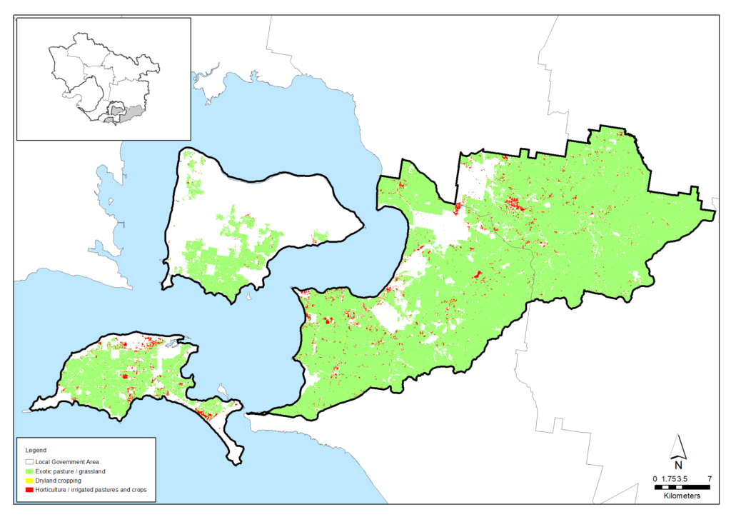
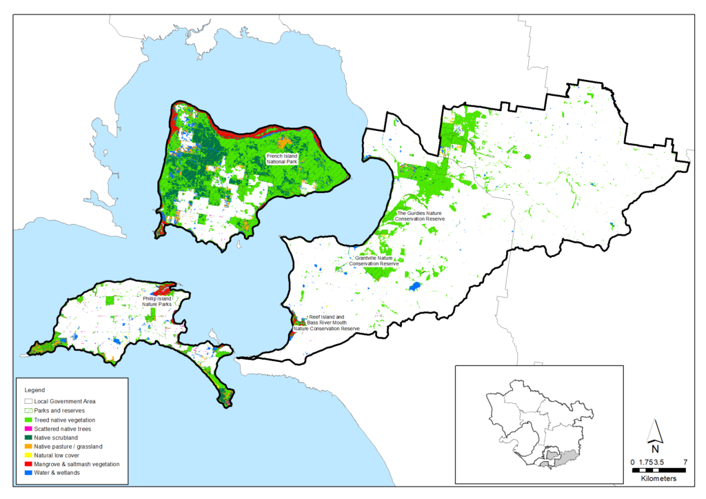
Locations of agriculture types are shown in the map below.
Information on changes to the area of agriculture and other land use types over the last 30 years is outlined on the Land use data section of this website.
| Agriculture data from 2015-16 | Bass Coast, South Gippsland & islands |
|---|---|
| Area of Bass Coast, South Gippsland & islands (Hectares) | 84,919 |
| Area of agriculture (Hectares) | 60,441 (71%) |
| Number of farms | 662 |
| Employment on farms | 1,070 |
| Gross value of annual agricultural production ($) | $96 million |
| Main agricultural commodities | Dairy, beef |
Soil health
Much of the agriculture is located across the area’s cleared Bass Hills. Once covered in tall forest, these hills are visually impressive but parts of their steep slopes can be prone to erosion and land slips and be sources of high sediment and nutrient loads to the area’s waterways and then into Western Port.
There has been, and continues to be, a significant focus by landowners, the Landcare movement and Melbourne Water to revegetate slopes, gullies and waterways of the area to protect the land and waterways and to increase local biodiversity values.
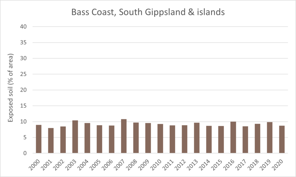
Over the whole area, the proportion of exposed soil has been below 10% for most years since 2000, as shown in the graph below, which indicates that most of the land remains covered and protected by vegetation (including pasture) at all times.
Proportion of exposed soils for the area from 2000 to 2020 (data from Australian National University)
Waterways
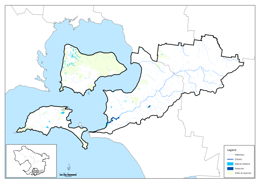
The Bass Coast, South Gippsland & islands area is contained within the Western Port and Mornington Peninsula major catchment and includes the main river and creek systems of the Bass River system as well as several smaller creeks located on French and Phillip Island. The coastal areas are part of the Mornington Peninsula and Western Port Biosphere Reserve which is one of four internationally-recognised biosphere reserves in Victoria.
Rivers and wetland conditions and conservation strategy for the area are described in the Westernport and Mornington Peninsula chapters of the Healthy Waterways Strategy. Waterways generally have a low to high rating across a range of key environmental values and waterway conditions.
The regional Healthy Waterways Strategy assessment of the current physical conditions of rivers in the Westernport catchment and their trajectory (their likely future state under current management practices and investment) is summarised in the table below.
| Waterway values | 2018 state | 2018 trajectory | 2068 target |
|---|---|---|---|
| Birds | Moderate | Moderate | Moderate |
| Fish | Low | High | High |
| Frogs | High | Moderate | High |
| Macroinvertebrates | Moderate | Low | High |
| Platypus | Moderate | Low | Moderate |
| Vegetation | Low | Very low | Moderate |
| Amenity | High | Moderate | Very high |
| Community connection | High | Moderate | High |
| Recreation | High | High | High |
| Waterway conditions | 2018 state | 2018 trajectory | 2068 target |
|---|---|---|---|
| Stormwater | High | Moderate | High |
| Physical form | Moderate | Low | Moderate |
| Water for the environment | High | Moderate | High |
| Vegetation quality | Low | Very low | Moderate |
| Vegetation extent | Low | Low | High |
| Instream connectivity | Moderate | Moderate | High |
| Water quality - environment | Low | Very low | Low |
| Access | Very low | Very low | Low |
| Litter | High | Moderate | Very high |
| Water quality - recreational | High | Moderate | High |
| Participation | Moderate | Low | Very high |
Biodiversity
Native vegetation covers 22,405 hectares or 26 per cent of the Bass Coast, South Gippsland & islands area. Half of this is highly fragmented. Of the 27 major Ecological Vegetation Classes (EVC’s) found in the Bass Coast Shire, 10 are classified as endangered, three vulnerable and three severely depleted. The Phillip Island Nature Park holds important natural values but only 20% of the island has native vegetation cover. 23 rare or threatened native flora species are recorded on Phillip Island.
Only six patches of intact native vegetation larger than 100 hectares remain in the Bass Coast, South Gippsland & islands area. 82 per cent of this is in the 11,000 hectare French Island National Park. French Island’s size, intact habitats and isolation from introduced predators, pollutants and urbanisation makes it one of Victoria’s most valuable conservation reserves.
The diversity of native animal species has declined in this area in response to habitat loss, pest predation and other factors, as indicated in an analysis of animal sighting data that calculated the probability that each species of native fish, amphibians, reptiles, birds and mammals was persisting at the end of 2016.
The analysis indicated that, for the Bass Coast, South Gippsland & islands area, perhaps only 72 per cent of the total number of species recorded here are still persisting. In general, birds seem to have fared the best whereas native fish species seem to been significantly reduced.
| Native species | Number and proportion of species likely to be persisting (at 2016) |
|---|---|
| Birds | 217/274 (79%) |
| Mammals | 19/34 (56%) |
| Amphibians | 6/10 (60%) |
| Reptiles | 11/22 (50%) |
| Fish | 2/15 (13%) |
| Total | 255/355 (72%) |
Threatened species are considered to be priorities for local protection and recovery work. In many circumstances, work to protect and enhance their health and resilience will also benefit other native animal species and the local habitat. The following table shows some of the threatened species and ecological communities that have been recorded in this area. A full list of the threatened species known to occur in this region since 1980 is available at the Data tables section of this strategy.
| Group | Species |
|---|---|
| Birds | Bar-tailed Godwit, Black Falcon, Blue-billed Duck, Caspian Tern, Curlew Sandpiper, Eastern Curlew, Eastern Great Egret, Fairy Tern, Freckled Duck, Giant Gippsland Earthworm, Great Knot, Greater Glider, Hooded Plover, Lesser Sand Plover, Lewin's Rail, Little Egret, Little Tern, Long-nosed Potoroo, Northern Giant Petrel, Orange Bellied Parrot, Plumed Egret, Powerful Owl, Red Knot, Sooty Owl, Southern Brown Bandicoot, Southern Giant Petrel, Swift Parrot, White-bellied Sea-Eagle, White-footed Dunnart, White-throated Needletail |
| Mammals | Southern Brown Bandicoot, Greater Glider, Long-nosed Potoroo, White-footed Dunnart, Platypus |
| Reptiles | Lace Monitor |
| Amphibians | Southern Toadlet |
| Invertebrates | Giant Gippsland Earthworm |
| Flora | Clasping Hypocreopsis, French Island Spider-Orchard, Green-striped Greenhood, Merran’s Sun-orchid, Strzelecki Gum, Swamp Everlasting, Christmas Spider-orchid |
| Ecological communities | Natural Damp Grassland of the Victorian Coastal Plains, Subtropical and Temperate Coastal Saltmarsh, Central Gippsland Plains Grassland, Coastal Moonah Woodland, Forest Red Gum Grassy Woodland, Herb-rich Plains Grassy Wetland (West Gippsland), South Gippsland Plains Grassland |
Coasts
Coasts remain in relatively natural condition across the Bass Coast, South Gippsland and Islands area. Of the 180 kilometres of coast, only Phillip Island’s urbanised north coast retains less than 70 per cent of its native vegetation cover. The world’s most southern mangrove stands are critical vegetation on Western Port’s coasts.
French Island’s northern coast comprises the French Island Marine National Park. The Marine Park’s sea grass beds, mangroves and mud flats are critical habitat for migratory birds under several international conventions. They are a key part of Western Port’s international recognition as a Ramsar wetland.
The area is part of the Mornington Peninsula and Western Port Biosphere Reserve; one of Victoria’s four internationally-recognised biosphere reserves. The reserve’s core area is the least disturbed and protected environments of French Island. Western Port’s waters and wetlands form the Biosphere’s buffer zone. The rural and urban lands surrounding Western Port form the reserve’s transition area. This is where the UNESCO Man and the Biosphere Program’s goals for human activity to co-exist with nature are most pressing.
Phillip Island’s Summerland Peninsula supports an estimated breeding population of 32,000 Little Penguins – around 20 per cent of Victoria’s estimated total breeding population. The ‘Penguin Parade’ is world-famous and Victoria’s major wildlife attraction.
Approximately one million Short-tailed Shearwaters breed in the Phillip Island Nature Parks. These are listed in international agreements to protect migratory birds. The largest shearwater colony is at Cape Woolamai. Others are established on Phillip Island’s south and northwest coasts and on French Island.
Community action
Community volunteering for land, water and nature conservation across the Bass Coast, South Gippsland & islands area is estimated to be worth over $500,000 per year.
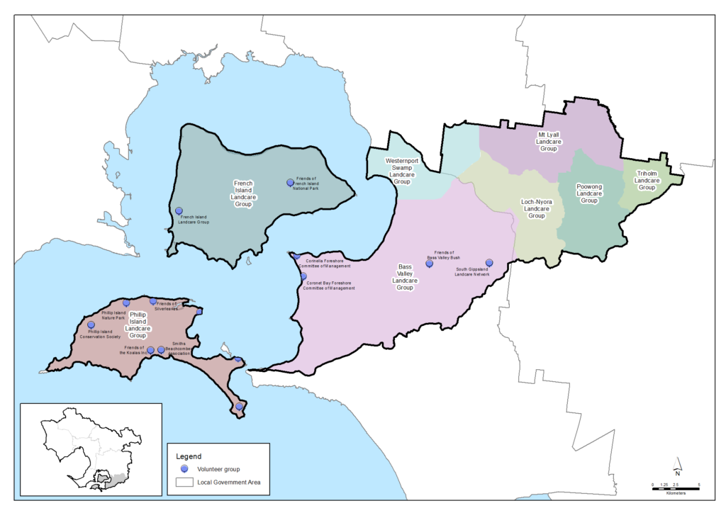
Approximately 471 landholders in 7 Landcare groups are active across the Bass Valley, French Island and Phillip Island and the groups are connected and supported through the Bass Coast Landcare Network.
Local communities are also active in Friends Groups and Committees of Management. The Bass Coast Shire directory lists 15 coastal conservation groups in the Phillip Island/San Remo area.
Phillip Island Nature Parks (PINP) is a unique and successful self-funded organisation. It manages 1,805 hectares of Crown Land on Phillip Island. 300 volunteers contributed 13,310 hours to PINP’s conservation and visitor experience work in 2019-20.
More detail is available in the Community volunteering data section of this website.
Current and future challenges for natural resource management
Advancing the Bunurong people’s connection with Country
There is a challenge to strengthen the role and influence of traditional ecological knowledge and practices in today’s natural resource management programs, where that is allowed and offered by Traditional Owners.
There are currently relatively few Aboriginal people who have jobs taking care of Country in this region. There is a challenge in providing timely, tailored support for Registered Aboriginal Parties and other Aboriginal organisations so they can determine their aspirations and build their workforce to suit their aims with the appropriate range of skills.
Traditional Owners’ rights to water have largely been excluded from water planning and management policies and programs. Without water rights, Traditional Owners are unable to decide where or how water can be used to support cultural, spiritual, environmental or economic outcomes. There is an opportunity to address this in water planning and by securing bulk water allocations for Registered Aboriginal Parties to enable cultural watering.
Biodiversity risk
The paucity of native vegetation cover across the Bass Coast, South Gippsland & islands area is a risk to the sustainability of native species. The 2004 biodiversity study How much habitat is enough? showed that landscapes with less than 15% vegetation cover may support diverse but low populations of native plant and animal species, but their future is not assured.
The study recommends that increasing vegetation cover above 15% could be an intermediate revegetation goal while 35% cover should be a goal where practicable. This is partly consistent with the Bass Coast Shire Natural Environment Strategy 2016-26 goal to increase native vegetation cover and biolinks to over 15% of the Shire by 2026.
Climate change
The regional climate change report, Climate Change in the Port Phillip & Western Port Region, identifies risks and responses to warmer, drier conditions and rising sea levels across the region. The report says climate change will particularly affect the following environmental assets in the Bass Coast, South Gippsland & islands area:
- Native vegetation remnants north and south of Loch, The Gurdies, Grantville and Glen Forbes.
- The upper reaches of the Bass and Lang Lang Rivers.
- Coastal native vegetation on Phillip Island at Cape Woolamai, The Nobbies, Summerlands, Churchill Island and French Island.
- Coastal wetlands on French Island and Rhyll.
- Coastal soils on Phillip Island from Smith Beach to Woolamai, around Cowes and south of Ventnor
Climate Risk Assessments developed by Local Government-based Alliances for Greenhouse Action around Melbourne and work by the South East Councils Climate Change Alliance indicate:
- Vulnerability to climate change is compounded for newly arrived migrants, the aged and young children and people living in relative poverty, in sub-standard housing or with poor English
- Lack of understanding of local flora and fauna species responses to climate change is hampering timely and effective investment and action for biodiversity conservation
- Social and policy pressures for larger fire breaks and more fuel-reduction burning is impacting biodiversity and air quality
- Changing wildfire frequency and intensity in warmer, drier conditions is damaging biodiversity and increasing demands for fire-management effort
- Fire agency management planning often conflicts with the environmental protection goals and targets of local, regional and state environment strategies.
Urbanisation and population pressures
Population forecasts for Bass Coast Shire predict population growth from 36,000 in 2021 to 46,400 by 2036. This growth is predicted to see nearly 1,000 new dwellings on the Western Port coast, 2,000 on Phillip Island and 500 in the Shire’s rural areas.
Urban development brings:
- Demands for space, facilities, transport infrastructure and access to recreation areas
- Damage from illegal clearing, vehicle tracks, vandalism, feral animals, firewood collection and rubbish dumping
- Altered stream flows and water pollution from increased hard-surface run-off
- Waterways habitats damaged by flood protection works and sediment inputs
- Reduction in agricultural area and local food production
- Barriers to animal movement created by roads and infrastructure
- Continuing habitat damage from recreation, vandalism, informal vehicle tracks and rubbish
- Continued clearing for buildings, fences, access, views etc.
- Feral domestic animals
- Pest plants and plant diseases such as Phytophthora cinnamoni spread by humans, birds and animals and from dumped garden waste.
French Island’s natural values are currently protected from these population and development futures by its relative isolation, governance arrangements that inhibit development and the difficulty of taking motor vehicles onto the island.
The coasts and beaches also hold some of Victoria’s most valuable shorebirds and seabird habitats. Careless boating, fishing and walking and associated intrusions by dogs and horses can cause significant disturbance and adverse impacts on coastal bird species, their breeding and migration success. Education and enforcement to protect vulnerable species during their breeding seasons are important conservation actions.
Weeds and pest animals
Pest plants and environmental weeds are a major threat to the area’s natural environment. Once established, they grow vigorously because they have few natural predators or diseases to control them. They change and destroy habitats and ecosystems, outcompeting indigenous plants for light, nutrients and water. This leaves our wildlife without food and habitat, leading to the decline of our native animals. Many pest plants are spread from domestic gardens. Seeds are spread by birds and animals or by people dumping garden cuttings into our bush and waterways. Coastal weeds such as Sea spurge invade the nesting habitats of shorebirds and seabirds.
Pest animals significantly impact on native plants and animals and their habitats. Foxes and cats, in particular, are exceptional hunters and are the primary cause of the decline and extinction of many smaller native animals. Other pest animals including rabbits directly compete with native wildlife for food and shelter, damage native vegetation and degrade the land, while introduced fish species compete for food and prey on native fish, tadpoles and frogs.
Policy and planning
Land, water and biodiversity in the Bass Coast, South Gippsland & islands area are principally managed by its two municipal councils, Melbourne Water, Parks Victoria, the Department of Department of Energy, Environment and Climate Action and EPA Victoria with support from landholders and other authorities, organisations and community groups. The area’s most significant strategies and plans include:
- Bass Coast Shire Council Natural Environment Strategy 2016-26 – Strategy to mitigate climate change impacts, facilitate sustainable public access to natural environments, protect biodiversity and native vegetation and promote environmental awareness.
- Bass Coast Shire Council Biodiversity Biolinks Plan 2018 – This is a plan to link remnant patches of native vegetation across landscapes by creating biolinks. The aim is to restore wildlife movement and genetic diversity in populations of plants and animals.
- Climate Change Action Plan for Bass Coast 2020-2030 – identifying a number of actions that individuals, community groups, businesses, the agricultural sector and Council can undertake to achieve the objective of zero net emissions over the next 10 years and to ensure a climate resilient community.
- Phillip Island Nature Parks Management Plans – A set of 13 plans that identify optimal management for the natural assets in the care of Phillip Island Nature Parks.
- The regional Healthy Waterways Strategy provides vision statements, goals, 10 and 50-year targets and 10-year performance objectives for waterway management in each of the region’s five major catchments (Werribee, Maribyrnong, Yarra, Dandenong and Westernport). The Bass Coast, South Gippsland and Islands area is drained by streams in the Western Port catchment.
- Protecting Victoria’s Environment – Biodiversity 2037 – The Victorian Government’s statewide strategy to arrest biodiversity decline. It describes goals for community awareness through connection with nature and for physical habitat protection and improvement.
An Asset Vulnerability Assessment and a Community Climate Change Action Plan are being developed by the South East Councils Climate Change Alliance.
Traditional Owners are the voice of their Country
For all policy and planning, there is a need for recognition and inclusion of Traditional Owner knowledge and aspirations. The waterways and lands are increasingly being recognised as ‘living and integrated natural entities‘ and the Traditional Owners should be recognised as the ‘voice of these living entities’. A Country Plan being prepared by the Bunurong Land Council Aboriginal Corporation will describe the vision and priorities of the Traditional Owners for Country in line with their role as a Registered Aboriginal Party, and provide a strong basis for all planning to recognise and include the voice of these Traditional Owners.
Vision and targets for the future
Vision
The Traditional Owners of this area, the Bunurong people, have cared for this Country for tens of thousands of years. A vision for its future will be outlined in the Bunurong Country Plan (in preparation).
The Bass Coast Shirt Council Plan 2017-21 vision statement is:
Bass Coast will be known as a region that supports a sustainable and healthy community, and values and protects its natural assets.
and its Natural Environment Strategy 2016-26 sets four strategic directions:
- Mitigate the forecast impacts of climate change by integrating the predictions into our decision making and planning for infrastructure, services and utilities
- Facilitate appreciation of our unique natural environment through sustainable public access
- Improve health of the landscape through increased biodiversity and indigenous vegetation protection
- Develop community partnerships that promote environmental awareness.
The South Gippsland Shire Council Sustainability Strategy 2016-2020 includes the following vision:
To be a municipality that values its local people, flora and fauna and is committed to actively and collaboratively engaging with its community and other partners in protecting the environment and benefiting from sustainable opportunities.
and sets the following six directions:
- Ensure the conservation and enhancement of the diversity of South Gippsland’s indigenous flora and fauna
- Manage South Gippsland’s coastal and bushland reserves to protect and enhance their natural and recreational values
- Identify risks associated with climate change. Manage these risks by implementing adaptation measures
- Ensure efficient and minimal energy and resources used in all South Gippsland Shire Council operations and within the broader community.
- Encourage development within South Gippsland that is sustainable, minimises impacts on the natural systems and is consistent with the needs of the community
- Improve local knowledge of sustainability principles and practices through active engagement and education of community.
Regional Catchment Strategy targets
The following long-term targets for the Bass Coast, South Gippsland & islands area (at the year 2050 or further) reflect the region-scale vision of the Regional Catchment Strategy and the visions and directions of the local councils, the Healthy Waterways Strategy, other plans and the community. They will contribute to achieving these visons and objectives and help ensure this area remains healthy and prosperous for future generations. The targets are the local contributions towards achieving regional-scale targets outlined in the ‘Themes‘ section of this strategy.
Partner organisations for the journey ahead
The following organisations formally support the pursuit of the Regional Catchment Strategy’s targets for the Bass Coast, South Gippsland & islands area. They have agreed to provide leadership and support to help achieve optimum results with their available resources, in ways such as:
- Fostering partnerships and sharing knowledge, experiences and information with other organisations and the community
- Seeking and securing resources for the area and undertaking work that will contribute to achieving the visions and targets
- Assisting with monitoring and reporting on the condition of the area.
Traditional Owners
- Bunurong Land Council Aboriginal Corporation
Local Government
- South Gippsland Shire Council
- South East Councils Climate Change Alliance
- Bass Coast Shire Council
Community
- Bass Coast Landcare Network
- Bass Valley Landcare Group
- French Island Landcare Group
- South Gippsland Landcare Network
- Loch-Nyora Landcare Group
- Mt. Lyall Landcare Group
- Poowong & District Landcare Group
- Triholm Landcare Group
- Phillip Island Landcare Group
- Gippsland Threatened Species Action Group
Victorian Government
- Melbourne Water
- Parks Victoria
- South Gippsland Water
- Westernport Water
- Sustainability Victoria
- Zoos Victoria
- Environment Protection Authority Victoria (EPA)
- Victorian Planning Authority
- Victorian Fisheries Authority
- Trust for Nature
- Phillip Island Nature Parks
- Victorian Environmental Water Holder
Non Government
- Western Port Biosphere Reserve Foundation
- Dolphin Research Institute
- The Nature Conservancy
- Birdlife Australia
- Gardens for Wildlife Victoria
- Western Port Seagrass Partnership
- Habitat Restoration Fund
- Victorian National Parks Association
- GippsDairy
- Conservation Volunteers Australia
- Native Fish Australia (Vic)
- OzFish Unlimited
- The People and Parks Foundation
- Field Naturalists Club of Victoria
Add your organisation as a supporter and partner
If your organisation supports these directions and targets for Bass Coast, South Gippsland & islands, it can be listed as a partner organisation. Adding your organisation to this list will:
- enable your organisation to list one or more priority projects in the Prospectus which will describe how your priority project will pursue the targets of this Regional Catchment Strategy and potentially make your organisation’s project more attractive to investors by using the strategy to highlight its relevance and value
- demonstrate your commitment to a healthy and sustainable environment
- demonstrate the level of community engagement and support for this work.
Priority projects to move forward
Priority projects
There are significant ongoing programs and initiatives undertaken by many organisations that are vital for the management of natural resources and the support of communities in the Bass Coast, South Gippsland & islands area. In addition, there are numerous project proposals that, if funded and implemented, can contribute to achieving the Regional Catchment Strategy’s visions and targets for the area. They include projects that:
- Establish new vegetation in large-scale, strategic locations where it provides multiple benefits by contributing to carbon sequestration, habitat restoration and habitat connectivity
- Help achieve net gain in the extent and condition of habitat across public and private land, coasts and waterways
- Protect waterways
- Protect threatened species
- Support soil health and the adoption of sustainable agriculture practices
- Support resilience to climate change in agricultural enterprises and communities
- Increase community participation, engagement, education and enjoyment in nature and conservation
- Strengthen Traditional Owners roles in environmental decision-making and action.
Project proposals include:
- Environmental education and community action in the Bass Coast proposed by the Bass Coast Landcare Network
- Climate adaptation planning for Bass Coast landowners proposed by the Bass Coast Landcare Network
- Bass Coast Biodiversity Biolinks led by the Bass Coast Shire Council
- Community-led pest control around Western Port proposed by the Bass Coast Landcare Network
- Measuring what matters proposed by the Bass Coast Landcare Network
- Fert$mart led by GippsDairy
- Building Site Action Plans for Migratory Seabirds led by Birdlife Australia
- Reef Island and Bass River Mouth Nature Conservation Reserve Introduced Predator Management proposed by Parks Victoria
- Reef Island and Bass River Mouth Nature Conservation Reserve Terrestrial Herbivore Management proposed by Parks Victoria
- Western Port Intertidal Coastal Reserve Terrestrial Herbivore Management proposed by Parks Victoria
- French Island Introduced Predator Management proposed by Parks Victoria
- French Island National Park Terrestrial Herbivore Management proposed by Parks Victoria
- French Island National Park Weed Control proposed by Parks Victoria.
A list of project proposals and their key details can be viewed and sorted on the Prospectus section of this website.
Propose a new priority project
As part of the ongoing development and refinement of this Regional Catchment Strategy, additional priority projects may be considered for inclusion in the Prospectus.
If your organisation supports the directions and targets for this area, and has a project it would like highlighted and supported in this Regional Catchment Strategy, please submit a Prospectus Project Proposal.

